


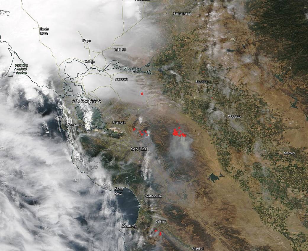
NOAA/NASA’s Suomi NPP satellite shows the aftermath of a series of lightning strikes that set 29 fires ablaze in Northern California in this image taken on Aug. 18, 2020. The majority of these fires started on or around August 17, 2020. The fires range in size from 14 acres, the Beach Fire, all the way up to the largest of these fires, the Canyon Zone fire which is a complex of six fires, that is a total of 10,000 acres and 0% contained. The Loyalton fire, currently the largest fire in California, located near the Tahoe National Forest and near the border with Nevada is 43,444 acres in size and 10% contained. This fire’s cause, though, is still under investigation and not yet attributed to a lightning strike. Lightning remains a major cause of wildfires and the storms that have passed through Northern California are wreaking havoc for firefighters. There seems to be no relief in sight for this region, however, as the National Weather Service is predicting, “Persistent and dangerous heat continues across much of the West. Dozens of records will be possible. This heat combined with dry conditions and isolated to scattered dry thunderstorms may produce new fire starts. Gusty winds, some severe, with thunderstorms will produce rapid fire spread for any new fires and existing fires.”
NASA’s satellite instruments are often the first to detect wildfires burning in remote regions, and the locations of new fires are sent directly to land managers worldwide within hours of the satellite overpass. Together, NASA instruments detect actively burning fires, track the transport of smoke from fires, provide information for fire management, and map the extent of changes to ecosystems, based on the extent and severity of burn scars. NASA has a fleet of Earth-observing instruments, many of which contribute to our understanding of fire in the Earth system. Satellites in orbit around the poles provide observations of the entire planet several times per day, whereas satellites in a geostationary orbit provide coarse-resolution imagery of fires, smoke and clouds every five to 15 minutes. For more information visit: https://www.nasa.gov/mission_pages/fires/main/missions/index.html
NASA’s Earth Observing System Data and Information System (EOSDIS) Worldview application provides the capability to interactively browse over 700 global, full-resolution satellite imagery layers and then download the underlying data. Many of the available imagery layers are updated within three hours of observation, essentially showing the entire Earth as it looks “right now.” Actively burning fires, detected by thermal bands, are shown as red points. Image Courtesy: NASA Worldview, Earth Observing System Data and Information System (EOSDIS). Caption: Lynn Jenner with information from Inciweb and CAL Fire.