


![Request for Information – Potential [Placeholder for Prize]](https://assets.science.nasa.gov/dynamicimage/assets/science/missions/a-step/FFR_Earth_Background_20251120%20.png?w=1024)


 NASA’s Beechcraft B200 Super King Air N801NA carries the Autonomous Modular Sensor, a high-tech thermal-infrared scanning instrument that can see through smoke and haze to aid fire fighters in battling wildfires. (NASA / Lori Losey) › View Larger Image EDWARDS, Calif. – As the summer blazes on, NASA-developed infrared imaging technology will once again be used to support wildfire incident commanders in California.
Beginning in September and continuing through the end of October, a NASA thermal-infrared scanning instrument, mounted in a NASA Beechcraft B200 King Air, will stand ready to support the U.S. Forest Service and the California Department of Forestry and Fire Protection (CAL FIRE) with real-time imagery of fire characteristics.
NASA has a history of assisting with imaging wildfires and this summer will be no different. NASA has developed a thermal-infrared wildfire scanner that detects hot spots and various elements of the fire and burn characteristics, including post-fire burn severity.
“The use of the Autonomous Modular Sensor (AMS) sensor to support wildfire incident management personnel, will provide benefits to the people of California by enabling CAL FIRE to derive near-real-time information on major wildfire events, helping to save time, resources, property and potentially lives,” said Vince Ambrosia of NASA’s Ames Research Center, Moffett Field, Calif., the project’s principal Investigator.
“The second benefit is in the long-term partnership between the entities, which allows some of these NASA-derived technologies to be matured to operational utility and adopted for use by the disaster support agencies in the state…a win-win for the residents and tax payers of California,” he added.
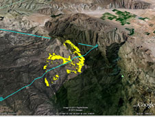 The false-color yellow markings on this image taken July 22, 2011 by NASA’s Autonomous Modular Sensor represent hot spots of the Eagle fire in San Diego County, Calif. The blue lines represent the approximate flight path of NASA’s King Air aircraft that carried the scanner. (NASA/Google image) › View Larger Image While in the air, the scanner collects imagery that is translated into real-time, on-board, autonomous data delivered through a satellite communications system to servers at NASA Ames. From there, the data are made available in many Web service formats, including formats viewable within the Google Earth visualization tool.
“It’s that combination of sensors, aircraft, network and communications that advances the wildfire fighting state-of-the-art,” added Randy Albertson of NASA’s Airborne Science Program.
The aircraft with the AMS installed flies over the fire and collects spectral and thermal information about the fire and the surrounding landscape characteristics. This data is used by incident managers on the ground to plan mitigation strategies and fight the fire.
“The information provided by the sensor is helpful in containing the fire and preventing it from spreading,” said remote sensing satellite specialist Tom Zajkowski of the U.S. Forest Service.
NASA Ames and CAL FIRE have previously collaborated on wildfire support exercises. In 2010, they entered into a five-year non-reimbursable Space Act Agreement to use NASA technology and capabilities to help support the management and mitigation of wildfire disasters and to seek paths to transfer the technology to agencies such as CAL FIRE, following many years of cooperation between the agencies.
“The B200 King Air recently completed checkout flights of the onboard equipment, including the AMS instrument over active fires in addition to post-burn assessment,” said Marty Trout, NASA B200 project pilot at the Dryden Flight Research Center at Edwards, Calif. “The aircraft and ground control teams are ready to fly missions during the fall fire season.”
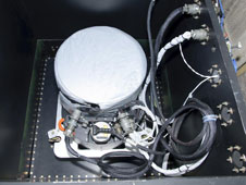 Mounted in a box on the floor of NASA’s B200 King Air, the Autonomous Modular Scanner peers out through an aperture in the bottom of the aircraft. The scanner operates like a digital camera with special filters to detect light energy at visible, infrared and thermal wavelengths as it peers through smoke and haze to detect active hot spots in wildfires. (NASA / Tony Landis) › View Larger Image In 2006, with the AMS mounted in the General Atomics Aeronautical Systems’ Altair unmanned aircraft, NASA provided real-time fire information to the incident management team on the Esperanza Fire near Banning, Calif. From 2007 to 2009, the AMS flew on NASA’s Ikhana unmanned aerial vehicle gathering information about wildfires for incident team leaders and to support research on fire behavior and post-fire recovery. Although the Ikhana missions were valuable, the investigators didn’t have the ease of use that a manned aircraft offered. In order to realize easier access to the National Airspace System, scientists turned to the manned B200 aircraft this year for routine mission operations.
“The September – October period is one of California’s most problematic seasons for wildfire activity, especially in Southern California, where Santa Ana-driven wildfires routinely lick at the margins of major metropolitan areas like Los Angeles and San Diego.” Ambrosia said.
“By planning for operations during that time of year, and staging the NASA B200 and the AMS sensor at NASA’s Dryden Flight Research Center at Edwards Air Force Base, we hope to rapidly deploy the system to support those fast moving Southern California events,” Ambrosia said. “That will provide the Incident teams with quicker and more frequent fire information, in order to assess and combat and control the wildfires before they spread catastrophically into those urban wildland fringe areas.”
For more information about the Ikhana wildfire missions, visit:
https://www.nasa.gov/centers/dryden/news/Features/2007/wildfire_socal_10_07.html
For more information about the collaboration with CAL FIRE, visit:
https://www.nasa.gov/centers/ames/news/releases/2010/10-119AR.html
– end –
text-only version of this release
To receive status reports and news releases issued from the Dryden Newsroom electronically, send a blank e-mail message to dfrc-subscribe@newsletters.nasa.gov. To unsubscribe, send a blank e-mail message to dfrc-unsubscribe@newsletters.nasa.gov. The system will confirm your request via e-mail.
Beth Hagenauer
Dryden Flight Research Center, Edwards, Calif.
661-276-7960
beth.hagenauer-1@nasa.gov
Karen Jenvey
Ames Research Center, Moffett Field, Calif.
650-604-40034
karen.jenvey@nasa.gov