


![Request for Information – Potential [Placeholder for Prize]](https://assets.science.nasa.gov/dynamicimage/assets/science/psd/solar/2023/09/s/solarsystem_0.jpg?w=1024)


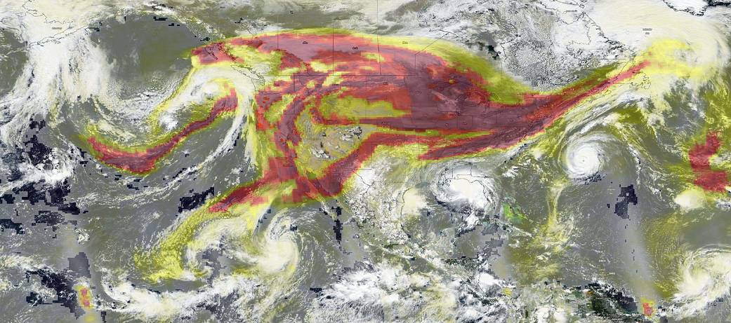
Aerosols are the focus of this image captured on Sep. 14, 2020 by NOAA/NASA’s Suomi NPP satellite, but hurricanes also make an appearance around the edges. The OMPS (Ozone Mapping Profiler Suite) instrument aboard NOAA/NASA’s Suomi NPP satellite detected and measured the atmospheric aerosol layer in terms of thickness and height. For most atmospheric events involving aerosols, the AI ranges from 0.0 (colorless through light yellow, yellow, orange, and red) to 5.0 (deep red), with 5.0 indicating heavy concentrations of aerosols that could reduce visibilities or impact health. In this image, much of the United States is covered with a deep red color but it should be noted that the OMPS measures high aerosols being carried in the upper atmosphere. The worst of the air quality is still found on the west coast, but aerosols have many other effects on our planet.
Aerosols can affect cloud and precipitation to suppress light rainfall but intensify heavy rainfall and lightning. High aerosols can also produce very dense, very reflective, and bright white clouds that can block sunlight from reaching Earth’s surface, shading the planet and producing net cooling. Aerosols, particularly black carbon, can also alter reflectivity by depositing a layer of dark residue on ice and other bright surfaces. In the Arctic especially, aerosols from wildfires and industrial pollution are likely hastening the melting of ice. In a story published on NASA.gov by Langley Research Center, the way aerosols are removed was discussed: “It is believed that much of the removal of atmospheric aerosols occurs in the vicinity of large weather systems and high altitude jet streams, where the stratosphere and the lower atmosphere become intertwined and exchange air with each other. In such regions, many pollutant gases in the troposphere can be injected in the stratosphere, affecting the chemistry of the stratosphere. Likewise, in such regions, the ozone in the stratosphere is brought down to the lower atmosphere where it reacts with the pollutant rich air, possibly forming new types of pollution aerosols.”
One other feature to note in this image is the preponderance of hurricanes/tropical storms that are visible in this image. Off the west coast of Mexico is Tropical Storm Karina. Making landfall near Louisiana and Alabama is Hurricane Sally. Out in the Atlantic Ocean near Bermuda is Hurricane Paulette, and in the lower right hand corner of the image near the Lesser Antilles is Tropical Storm Teddy. In the Gulf of Mexico, Hurricane Sally is poised to make landfall in the Northern Gulf states, while in the Atlantic Ocean, Hurricane Paulette is moving away from Bermuda.
NASA’s Earth Observing System Data and Information System (EOSDIS) Worldview application provides the capability to interactively browse over 700 global, full-resolution satellite imagery layers and then download the underlying data. Many of the available imagery layers are updated within three hours of observation, essentially showing the entire Earth as it looks “right now.” Actively burning fires, detected by thermal bands, are shown as red points. Image Courtesy: NASA Worldview, Earth Observing System Data and Information System (EOSDIS). Caption: Lynn Jenner with information from Earth Observatory.