


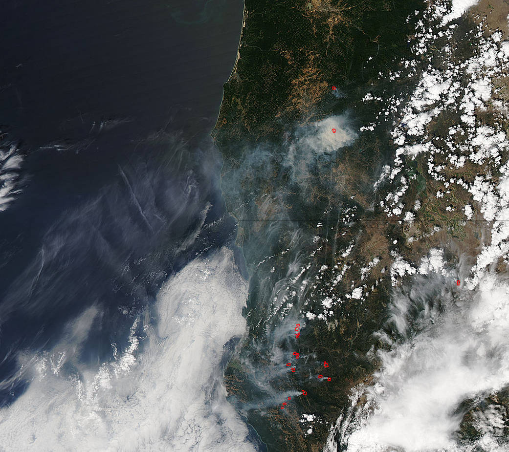
This satellite image shows smoke from several fires in Oregon and California on Aug. 2, 2015. The Moderate Resolution Imaging Spectroradiometer (MODIS) instrument that flies aboard NASA’s Aqua satellite captured an image of smoke from these fires Aug. 2 at 21:05 UTC (5:05 p.m. EDT). The multiple red pixels are heat signatures detected by MODIS. The smoke appears to be a light brown color.
InciWeb is an interagency all-risk incident information management system that coordinates with federal, state and local agencies to manage wildfires.
In Oregon smoke from the Cable Crossing Fire, the Stouts Fire and the Potter Mountain Complex Fire commingle. The Cable Crossing Fire was reported burning on forestlands protected by the Douglas Forest Protective Association (DFPA) at approximately 3:25 p.m. on Tuesday, July 28, 2015, near Oregon Highway 138 East, near Mile Post 23, east of Glide.
South of the Cable Crossing Fire is the Stouts Fire also in forestlands of the DFPA. This fire was reported on Thursday, July 30, 2015, burning approximately 11 miles east of Canyonville near the community of Milo.
East of the other fires is the Potter Mountain Complex Fire. These fires are located in the Deschutes Forest consists of eight fires. According to Inciweb they were started by dry lightning on Saturday, Aug. 2, at approximately 5:30 p.m. about five miles north of Toketee Lake.
In northern California, smoke from the River Complex Fire, the Fork Complex Fire and the Shf July Lightning Fire was visible in the MODIS image.
The River Complex currently consists of seven reported and observed fires on the Six Rivers and Shasta Trinity National Forests. Originally identified as 18 fires, some have burned together. Inciweb noted that in the Six Rivers National Forest there are fires in the Trinity Alps Wilderness. Those fires include the Groves Fire and the Elk Fire. In the Shasta-Trinity National Forest the fires include the Happy Fire at 2,256 acres, Daily Fire at 16 acres, the Look Fire at 7 acres, Onion Fire at 136 acres and Smokey Fire at 1 acre.
In the same forest, south of the River Complex is the Fork Complex fire. Inciweb reported that the Fork Complex consists of (at current count) over 40 fires, all of which were ignited by lightning between July 29 and 31, 2015. To the southwest of this complex is the Mad River Complex. This is a series of seven lightning fires that started on July 30, 2015 after a lightning storm moved through Northern California.
To the east of this and the other fires, burns another near Redding, California, called the Shf July Lightning Fire. This is also under the Shasta-Trinity National Forest management. At 8 p.m. PDT on Aug. 2, Inciweb reported that approximately 15 lightning strikes occurred within 24 hours throughout the Shasta Trinity National Forest and resulted in two new fires. The Caves fire, east of Mt. Shasta, is approximately one-tenth of an acre. The Bluejay fire, east of Shasta Lake, is approximately four acres.
Image credit: NASA Goddard’s MODIS Rapid Response Team, Jeff Schmaltz
Text credit: Rob Gutro, NASA’s Goddard Space Flight Center, Greenbelt, Md.