


A global standard limiting sulfur in ship fuel reduced artificial “ship track” clouds to record-low levels in 2020. Pandemic-related disruptions played a secondary role.
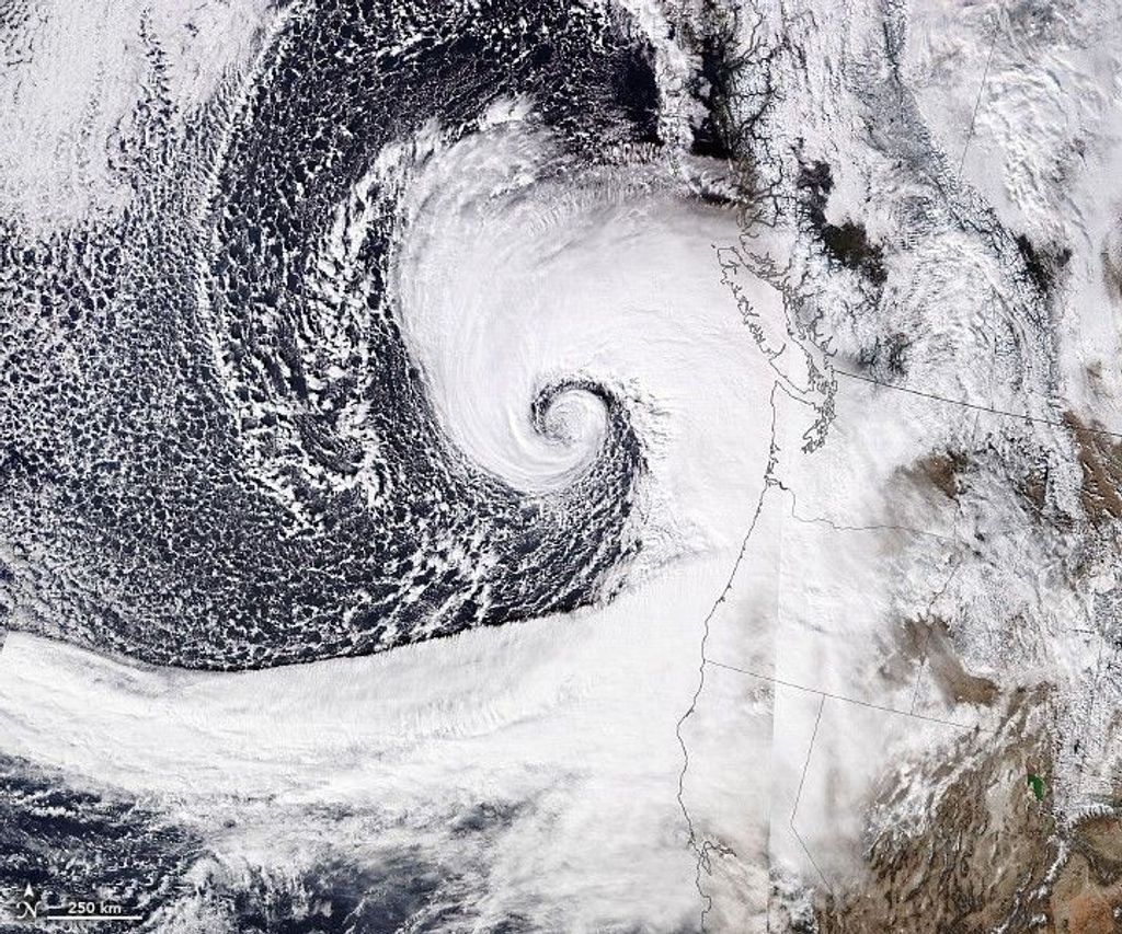
Ship tracks, the polluted marine clouds that trail ocean-crossing vessels, are a signature of modern trade. Like ghostly fingerprints, they trace shipping lanes around the globe, from the North Pacific to the Mediterranean Sea. But in 2020, satellite observations showed fewer of those pollution fingerprints.
Drawing on nearly two decades of satellite imagery, researchers found that the number of ship tracks fell significantly after a new fuel regulation went into effect. A global standard implemented in 2020 by the International Maritime Organization (IMO) – requiring an 86% reduction in fuel sulfur content – likely reduced ship track formation. COVID-19-related trade disruptions also played a small role in the reduction.
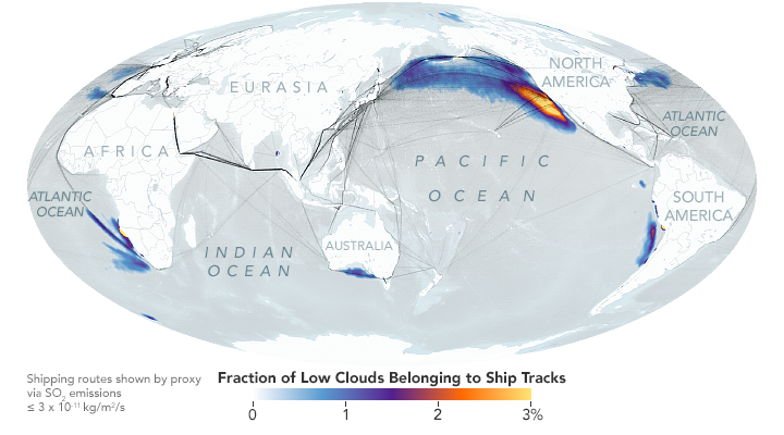
Scientists used advanced computing techniques to create the first global climatology (a history of measurements) of ship tracks. They used artificial intelligence to automatically identify ship tracks across 17 years of daytime images (2003-2020) captured by NASA’s Moderate Resolution Imaging Spectroradiometer (MODIS) aboard the Aqua satellite.
“Without this kind of complete and large-scale sampling of ship tracks, we cannot begin to completely understand this problem,” said lead author Tianle Yuan, an atmospheric scientist at NASA’s Goddard Space Flight Center in Greenbelt, Maryland, and the University of Maryland, Baltimore County.
Ship tracks were first observed as “anomalous cloud lines” in early weather satellite images acquired in the 1960s. They are formed by water vapor coalescing around small particles of pollution (aerosols) in ship exhaust. The highly concentrated droplets scatter more light and therefore appear brighter than non-polluted marine clouds, which are seeded by larger particles such as sea salt.
By capping fuel sulfur content at 0.5% (down from 3.5%), IMO’s global regulation in 2020 changed the chemical and physical composition of ship exhaust. Less sulfur emissions mean there are fewer of the aerosol particles released to form detectable ship tracks.
According to the Yuan and colleagues, similar but regionally defined sulfur regulations – such as an IMO Emission Control Area in effect since 2015 off the west coast of the U.S. and Canada – had not had the desired effect because operators altered their routes and charted longer courses to avoid designated zones.
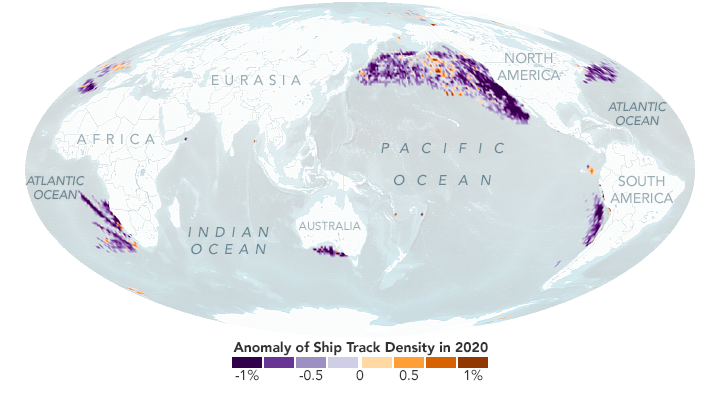
While analyzing 2020 data, the researchers found that ship-track density fell that year in every major shipping lane. (See the map above.) Ship-based tracking data indicated that the COVID-19 pandemic played a role by decreasing global shipping traffic by 1.4% for a few months. But this change alone could not explain the large decrease in observed ship tracks, which remained at record-low levels through several months of 2021 (the most recent data analyzed). The researchers concluded that the new global fuel regulation played the dominant role in reducing ship tracks in 2020.
Over the long span of their analysis, Yuan and colleagues also found that fluctuations in economic activity leave distinct traces in the satellite record. In particular, Trans-Pacific ship track patterns between Asia and the Americas reflect dips and spikes in trade. As outlined in the study, a general upward trend in shipping activity between 2003 and 2013 — reflected in ship-track clouds — dropped for about a year in the aftermath of the 2008 global financial crisis. An even sharper decrease between 2014 and 2016 likely reflected a slowdown in Chinese imports and exports of raw materials and commodities.
Beyond their world trade significance, ship tracks can serve as case studies for an element of climate change. “Ship tracks are great natural laboratories for studying the interaction between aerosols and low clouds, and how that impacts the amount of radiation Earth receives and reflects back to space,” Yuan said. “That is a key uncertainty we face in terms of what drives climate right now.”