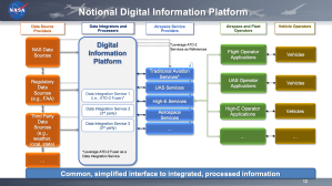


Services Overview
NASA-developed services are available to optimize airspace operations using real-time data and advanced analytics. These services provide flight, airspace, and weather insights, helping users make informed decisions. Prediction capabilities, powered by machine learning, promote better planning and resource management. Services also can be used as building blocks for higher level services using the extensive historical, current, and predicted analytics. While NASA services are currently featured, services from other providers are in the approval process.
Streaming Services
The subproject’s streaming services provide near-real-time access to the fast-paced world of aviation data. While DIP can handle large volumes of streaming data, custom filtering can be utilized to limit the data to specific airlines and/or airspace facilities, such as airports, centers, etc.
Fuser
The Fuser service aggregates flight data from multiple Federal Aviation Administration (FAA) sources, airline data, and 3rd party data into a unified source. The Fuser mediates between disparate data sources to pull the right data at the right time. It parses and fuses data together using a well-defined schema and provides globally unique flight Identifiers to handle flight information. Fuser products are available in the Flight Information Exchange Model (FIXM) format, as well as a flat, non-hierarchical text format and are offered for both public and collaborative decision-making users.
Query-based Services
Query-based services allow clients to request specific resources and representations, providing flexibility in retrieving only the data they need. Using the industry-standard Representational State Transfer (REST) architectural style, users benefit from a streamlined experience that ensures quicker access to relevant information without unnecessary data overload.
Machine Learning (ML) REST Services
These services use ML models trained at several major airports using aviation data to make various predictions involving airport configuration, runway assignments, flight times, and taxiways. They can be utilized in a what-if capacity to determine the predictions based on given input parameters. The Application Programming Interface (API) pages provide the ability to try out the service and inspect its data schemas.
Data Access REST Services
Data access services provide near real-time data from Fuser, using queries. The services return a collection of predictions and resources filtered by flight, time period, and airport. These services provide data from the current time up to 30 days old. Data access REST Services include arrival/departure runway use, on/off times, taxi in/out times, timeline services, and various Traffic Management Initiatives (TMIs) to name a few.
Archival Services
Archival services provide access to historical data captured in file-based format. Fuser files in parquet format are available via secure file transfer protocol. Other data available includes flight summaries, and public traffic management initiatives.
Web Applications – ATC/Airline-Specific Decision-Making Tools
Decision support web applications are offered for air traffic controllers and airline users. Unlike the data-only services, these interactive, graphical applications are web-based and provide information to enhance decision-making in real time. These applications, built using other available DIP services, provide end users decision support tools such as NASA’s pre departure rerouting tool.
Pre Departure Rerouting
NASA’s pre departure rerouting tool helps airlines reduce departure delays by identifying and evaluating alternate routes. When departure demand exceeds capacity at the boundary of terminal airspace, due to high traffic or weather, the tool provides reroute options that reduce ground delays as well as aircraft fuel consumption. Airlines can submit reroute requests digitally through the web-based user interface, enabling efficient coordination with air traffic control to quickly implement the new route.

Airspace Status Map
The airspace status map application provides customizable maps of terminal airspaces within the US, including airports and meter fixes located at the boundaries of terminal airspace. Using traffic management initiative data, the map displays restrictions at arrival and departure fixes in real time – including fix closures and miles-in-trail restrictions.

Timeline
The timeline application displays flight data graphically in chronological order, including scheduled and earliest times for arrivals and departures for runways or fixes at specific airports in real time. It integrates flight data sourced from NASA’s Fuser service and machine learning models available on the platform. This combination ensures accurate and up-to-date information to support efficient airport operations and decision-making.