


NARRATOR
Mr. Montleone, my high school geometry teacher, did not think I was very good at math. To be fair, he was right.
You see — I tend to make silly mistakes. Looking at a series of arithmetic problems, I get bored; I get sloppy. Throw some exponential functions my way and I’ll start to sweat like I’m about the take the AP calculus exam all over again. Show me a logarithmic function and I pass out on the spot.
I’m hyperbolizing, of course, but I think many can relate. While many, especially at NASA, delight in arithmetic, reveling in problems completed and puzzles solved, I’ve always had trouble finding the joy in math.
But, for the past few months, I’ve swallowed my trepidation towards math in general (and geometry in particular) to collaborate on a workbook for high-schoolers that teaches the basic mathematical principles behind space navigation. It’s been a challenge that I and my co-designer and author, my friend Katie Schauer, have had to tackle. Her undergraduate degree is in journalism. I have a Bachelor of Fine Arts in drama.
Needless to say, our strengths lie in other areas.
Fortunately, we’ve had the help and guidance of some brilliant navigation engineers at Goddard Space Flight Center who specialize in the Global Navigation Satellite System, or GNSS. Their work may allow spacecraft at the Moon to navigate almost as easily as you or I navigate the interstate. Through them, we’ve found joy in math.
I’m Danny Baird. This is the Invisible Network.
…
Spacecraft near Earth have long relied on GPS signals for positioning, navigation and timing, or PNT, data, just as users on the ground might use their phones to navigate the highways. Below an altitude of approximately 1,860 miles, spacecraft in low-Earth orbit can rely on GPS for near-instantaneous location data. This allows many satellites the autonomy to react and respond to unforeseen events, ensuring the safety of missions with less oversight by NASA engineers.
Beyond this altitude, navigation becomes more challenging. Spacecraft must use the Global Navigation Satellite System, the collection of international navigation satellites operated by the U.S., the EU, Russia, China, India and Japan. The region of space serviced by these satellites is called the Space Service Volume, which extends from 1,860 miles to geosynchronous orbit, about 22,000 miles.
In this area of service, missions don’t rely on GNSS signals in the same way one would on Earth or in low-Earth orbit. These spacecraft orbit too high to “see” the signals from GNSS satellites on their side of the globe. Some orbit higher than the GNSS satellites themselves. Instead, the spacecraft must rely on distant signals from GNSS satellites on the opposite side of the globe. The Earth blocks much of the main signal of these satellites, so the spacecraft must “listen” for the fainter signals from the antennas’ side lobes.
Side lobes extend out at an angle from an antenna. Communications engineers usually consider side lobes wasted energy — signals sent out at an angle from the desired direction of transmitting — but spacecraft have taken advantage of side lobe signals from GNSS satellites for navigation at high altitudes.
However, the capabilities of these side lobes haven’t always been adequately documented. When NASA launched the Geostationary Operational Environmental Satellite-R, or GOES-R, in 2016, NASA began work to better understand the strength and nature of GNSS side lobes so that the satellite can meet its stated PNT requirements.
…
Documenting antenna side lobes requires more than a quick email to GNSS service providers. In the case of GPS, navigation engineers had to reverse engineer the patterns of their antennas. They called this the GPS Antenna Characterization Experiment, or GPS ACE. By studying the signals that NASA satellites receive from these antennas, navigation engineers were able to piece together the structure and strength of the signals coming from GPS antennas.
Jenny Donaldson was one of the lead engineers on the project.
JENNY DONALDSON
My name is Jenny Donaldson and I’m currently the deputy flight dynamics lead for the WFIRST mission, but previously I was the lead for the GPS Antenna Characterization Experiment, or GPS ACE.
GPS ACE was originally started as a collaboration between the Aerospace Corporation and Goddard Space Flight Center. What we really aimed to do is collect information about the GPS satellites themselves in order to understand what their transmit antenna patterns look like. Particularly, we wanted to know what the side lobe signals from the GPS satellites looked like.
NARRATOR
Before she came to NASA, Jenny was an accomplished dancer.
JENNY DONALDSON
I’m a ballet dancer.
NARRATOR
Are you really?
JENNY DONALDSON.
Yeah. I danced for many, many years before I discovered engineering. I thought I was going to be a ballerina when I grew up for sure.
I did not come to engineering the typical, straight path. I danced and that was my main focus in high school, and I really did not know what I was going to do if I wasn’t going to be a ballet dancer.
So, I didn’t go to college right away. I worked for several years, actually, at a record store.
And then, I read Steve Squyres’ book about the Mars rovers, Spirit and Opportunity, called “Roving Mars.” And, I just thought, “Wow, engineering sounds so cool! You can build rovers that go to Mars?”
So, I decided to go back to school and study engineering.
NARRATOR
These antenna characterization studies have proved that designers of missions like GOES-R can be confident that they will meet their PNT requirements. In fact, the work revealed something more.
…
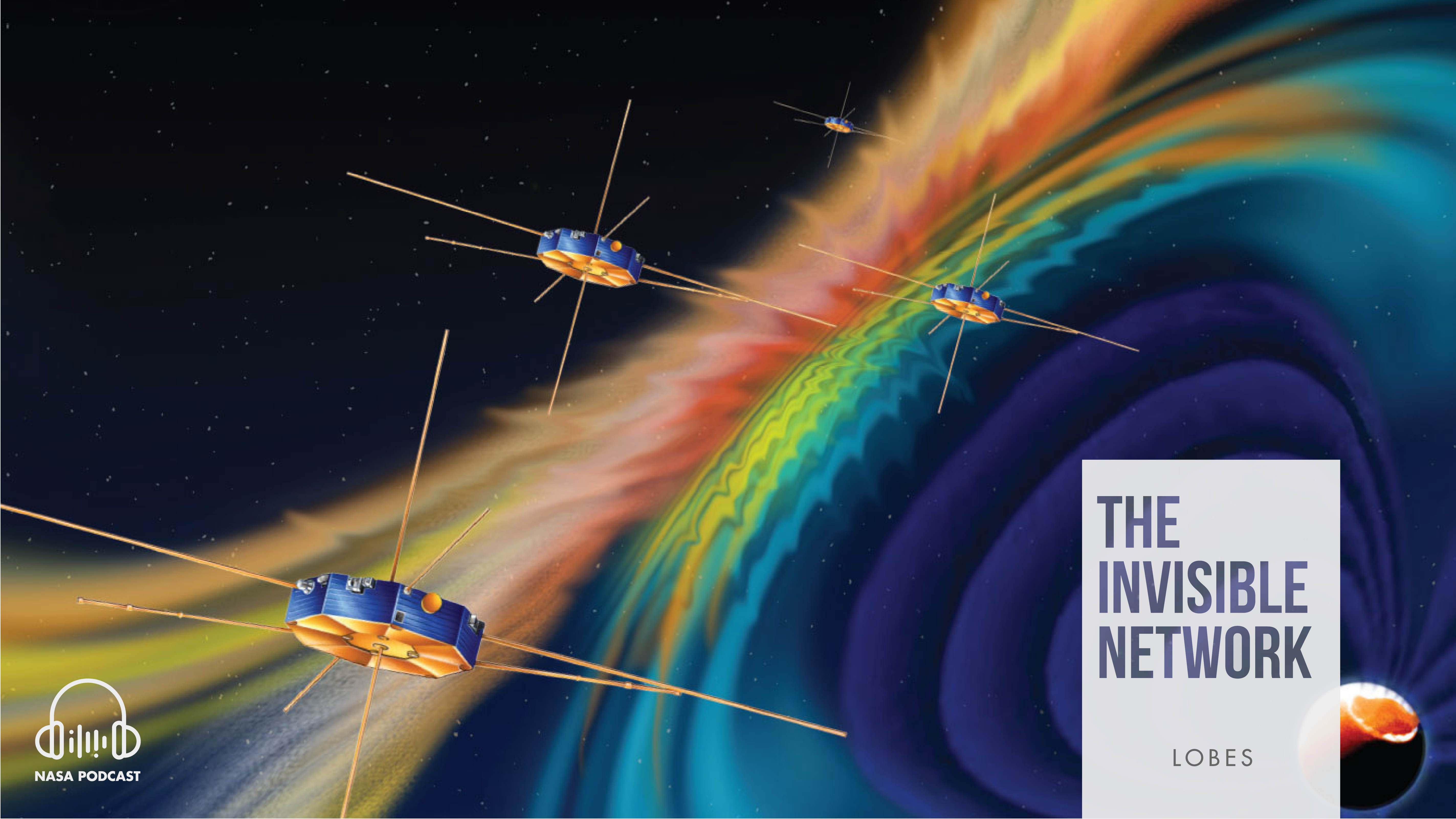
Magnetic reconnection is a fundamental process that occurs throughout the universe in which magnetic fields collide and explosively release particles in all directions.
Near Earth, reconnection is a key driver of space weather, the dynamic system of energy, particles and magnetic fields around Earth that can adversely impact communications networks, electrical grids and GPS navigation. Understanding magnetic reconnection enables scientists to better predict and respond to space weather, ensuring the safety and continued performance of vital infrastructure.
Magnetic reconnection in space had been predicted but never directly observed in minute detail, until MMS.
Magnetospheric Multiscale, or MMS, spacecraft maintain a highly elliptical orbit around Earth. A highly elliptical orbit resembles a long oval around the globe with an extreme high point, or apogee, and low point, or perigee. There are four of these spacecraft, usually flying in tetrahedral formation — sort of an awkwardly shaped pyramid. That tetrahedral formation has allowed the spacecraft to observe magnetic reconnection around Earth.
But, that tight formation and highly elliptical orbit require extremely accurate navigation data.
To provide MMS with the PNT data they needed, navigation engineers looked to GPS. Since the satellites would be flying through areas of dense radiation far from the relative safety of low-Earth orbit, these engineers had to develop a new type of weak signal, radiation-hardened GPS receiver.
They dubbed this instrument “The Navigator.”
The Navigator, developed at Goddard, can detect faint GPS signals while withstanding the harsh radiation environment of the magnetosphere, where magnetic reconnection occurs. After its success on MMS, NASA made the revolutionary technology available for licensing through the Technology Transfer program, which ensures that commercial enterprise can benefit from NASA innovations.
Luke Winternitz was one of the engineers who helped develop the Navigator.
LUKE WINTERNITZ
Navigator is our GPS receiver that we developed. Spaceborne GPS receivers were recognized as a useful technology almost as soon as GPS — the system itself — came on for terrestrial users.
And so, our group got into GPS receiver development early on, in the late ’90s. There was an interest in this application of high-altitude GPS, which was really pushing the envelope of what could be done. They had a receiver they called the PiVoT that was really a low-Earth orbit receiver that they modified. It was actually a commercial chip-set for terrestrial applications I think that was modified for space and then modified again to do some high-altitude testing.
Some of the challenges of high-altitude, that once you go up above the GPS constellation — or even close to the GPS constellation — the signal environment gets different. The signals are weaker, you start to see much sparser visibility. So, once you go above the constellation, you don’t see the main lobe of the signal so much. You may see part of that main lobe transmission that gets past the Earth when the transmitter is on the opposite side. But, you can also see these side lobe signals, which are much weaker.
So, you have less visibility, weaker signals and the geometry could be much worse if you’re way high up.
So, back to Navigator: they had done some testing with this PiVoT receiver and then decided to start this program to develop a receiver from scratch that was targeting these applications. So, that’s what the Navigator was.
NARRATOR
When the four MMS satellites launched in 2015, the mission’s navigation team expected the spacecraft to receive enough GPS signals for reliable PNT as the spacecraft rounded their way through their perigee, underneath the orbits of GPS satellites. Farther away, they thought they might get a little PNT data, but not necessarily enough to determine MMS’ position.
They were pleasantly surprised — to say the least.
On Oct. 20, 2016, MMS won the Guinness World Record for the highest altitude GPS fix ever recorded at its 43,500-mile apogee. After an orbit change in 2017, to study a different area of the magnetosphere, the spacecraft nearly doubled that record, receiving enough GPS signals to determine its position a whopping 93,200 miles from Earth.
This past February, MMS shattered its own record for a third time. MMS now reaches over 116,300 miles from Earth at the highest point of its orbit. That’s about halfway to the Moon. At this immense distance from Earth, MMS could still “see” enough GPS side lobe signals to calculate its position.
Trevor Williams, MMS flight dynamics lead, explains in more detail:
TREVOR WILLIAMS
We measure everything in terms of Earth radius, you know, RE. GPS is like four RE. We’re up at, say, 29 right now — the highest point of the orbit is 29. The Moon is at 60, so we’re halfway to the Moon! So, we’re way above GPS.
NARRATOR
Thanks to MMS and NASA’s navigation engineers, the sky is no longer the limit. If MMS can use GPS signals for PNT data so far away from Earth, what could signals from all the GNSS constellations provide?
Well, NASA simulations show that GNSS signals could even be used for reliable navigation in lunar orbit. Just as you might use GPS to navigate an unknown city, upcoming crewed lunar missions could use GNSS to fly their way around the Moon. The navigation architecture for the future Gateway, an outpost set to orbit around the Moon, will rely on GNSS signals. Thus, GNSS will enable NASA’s goal of sustained lunar surface exploration.
Ben Ashman runs many of these simulations, proving that GNSS can be a vital piece of the Artemis missions to establish a sustained presence at the Moon. He sometimes drives a cherry-red scooter to work, plays keys in several D.C. bands and repairs pinball machines on the weekends.
BEN ASHMAN
Operationally, we’ve used GPS up to about 29 Earth radii. However, although this is the highest altitude that’s been demonstrated, we believe that it’s possible to use these signals even farther. There’s obviously been a lot of attention lately on going to the Moon, and there are plenty of opportunities to use GNSS signals on the way to the Moon and, perhaps, even at the Moon.
We’ve got the flight data from MMS at those high altitudes and we’re able to extrapolate that to these higher altitudes, and the results look good. It looks very promising that there would be sufficient signals available all the way out at that distance to perform GPS-based navigation — if not solely using GPS or some other GNSS constellation, at least to include that as a component of the overall navigation approach.
…
NARRATOR
GNSS aren’t NASA satellites, but the U.S. has a vested interest in their continued operation. In order to ensure that signals from these constellations continue to be a robust option for spacecraft, NASA PNT experts work alongside other U.S. agencies, like the U.S. Air Force and the State Department, to foster collaboration between the GNSS service providers. NASA PNT experts also assist the United Nations International Committee on GNSS, serving as subject matter experts on high altitude GNSS and advocating for NASA.
Prague. Munich. Sochi. Vienna. Kyoto.
Maps neatly frame Joel Parker’s desk. Each creased leaflet marks a conference conducted — a milestone crossed. He collects one for every city he visits while representing NASA at the committee’s meetings.
JOEL PARKER
We work directly with the United Nations International Committee on GNSS, which is a body that brings together GNSS and regional systems specifically to talk about interoperability, compatibility, new features, requirements, things like that.
We meet a couple times a year. All the systems are involved and working collaboratively to maximize the utility of their systems. There’s a specific group there called the Space Users Group that focuses specifically on users of GPS and GNSS that are in orbit.
The U.N. office that runs it is based in Vienna, Austria, but the meeting tends to travel every year to a different host city and host country — most of the time from an operator of a GNSS system. So, we get a lot of international travel out of our meetings.
NARRATOR
James Miller, affectionately known as JJ, is NASA’s lead for PNT policy. He coordinates NASA’s collaboration with the Department of State and the United Nations International Committee on GNSS, promoting GNSS interoperability and compatibility, key to ensuring robust navigation services on Earth, as well as in space.
J.J. MILLER
Working with the international community is probably one of the most rewarding things that you can possibly do in this geopolitical environment. In the same way that the International Space Station became symbolic of how our nations can come together for the greater good, working GNSS applications through the United Nations, specifically the International Committee on GNSS, has allowed us to do exactly the same.
…
NARRATOR
The math used to calculate a location based on GPS and GNSS satellite signals is called “trilateration.” Essentially, one imagines gigantic spheres extended out from GNSS satellites with radii equal to a distance calculated from the time it takes your device to receive their signals. It sounds complicated because it is.
Beyond trilateration, engineers must account for other issues, each adding additional layers of math to the tiramisu of equations that enable GNSS navigation. There’s reflection and refraction of the signals in the atmosphere; there’s accounting for minute errors in the insanely accurate clocks on board GNSS satellites; there’s even the dilation of time due to gravity. All of these add complexity.
Katie Schauer and I spent hours trying to develop example trilateration problems for our navigation workbook. I filled pages of graph paper with incomprehensible scribbles, praying to Pythagoras and chanting “PEMDAS” as we worked. Even working with the relatively simple questions we were using as examples, we struggled.
So, we sat down with Ben Ashman and Joel Parker to get it right. With them, the math made sense. More importantly, the problems were exciting. If I’m being honest, I’m still not entirely sure I could do a trilateration problem on my own — even an easy one. But, thanks to Ben and Joel, Katie and I have a grasp on how everything works, and found joy in it.
Math in the abstract can be a terrifying proposition, but, when Ben and Joel break it down, it isn’t. That’s thanks, at least in part, to the context they provide. One of my favorite parts of working with NASA engineers is hearing about what they do in the context of who they are. It rounds out their work, coloring math and science with their unique passions and interests.
I’ve seen Joel’s desk surrounded by maps. He’s just as excited about travelling the world as he is about GNSS policy. I’ve seen Ben on his scooter. He’s just as fascinated by the possibilities of lunar GNSS as he is by the inner workings of pinball machines.
How could math be scary when it’s conquered by such interesting people?
…
This season of “The Invisible Network” debuted in November of 2019. The podcast is produced by the Space Communications and Navigation program, or SCaN, out of Goddard Space Flight Center in Greenbelt, Maryland. Episodes were written and recorded by me, Danny Baird, with editorial support from Matthew Peters. Our public affairs officers are Peter Jacobs of Goddard’s Office of Communications, Clare Skelly of the Space Technology Mission Directorate and Kathryn Hambleton of the Human Exploration and Operations Mission Directorate.
Special thanks to Barbara Adde, SCaN Policy and Strategic Communications director, Rob Garner, Goddard Web Team lead, Amber Jacobson, communications lead for SCaN at Goddard, and all those who have lent their time, talent and expertise to making “The Invisible Network” a reality. Be sure to rate, review and subscribe to the show wherever you get your podcasts. For transcripts of the episodes, visit NASA.gov/invisible. To learn more about the vital role that space communications plays in NASA’s mission, visit NASA.gov/SCaN.