


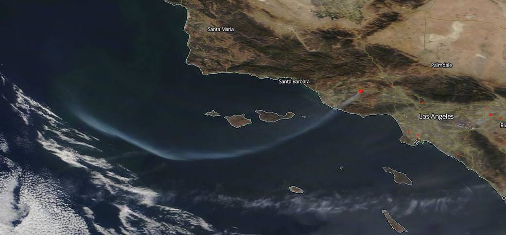

NASA’s Aqua and Terra satellites captured two separate images of the fires in California on October 30, 2019. Aqua captured the northern Kincade Fire and Terra captured the southern Getty Fire with its smoke plume swoosh off the coast of California. The Kincade Fire (bottom image) in northeast of Geyserville in Sonoma County, California, has burned 76,825 acres but firefighting efforts have been heroic during past 24 hours stanching the fire’s growth and bringing fire containment to 60% as of 7:00 am PDT. Firefighters were dealing with better weather conditions that were expected near the Kincade fire. In Los Angeles County, too, the Getty Fire (top image) has a containment level of 39% of the fire from a containment level of 5% just yesterday, Oct. 30. The Getty fire has grown less than 100 acres in the past 24 hours even with the threat of the Santa Ana winds that were predicted to reach gale force winds overnight.
To date the Kincade fire has been a devastating one displacing hundreds of thousands of residents due to mandatory evacuations and threatening upwards of 90,000 structures. As of Oct 31, 266 structures have been destroyed in the Kincade fire and 90,015 structures are still threatened. The Getty fire is smaller in size but is still extremely dangerous because it is in such a populated area. The Los Angeles Fire Department reported that: “Firefighters worked overnight to cool any hot spots and contain any flare ups within the current fire perimeter. Adverse weather conditions will continue to be the greatest challenge for firefighters. An Extreme Red Flag Warning remains in effect through 6:00 p.m. PDT. Strong Santa Ana winds with peak wind gusts of 30-50 mph will continue to impact wind prone areas of Los Angeles. Widespread single digit relative humidity’s are forecasted. This all adds up to an extreme fire weather threat, meaning that conditions are as dangerous for fire growth and behavior as we have seen in recent years.” Investigators have been able to determine the preliminary cause of the fire by using burn patterns, witness statements, and physical evidence. The fire was deemed an accidental start, caused by a tree branch that broke off and subsequently landed in nearby powerlines during high wind conditions. This errant tree branch caused the sparking and arcing of powerlines, igniting nearby brush. All powerlines on the pole remained intact. The Getty fire is still threatening 7,091 residences. Twelve residences have been destroyed. Thousands of people have been evacuated.
NASA’s satellite instruments are often the first to detect wildfires burning in remote regions, and the locations of new fires are sent directly to land managers worldwide within hours of the satellite overpass. Together, NASA instruments detect actively burning fires, track the transport of smoke from fires, provide information for fire management, and map the extent of changes to ecosystems, based on the extent and severity of burn scars. NASA has a fleet of Earth-observing instruments, many of which contribute to our understanding of fire in the Earth system. Satellites in orbit around the poles provide observations of the entire planet several times per day, whereas satellites in a geostationary orbit provide coarse-resolution imagery of fires, smoke and clouds every five to 15 minutes. For more information visit: https://www.nasa.gov/mission_pages/fires/main/missions/index.html
NASA’s Earth Observing System Data and Information System (EOSDIS) Worldview application provides the capability to interactively browse over 700 global, full-resolution satellite imagery layers and then download the underlying data. Many of the available imagery layers are updated within three hours of observation, essentially showing the entire Earth as it looks “right now.” Actively burning fires, detected by thermal bands, are shown as red points. Image Courtesy: NASA Worldview, Earth Observing System Data and Information System (EOSDIS). Caption: Lynn Jenner with information from CAL Fire and the Los Angeles Fire Department website.