


Enrique (Eastern Pacific)
Although it appeared that Tropical Storm Enrique had weakened to a tropical depression, satellite data revealed that there was still some punch left in the system and it was re-classified a tropical storm on July 17. Scatterometer data from Europe’s METOP satellite and NASA’s RapidScat instrument confirmed those tropical-storm-force winds were occurring in one part of the storm.
National Hurricane Center Forecaster Pasch noted on July 17, 2015 at 5 a.m. EDT, “Data from a recent ASCAT overpass showed that Enrique had not weakened quite as much as earlier estimated, and that there were still tropical storm force winds over the northwest quadrant of the cyclone.” ASCAT-A is the Advanced Scatterometer that flies aboard Europe’s EUMETSAT METOP satellite. ASCAT uses radar to measure the electromagnetic backscatter from the wind-roughened ocean surface, from which data on wind speed and direction can be derived. These products are processed by NOAA/NESDIS utilizing measurements from ASCAT. “The current intensity estimate is set at 35 knots resulting in the re-designation of the system as a tropical storm,” Pasch said.
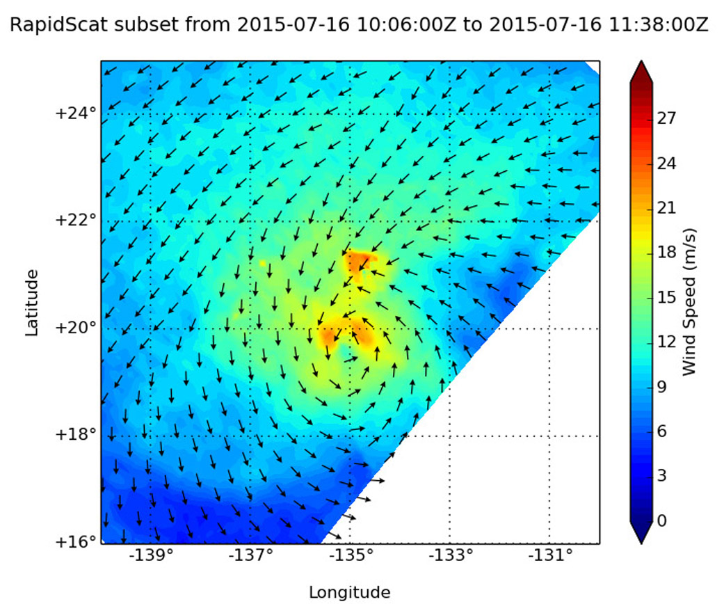
On July 16, RapidScat saw the Enrique’s strongest sustained winds were near at 21 meters per second (m/s) (46.9 mph/ 75.6 kph) and just north of the center of circulation. When RapidScat analyzed the surface winds again on July 17 at 10 a.m. GMT (6 a.m. EDT), they were still at the same speed, and just north-northwest of the center of circulation.
At 5 a.m. EDT on July 17, the center of Tropical Storm Enrique was located near latitude 20.6 North and longitude 136.8 West, about 1,730 miles (2,785 km) west of the southern tip of Baja California, Mexico. Enrique was moving toward the west-northwest near 6 mph (9 kph and is expected to turn to the west-southwest. Satellite wind data indicate that the maximum sustained winds are near 40 mph (65 kph) with higher gusts.
Enrique should be traversing waters cooler than 25 degrees Celsius (77 Fahrenheit) and entraining rather stable air. Therefore, weakening is still anticipated and the system is forecast to degenerate into a remnant low by sometime on July 18.
Rob Gutro
NASA’s Goddard Space Flight Center
July 16, 2015 – RapidScat Shows Enrique Holding Tropical Storm Status
The National Hurricane Center deemed that the Eastern Pacific Ocean’s tropical cyclone Enrique continued to hold onto tropical storm status during the morning of July 16, based on surface wind data from NASA’s RapidScat instrument.
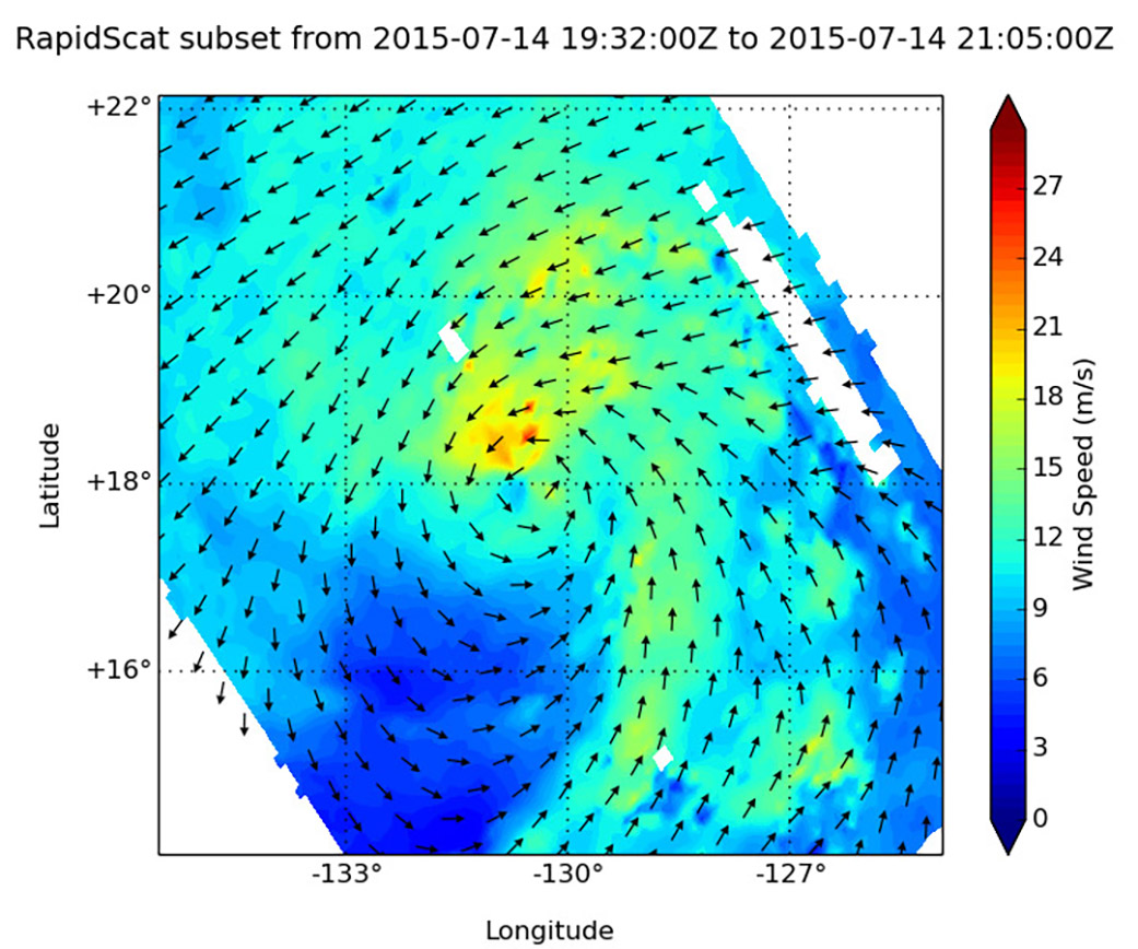
On July 14, RapidScat saw the Enrique’s strongest sustained winds were near at 21 meters per second (m/s) (46.9 mph/ 75.6 kph) and just north of the center of circulation. Two days later, on July 16, 2015 at 11 a.m. EDT, National Hurricane Center forecaster Jack Beven cited RapidScat data in the hurricane forecast. Beven said, “While the convection associated with Enrique continues to decrease, data from the RapidScat instrument on the International Space Station suggest the system still had tropical storm force winds.
At 11 a.m. EDT (1500 UTC) on July 16 the center of Tropical Storm Enrique was located near latitude 19.9 North, longitude 135.5 West. About 1,655 miles (2,665 km) west of the southern tip of Baja California, Mexico. Maximum sustained winds are near 40 mph (65 kph).The estimated minimum central pressure is 1004 millibars.
Enrique is moving toward the west-northwest near 8 mph (13 kph), and this general motion is expected to continue today. A turn toward the west at a slower forward speed is expected on Friday, July 17.
Beven noted that Enrique is encountering cool sea surface temperatures and a drier air mass. That combination is expected to lead to weaken the storm to a remnant low pressure area in the next day or two.
Rob Gutro
NASA’s Goddard Space Flight Center
July 15, 2015 – NASA Sees Tropical Storm Enrique Enter Cooler Waters, Weaken
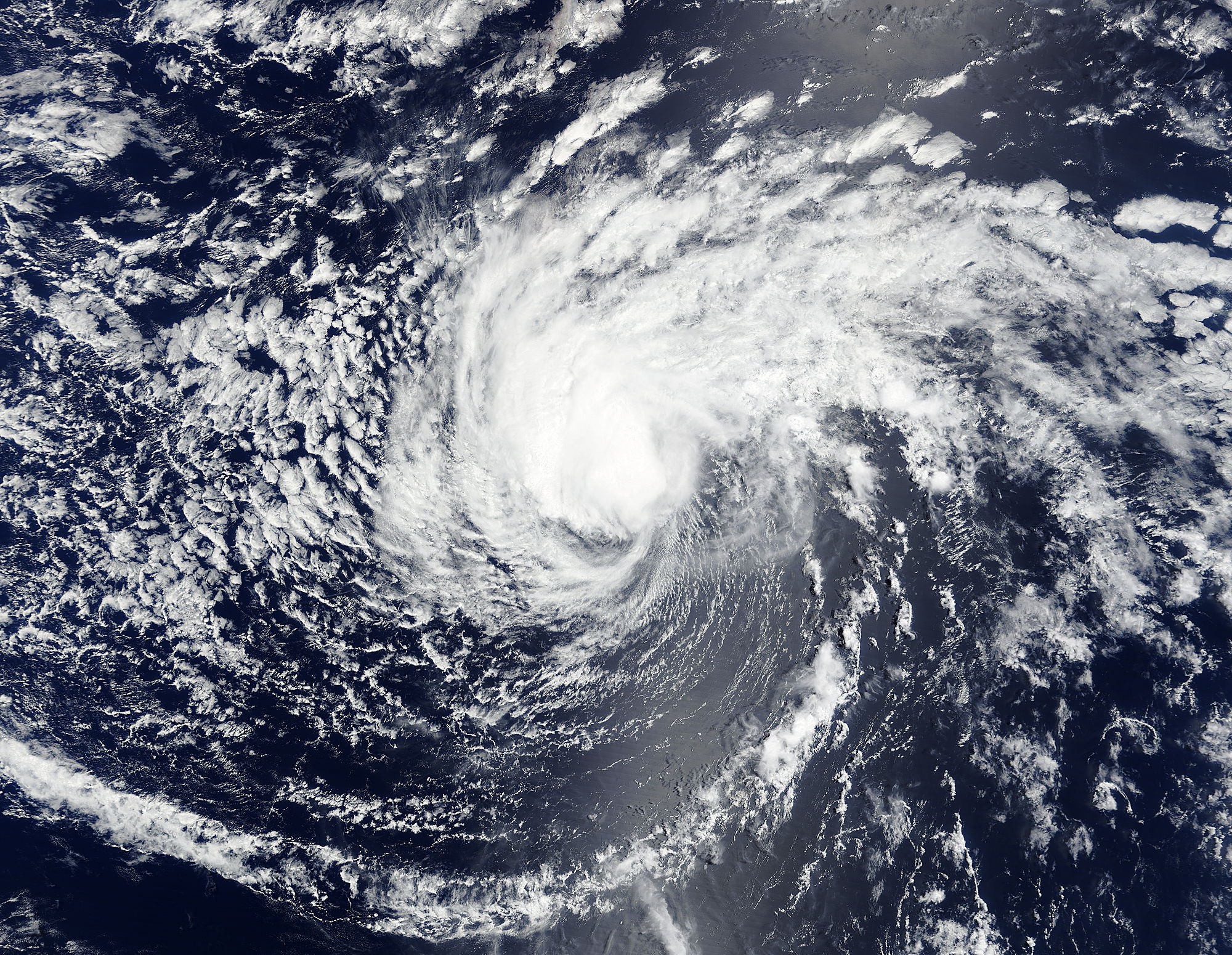
Tropical cyclones need sea surface temperatures of at least 80 degrees Fahrenheit (26.6 Celsius) to maintain strength, and a new infrared image from NASA’s Aqua satellite shows that Tropical Storm Enrique has moved into an area where temperatures are under that threshold.
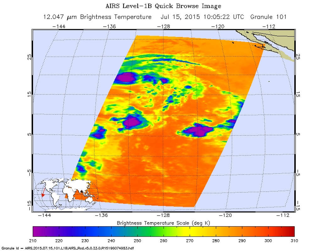
NASA’s Aqua satellite passed over Tropical Storm Enrique on July 15 at 10:55 UTC (6:55 a.m. EDT) and the Atmospheric Infrared Sounder or AIRS instrument aboard gathered infrared data on the storm’s clouds and surrounding sea surface temperatures. AIRS found that cloud top temperatures had warmed indicating less uplift in the system and weakening. Conversely, AIRS also found that the sea surface temperatures were near 77 Fahrenheit (25 Celsius). The infrared image was created at NASA’s Jet Propulsion Laboratory in Pasadena, California and false-colored to show temperatures.
At 11 a.m. EDT /8 a.m. PDT (1500 UTC) on July 15 the center of Tropical Storm Enrique was located near latitude 19.0 North, longitude 132.9 West. About 1,505 miles (2,425 km) west of the southern tip of Baja California, Mexico. Enrique was moving toward the west-northwest near 8 mph (13 km/h), and this general motion is expected to continue until dissipation in a couple of days. Maximum sustained winds have decreased to near 45 mph (75 kph) with higher gusts.
The National Hurricane Center noted that Enrique has reached cooler waters and weakening is anticipated over the next two days.
Rob Gutro
NASA’s Goddard Space Flight Center
July 14, 2015 – A Satellite View of Tropical Storm Enrique
NOAA’s GOES-West satellite provided an infrared view of Tropical Storm Enrique on July 14 as it continues to track west through the Eastern Pacific Ocean.
GOES-West provided an infrared image of Enrique at 1200 UTC (8 a.m. EDT) that showed a concentration of thunderstorms around the center of circulation.
The National Hurricane Center’s forecaster Daniel Brown noted on July 14 that “Deep convection associated with Enrique has increased in coverage overnight, however, the overall organization of the system has not changed appreciably.”
At 5 a.m. EDT (0900 UTC) on July 14, the center of Tropical Storm Enrique was located near latitude 17.3 North, longitude 129.0 West. About 1295 miles (2,085 km) west-southwest of the southern tip of Baja California, Mexico. There are no coastal watches or warnings in effect.
Enrique is moving toward the west-northwest near 9 mph (15 kph) and this motion is expected to continue during the next couple of days. Maximum sustained winds are near 40 mph (65 kph) with higher gusts. The estimated minimum central pressure is 1003 mb (29.62 inches).
The National Hurricane Center expects little change in strength during the next day or so. After that time, Enrique is expected to weaken while it moves into an area of increasing southerly wind shear and over cooler waters.
Rob Gutro
NASA’s Goddard Space Flight Center
July 13, 2015 – NASA’s Terra Satellite Sees Formation of Tropical Storm Enrique
When NASA’s Terra satellite passed over Tropical depression 6E on July 12 at 19:05 UTC (3:05 p.m. EDT), the MODIS instrument captured a visible-light image that showed the bulk of clouds and showers were banding southwest of the center.
Forecaster Blake of the National Hurricane Center (NHC) noted on July 13 at 5 a.m. EDT, “Satellite images indicate that the cyclone has become a bit better organized with a growing curved band in the southern semicircle and more persistent convection near the center.” At that time, NHC designated Tropical Depression 6E as a tropical storm.
At 5 a.m. EDT (0900 UTC), Tropical Depression 6E strengthened into Tropical Storm Enrique. At that time, Enrique was located near latitude 15.2 North, longitude 126.4 West. About 1200 miles (1,930 km) west-southwest of the southern tip of Baja California, Mexico. Enrique was moving toward the northwest near 10 mph (17 kph). A northwestward to west-northwestward motion is expected during the next couple of days. Maximum sustained winds have increased to near 40 mph (65 km/h) with higher gusts. Some strengthening is forecast during the next day or two. The estimated minimum central pressure is 1001 millibars.
The tropical storm has a day or two to strengthen before it moves into an area of cooler sea surface temperatures, drier air, and higher vertical wind shear all of which are factors that weaken tropical cyclones. In addition, NHC noted that the long-range forecast is rather uncertain due to possible interactions with both Tropical Storm Dolores to the east and a mid-latitude trough (elongated area of low pressure) to the north.
Rob Gutro
NASA’s Goddard Space Flight Center