


In a decade filled by record-breaking events including raging wildfires, numerous hurricanes, unseasonal flooding and historically cold temperatures, NASA has continued to learn more about how the planet is changing and the effect it has on Earth’s systems.
In the satellite era, a fleet of Earth-observing satellites have gathered data on world-wide rain and snowfall, air and ocean temperatures, air quality, land use and land cover, along with a myriad of other phenomena that enable researchers and decision makers to study the connections between changes in climate, environment and society. For vulnerable communities these changes can create new risks.
Scientists use a number of databases to measure different facets of the Earth system, from surface temperature to humidity levels. NASA’s Earth Observing System Data and Information System (EOSDIS) provides long-term data records that can help with climate research.
NASA Earth Science funds innovative applied research to help communities anticipate and prepare before disasters strike and provides data products and expertise to stakeholders that enable early action, increase situational awareness during response and aid recovery efforts.
Floods, Fires and Hurricanes
The water from melting ice sheets in Greenland and Antarctica doesn’t stay at the poles. Meltwater enters the ocean and contributes about one-third of the total global sea level rise. For people living in low-lying coastal communities, this means an increased vulnerability to flooding.
Whether from sea level rise, heavy rainfall and extreme weather events or over-flowing rivers, floods affect more people worldwide than any other type of natural disaster. Climate change has begun to shift the pattern of rainfall around the world, and as a result the frequency and intensity of floods are increasing in many areas. NASA uses remote sensing to find vulnerabilities and flooding risks among communities. Satellite observations can help local communities understand the factors that cause floods, respond to them in real-time, and mitigate their impacts when they occur.
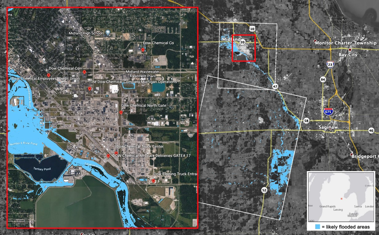
In 2020 NASA data aided response efforts for several significant flood events in the United States and abroad. One was the May 2020 flooding in Midland County, Michigan, that resulted from the failure of the Edenville and Sanford Dams. NASA provided detailed flood maps to help local decision-makers prioritize their response. In November 2020, Hurricanes Eta and Iota brought heavy rainfall, floods and landslides to Central America. NASA worked with U.S. Southern Command (SOUTHCOM), providing satellite-based maps to identify likely damage to infrastructure, and other data products to support flood assessment and recovery efforts for emergency humanitarian assistance and disaster relief planning.
Floods affect remote communities as well as well-populated ones. Mountain glaciers world-wide are melting and retreating, creating new risks for people living downhill. As glaciers retreat, they leave in their wake glacial lakes formed from their meltwater and dammed by sediments and ice. Recent research using data from the NASA-U.S. Geological Survey Landsat mission has shown that the volume of glacial lakes has increased by 50% since 1990.
These lakes are prone to glacial lake outburst floods, which occur when relatively unstable dams collapse and a sudden burst of water roars downstream. Over the last century, these outburst floods have destroyed villages, infrastructure and livestock in mountainous regions around the world, as well as killed thousands of people. Glacial lake outburst floods can also be triggered by landslides, avalanches, volcanic eruptions, or earthquakes.
Climate change combined with human activity has also set the stage for more intense wildfires. In 2020, massive wildfires spread across Australia, the American West and Siberia. In addition to the devastation to local communities and ecosystems, the effects of fires can be felt hundreds and thousands of miles away as smoke travels on the winds. Particulates in smoke are a serious health concern since they can irritate lungs and cause respiratory problems, especially for people with asthma. According to the World Health Organization (WHO), air pollution is the cause of roughly 4.2 million deaths per year.
Smoke can also affect other parts of the Earth system. For example, during the 2019-2020 Australian fires, NASA’s Sage III instrument saw a spike in aerosols – tiny airborne particles of dust and ash – higher in the atmosphere than Earth-observing instruments usually measure them. Behaving more like the particles ejected into the air from a moderate volcanic eruption, the high altitude reach of the aerosols in the atmosphere means that they were likely to stay in the air longer before settling out to the surface. Research using additional NASA satellite data shows they had an effect on Earth’s energy balance by blocking sunlight.
While NASA researchers use satellite data to better understand the connections between climate and fires – and how fires affect the climate – they also use that data to develop tools for local agencies to track active fires and their smoke plumes, and aid in recovery efforts.
These efforts also extend to hurricanes. As the 2020 Atlantic hurricane season smashed records with an unprecedented 30 named storms, NASA collaborated closely with stakeholders from the Federal Emergency Management Agency (FEMA), the Louisiana National Guard, SOUTHCOM, and many others.
These efforts are increasingly important since the intensity of hurricanes and other extreme weather events is expected to rise in a changing climate. Warmer ocean temperatures due to climate change feed a storm’s heat engine and can propel it to a Category 5. Warmer ocean temperatures in the North Atlantic may also be leading to a decline in one of the factors that puts the brakes on hurricane formation – dry dusty air from the Sahara that can act as a dehumidifier and may occasionally prevent gathering clouds and wind from coalescing into a tropical storm or hurricane.
Before, during and after disasters strike, NASA connects Earth data with decision-makers, private-sector interests and local governments, providing actionable data to recover from disaster impacts.
As disasters become more frequent and intense, NASA’s unique view from space on our changing world provides the information that connect people to technology to build a more resilient world.
Banner image caption: An image of the United States and Central America from September 2020, showing fires and their smoke in the west, several hurricanes converging, and Hurricane Sally making landfall. The true-color image was taken by NOAA/NASA’s Suomi NPP satellite.