


On Friday, Oct. 11, the OSIRIS-REx team should have been preparing to point their spacecraft cameras precisely over the asteroid Bennu to capture high-resolution images of a region known as Osprey. It is one of four sites scientists are considering from which the spacecraft can safely collect a sample in late 2020.
But early that morning, the team learned that a telecommunications facility near Madrid had suffered an unexpected network outage. Part of NASA’s Deep Space Network (DSN) of global spacecraft communications facilities, the Spanish complex is home to giant radio antennas. One of these was scheduled to ping OSIRIS-REx for a critical data download.
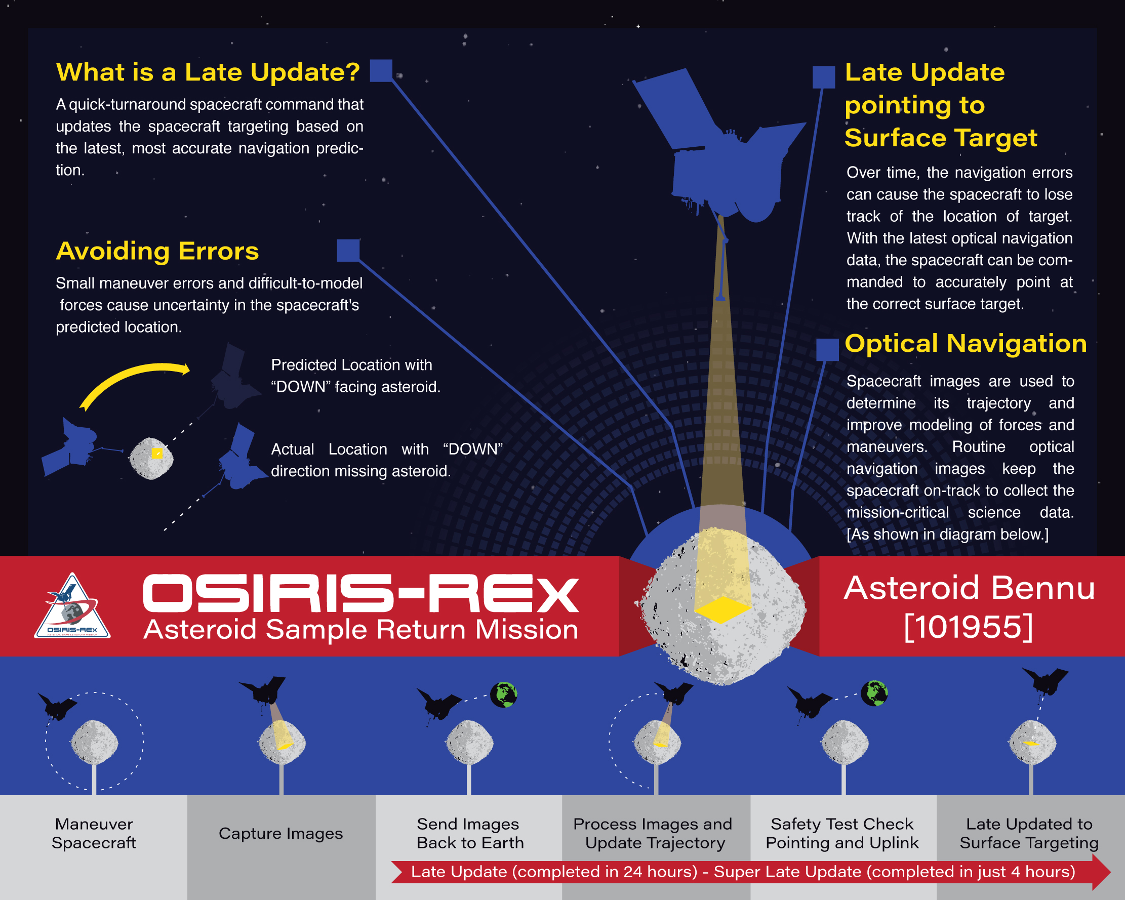
The data download would have kicked off a 24-hour marathon process known as a “late update” to predict the spacecraft’s trajectory in time for a flyover of Osprey. Among the litany of complex tasks the navigation team needed to do that day was to download images of Bennu. The team uses these images to identify landmarks on the asteroid in order to update the spacecraft’s position and velocity.
But the DSN outage threatened to throw the mission off track.
The OSIRIS-REx team identified Osprey as one of the most promising sites on Bennu’s rugged surface, based on its relatively smooth terrain and lack of large, potentially hazardous boulders. Osprey is set inside an approximately 66-foot- (20-meter-) wide crater near Bennu’s equator.
On Oct. 12, engineers were planning to collect critical images of the surface in order to assess Osprey’s population of rocks that might be small enough to be ingested into OSIRIS-REx’s sample collection head when the spacecraft ultimately touches Bennu next year. This assessment was the key piece of information the team needed to choose the top sample collection site from the final four.
The Osprey flyover was the second of the four sites to be surveyed during the reconnaissance campaign. It would bring the spacecraft a little more than half a mile, or 1 kilometer, from Bennu’s surface. The missed opportunity to download the images of Bennu on Oct. 11 meant that there would not be enough time to follow the usual 24-hour process to update the spacecraft position at the time of the critical observations. This update is required for the spacecraft’s cameras to be pointed correctly at Osprey on Oct. 12.
Missing the Osprey observations would have set off a domino effect of delays, said Kenneth Getzandanner, OSIRIS-REx flight dynamics manager based at NASA’s Goddard Space Flight Center in Greenbelt, Maryland. “We knew that if we didn’t get the Osprey data, we wouldn’t be able to make the decision about our top sites for sample collection.”
Not selecting a sample site would have meant postponing the mission’s headlining event next year: the few hours of nail-biting action the team calls TAG, which stands for “Touch-And-Go.” During TAG, the spacecraft will deploy its robotic arm, dip to the surface of Bennu, and collect a sample of dirt and rocks, or regolith in scientific terms, from Bennu. Ultimately, the spacecraft will deliver a capsule with the sample to Earth, dropping it in the Utah desert in September 2023.
Credits: NASA/Goddard
To scientists around the globe, the primitive gravel from Bennu is a porthole to the early solar system, when asteroids may have played a role in delivering life-forming compounds to Earth. Delaying this monumental mission — one of the most ambitious ever attempted — would be costly and demoralizing to scientists.
So OSIRIS-REx engineers quickly hatched a daring plan.
“Typically, a dropped DSN pass would not cause such a scramble, but the critical nature of the images made us realize we needed to take action immediately,” said Brennen Miller, a systems engineer from Lockheed Martin Space Systems in Littleton, Colorado.
The 24-hour trajectory update process is already ambitious compared to other missions. But the team decided to squeeze this entire procedure into less than four hours to keep their mission timeline intact. That procedure would have to occur on Oct. 12, the next window of opportunity they’d have to downlink the key images from the spacecraft.
On Oct. 11, engineers practiced their new, ultra-quick routine that they dubbed “super late update.” It hinged on each team member, like a relay racer, standing by for their turn to help execute the plan with ruthless efficiency.
“People were pretty nervous about compressing the 24-hour timeline,” said Richard Burns, the Goddard-based OSIRIS-REx project manager, “but the team was well practiced at performing late updates, so we knew we had the right people and the right tools to make it happen.”
Flying a spacecraft within a kilometer of a small body like Bennu requires ultimate precision. Since engineers can’t see their spacecraft in space, they often rely on DSN antennas to collect signals that allow them to determine its speed and location. But tracking through the DSN is not precise enough for a spacecraft that’s both far from Earth (more than 155 million miles, 250 million kilometers) and needs to get very close to a planetary body, as was the case with OSIRIS-REx and Osprey.
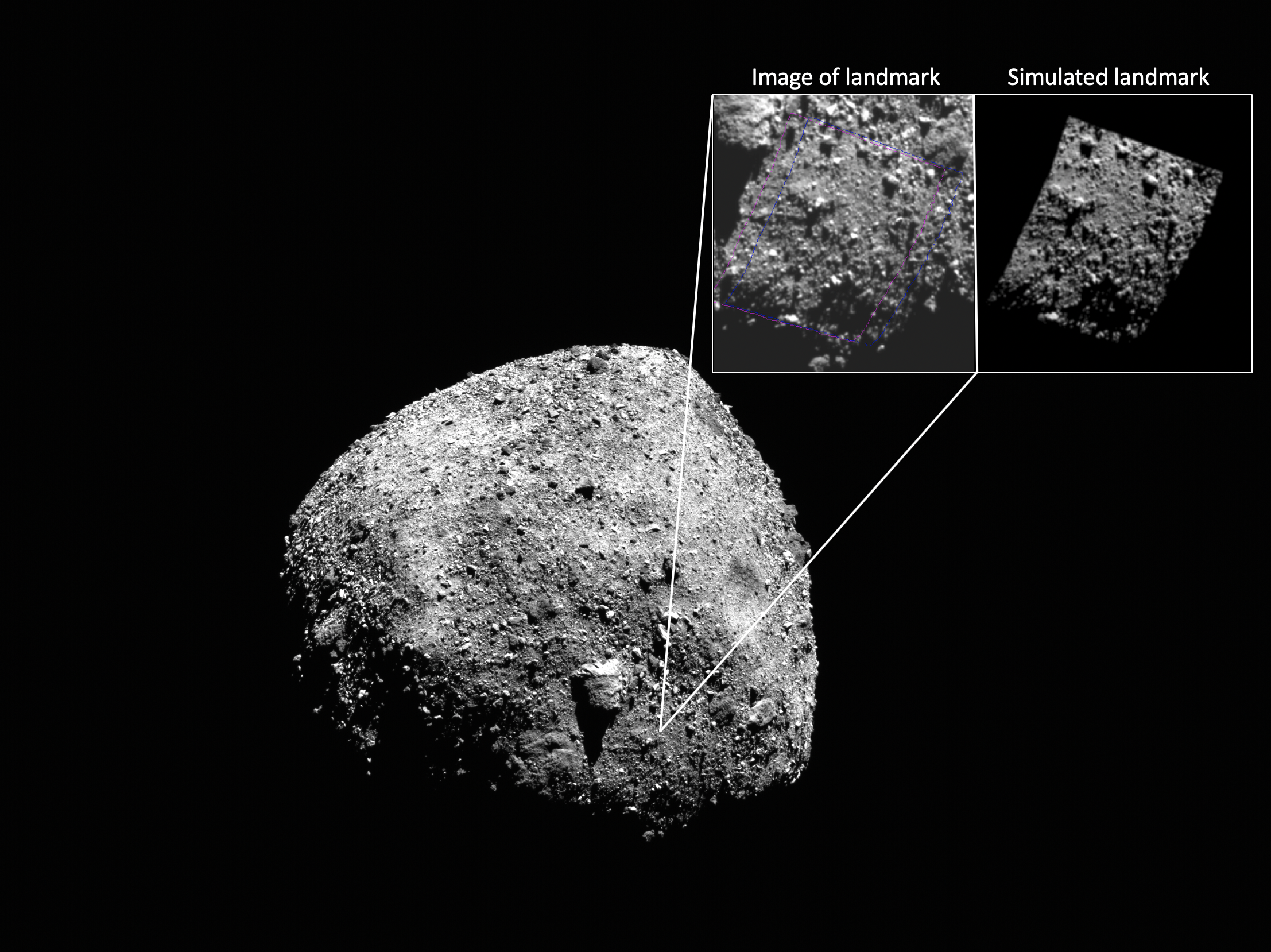
For such close encounters — the closest that any spacecraft has orbited its celestial object of study — OSIRIS-REx engineers relied on images of Bennu’s surface taken by the spacecraft’s cameras in a technique known as optical navigation. Unique landmarks in the images, such as boulders and craters, help reveal where the spacecraft is located in relation to the asteroid. Together with sophisticated mathematical models that take into account forces such as the slight pull of Bennu’s gravity or the slight push of radiation from the Sun, these images allow engineers to predict where the spacecraft is headed, and ultimately where it’ll have to point its cameras when a region of interest is being observed. But the predictions aren’t perfect. With each burn of the engine, for instance, the spacecraft can boost itself farther or closer than anticipated.
“Most missions aren’t that sensitive to small changes in position, but this one is because we’re so close to the asteroid that small changes in position result in big changes in where you want to be pointed, particularly when you want to be pointed at a really small patch of the asteroid such as Osprey,” said Burns.
Having pulled off dozens of detailed observations under these constraints earlier in the mission, the OSIRIS-REx engineers, like highly trained athletes with fine-tuned motor skills, were able to complete the compressed procedure. On Oct. 12, they sent the updated positions to the spacecraft and waited for the resulting images of Osprey. As the images materialized, crisp and clear and perfectly centered on Osprey, it was evident that the race had paid off.
“It’s a testament to the preparation and skill of the team that we were able to accomplish this in less than four hours. It speaks to the fact that we have a stellar team as we head into the most critical and challenging phase of this mission: the sample collection campaign,” Burns said.
NASA will announce the primary sample site, as well as a backup, on Dec. 12. Two final reconnaissance flyovers at even lower altitudes beginning in January will allow the OSIRIS-REx team to collect final, detailed images of these sites.

Goddard provides overall mission management, systems engineering, and safety and mission assurance for OSIRIS-REx. Dante Lauretta of the University of Arizona, Tucson, is the principal investigator, and the University of Arizona leads the science team and the mission’s science observation planning and data processing. Lockheed Martin Space in Denver built the spacecraft and is providing flight operations. Goddard and KinetX Aerospace are responsible for navigating the OSIRIS-REx spacecraft. OSIRIS-REx is the third mission in NASA’s New Frontiers Program, which is managed by NASA’s Marshall Space Flight Center in Huntsville, Alabama, for the agency’s Science Mission Directorate in Washington.
By Lonnie Shekhtman
NASA’s Goddard Space Flight Center, Greenbelt, Md.