


Satellite Movie Shows Tropical Cyclone Blas Fading
An animation of visible and infrared imagery from NOAA’s GOES-West satellite from July 9 to July 11 shows Tropical Storm Blas weakening to a remnant followed by a strengthening Tropical Cyclone Celia.
The animation shows that Blas had weakened from a tropical storm to a tropical depression by 5 a.m. EDT (0900 UTC) on Sunday, July 10, 2016. At that time, maximum sustained winds had decreased to near 35 mph (55 kph).NOAA manages the Geostationary Operational Environmental Satellites, and NASA/NOAA’s GOES Project at NASA’s Goddard Space Flight Center in Greenbelt, Maryland uses the data from them to create images and animations.
Credits: NASA/NOAA GOES Project
By 11 a.m. EDT on July 10 Blas was considered a post-tropical storm. At that time, the center of Post-Tropical Cyclone Blas was located near 21.3 north latitude and 136.3 west longitude. The post-tropical cyclone was moving toward the west near 10 mph (17 kph).
By July 11, Blas’ remnants were growing weaker and still moving in a westerly direction in the Eastern Pacific Ocean. The remnants are expected to dissipate in a couple of days.
Rob Gutro
NASA’s Goddard Space Flight Center
July 08, 2016 – NASA Sees Hurricane Blas Closing its Eye
Hurricane Blas is weakening in the Eastern Pacific Ocean and when the Suomi NPP satellite passed overhead visible imagery showed that the eye of the storm had become filled with high clouds. Infrared imagery, however, still revealed a pinhole eye as the eye was becoming cloud-filled.

On July 7 at 21:40 UTC (5:21 p.m. EDT) the Visible Infrared Imaging Radiometer Suite (VIIRS) instrument aboard NASA-NOAA-DOD’s Suomi NPP satellite captured a visible image of Hurricane Blas in the Eastern Pacific Ocean. The image showed that Blas’ eye had become filled over with high clouds as the storm started to weaken.
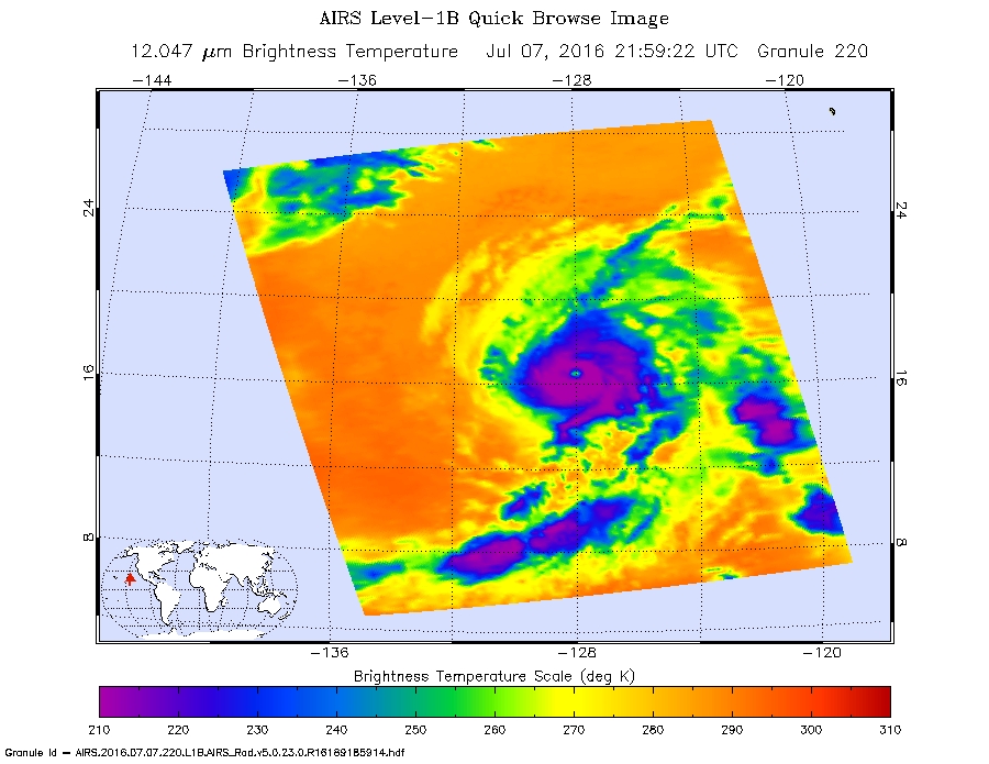
A pinhole or small eye in Blas was seen on infrared imagery taken on July 7 at 21:40 UTC (5:21 p.m. EDT) from the Atmospheric Infrared Sounder or AIRS instrument that flies aboard NASA’s Aqua satellite. The AIRS data showed powerful thunderstorms with cloud top temperatures as cold as minus 63 Fahrenheit (minus 53 Celsius) circling the small eye.
At 5 a.m. EDT (0900 UTC) on Friday, July 8, 2016 the center of Hurricane Blas was located near latitude 17.4 north and longitude 129.4 west. That’s about 1,320 miles (2,120 km) west-southwest of the southern tip of Baja California, Mexico. Blas was moving toward the west-northwest near 10 mph (17 kph). The National Hurricane Center expects a turn toward the northwest later in the day, and this motion is expected to continue through Saturday. A turn back toward the west-northwest is forecast Saturday night.
The estimated minimum central pressure is 972 millibars. Maximum sustained winds have decreased to near 105 mph (165 kph).
Rapid weakening is forecast during the next 48 hours, and Blas is expected to weaken to a tropical storm tonight. NHC expects Blas to become a post-tropical cyclone Sunday night or Monday, July 11. For updated forecasts visit the NHC website: www.nhc.noaa.gov
Rob Gutro
NASA’s Goddard Space Flight Center
July 07, 2016 – NASA Peers into Major Hurricane Blas
As NASA satellites gather data on the first major hurricane of the Eastern Pacific Ocean hurricane season, Blas continues to hold onto its Category 3 status on the Saffir Simpson Wind Scale.

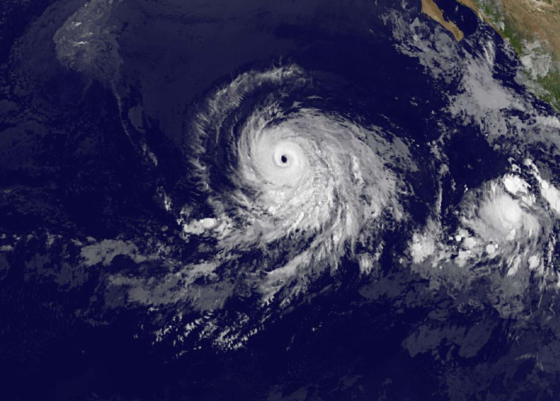
On July 6 at 2155 UTC (5:55 p.m. EDT) NASA-NOAA-DOD’s Suomi NPP satellite captured a visible light image of Hurricane Blas in the eastern Pacific Ocean. The image showed that Blas maintained a large eye with bands of powerful thunderstorms wrapping into the low-level center of circulation from the east.
On July 6 at 2122 UTC (5:22 p.m. EDT), the AIRS or Atmospheric Infrared Sounder instrument aboard NASA’s Aqua satellite captured an infrared view of Blas’ cloud top temperatures, revealing powerful storms around the eye. By July 7, the National Hurricane Center (NHC) reported that the eye had become a little less distinct in the morning, and the surrounding ring of deep convection has warmed over the northwestern portion of the circulation. When cloud top temperatures warm that means they are not extending as high in the troposphere and indicate that the uplift of air is weakening
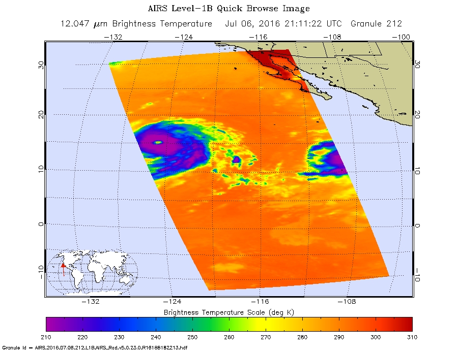
At 11 a.m. EDT (1500 UTC) on July 7, the center of Hurricane Blas was located near latitude 16.2 North, longitude 127.1 West. That’s about 1,210 miles (1,945 km) west-southwest of the southern tip of Baja California, Mexico. Blas was moving toward the west-northwest near 10 mph (17 kph), and the NHC said this motion is expected to continue through today. A turn toward the northwest is forecast on Friday.
Maximum sustained winds have decreased to near 120 mph (195 kph). NHC forecasts a weakening trend over the next two days and Blas is expected to weaken to a tropical storm by Friday night. For updated forecasts, visit the NHC website: www.nhc.noaa.gov.
Rob Gutro
NASA’s Goddard Space Flight Center
July 06, 2016 – NASA Gets an Eyeful of Hurricane Blas
Satellites eyeing powerful Hurricane Blas in the Eastern Pacific Ocean revealed a large eye as the powerful storm continued to move over open waters.
On July 4 at 20:50 UTC (4:50 p.m. EDT) the Visible Infrared Imaging Radiometer Suite (VIIRS) instrument aboard NASA-NOAA-DOD’s Suomi NPP satellite captured a visible light image of Hurricane Blas that showed a developing, and cloud-filled eye.

A visible image of Blas from NOAA’s GOES-West satellite taken on July 7 at 1200 UTC (8 a.m. EDT) revealed the eye opened wide. GOES-West saw a large 25 to 30 nautical mile (28.7 to 34.5 mile/46.3 to 55.5 wide eye surrounded by a symmetric ring of thunderstorms. The imagery also showed little outer banding (of thunderstorms).NOAA manages the GOES satellites and the NASA/NOAA GOES Project at NASA’s Goddard Space Flight Center in Greenbelt, Maryland uses data from them to create images and animations.
Infrared satellite data from July 6 revealed that Blas is currently in over sea surface temperatures of 27 to 28 degrees Celsius (80.6 to 82.4 degrees Fahrenheit). A tropical cyclone needs sea surface temperatures of at least 26.6 degrees Celsius (80 degrees Fahrenheit) to maintain intensity. Warmer temperatures assist in strengthening while colder temperatures help weaken a tropical system.
On Wednesday, July 6, 2016 at 11 a.m. EDT (1500 UTC), the center of Hurricane Blas was located near latitude 15.0 degrees north and longitude 123.6 degrees west. That’s about 1,045 miles (1,685 km) west-southwest of the southern tip of Baja California, Mexico. Blas was located far from land so there were no coastal watches or warnings in effect. Blas was moving toward the west-northwest near 12 mph (19 kph), and this general motion is expected to continue over the next couple of days.
Maximum sustained winds are near 125 mph (205 kph) making Blas a category 3 hurricane on the Saffir-Simpson Hurricane Wind Scale. The National Hurricane Center (NHC) said that slow weakening is forecast tonight and Thursday, followed by a faster rate of weakening by Friday, July 8. The estimated minimum central pressure is 956 millibars.
The NHC noted after the next day or day and a half “Blas will be moving over sea surface temperatures below 26 Celsius (78.8 Fahrenheit) which should cause a faster rate of weakening, and the cyclone is forecast to become post-tropical in about 4 days.”
Rob Gutro
NASA’s Goddard Space Flight Center
July 05, 2016 – NASA’s Analyzes First Hurricane of the Eastern Pacific Season
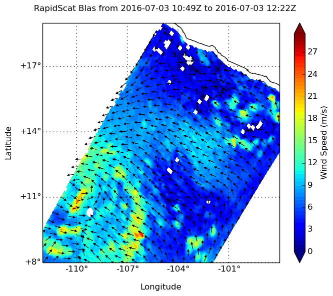
The second named tropical cyclone of the Eastern Pacific Ocean hurricane season has become a hurricane named Blas. NASA analyzed Blas in infrared light on July 5 and saw powerful thunderstorms with very cold cloud top temperatures after it reached hurricane status. Earlier, NASA’s RapidScat instrument analyzed surface winds as the storm was strengthening from a depression to a tropical storm.
The tropical depression that grew to become Tropical Storm Blas formed at 11 p.m. (0300 UTC) on Saturday, July 2. At that time the center of Tropical Depression Three-E was near latitude 11.1 north and longitude 108.3 west. By 5 a.m. EDT on July 3 the depression strengthened into a tropical storm.
On July 3, the RapidScat instrument that flies aboard the International Space Station saw surface winds east of Blas’ center near 21 meters per second (46.9 mph/75.6 kph). RapidScat is an important tool for meteorologists, because maximum sustained winds are not always equally distributed in a storm. RapidScat shows forecasters the location of the strongest winds in different quadrants of a storm, indicating locations facing greatest impacts.
By July 5, Blas had become the first hurricane of the Eastern Pacific hurricane season. At 5 a.m. EDT (0900 UTC) Maximum sustained winds have increased to near 100 mph (155 kph) with higher gusts.
The center of Hurricane Blas was located near latitude 14.2 North, longitude 118.1 West. That’s about 805 miles (1,295 km) southwest of the southern tip of Baja California. Blas is far from land, so there are no coastal watches or warnings in effect.
Blas was moving toward the west-northwest near 14 mph (22 kph), and a motion toward the west-northwest or west is expected for the next couple of days. The estimated minimum central pressure is 978 millibars.
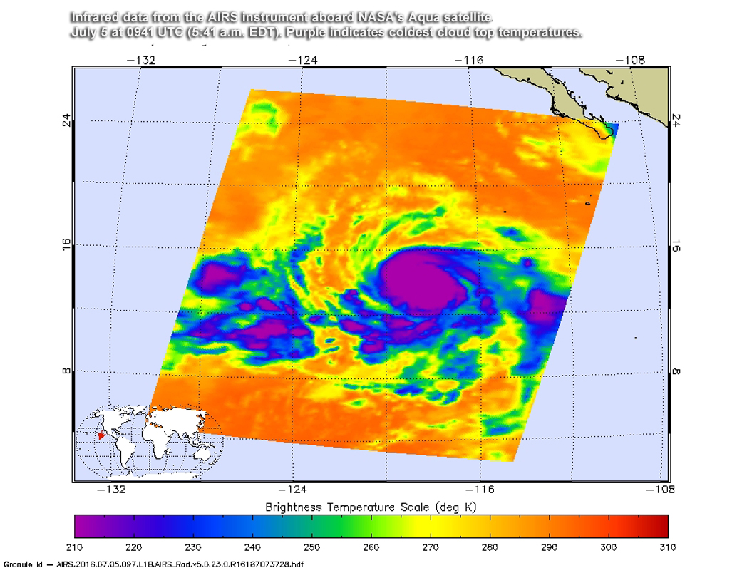
On July 5 at 0941 UTC (5:41 a.m. EDT) infrared data from the Atmospheric Infrared Sounder aboard NASA’s Aqua satellite detected strong thunderstorms completely surrounding the center with temperatures colder than minus 75 degrees Celsius (minus 103 Fahrenheit). That indicates very powerful thunderstorms with cloud tops high into the troposphere. Infrared data also suggests a ragged eye has developed.
Visible satellite data shows that the overall convective cloud pattern has also become more symmetrical.
The National Hurricane Center (NHC) said that additional strengthening is expected, and Blas is forecast to become a major hurricane later today, July 5. NHC noted that in two days, Blas will be moving over cooler waters that will put the storm on a weakening trend. For updates, visit: www.nhc.noaa.gov.