


Earth Planetary Instrumentation and Calibration (EPIC) Lab
The Earth Planetary Instrumentation and Calibration (EPIC) Lab at NASA’s Ames Research Center supports a variety of airborne research activities for the NASA Earth Science Division. It conducts engineering development of remote sensing instrumentation and real-time payload communications systems, and supports their operational use on science field campaigns. The EPIC Lab maintains a suite of facility instruments that are made available for use by NASA-approved research projects, with all resulting data being made available free of charge through public archives. These data are typically used for fundamental earth science process studies, satellite calibration and validation, development of retrieval algorithms, and disaster response.
Location
Ames Research Center
instruments
23
POC
Matthew Fladeland
April 21, 2026
Mapping Minerals
GEMx MASTER Image of CO
This composite image taken by MASTER uses VIS-TIR (Visible to Thermal Infrared) bands to evaluate the mineral composition of the ground beneath: each color in the image corresponds to a different material with unique reflective, emissive, and thermal properties. This image was taken over Colorado on April 21, 2026 as part of the NASA/USGS Geological Earth Mapping Experiment (GEMx). Credits: NASA/EPIC Lab
Learn More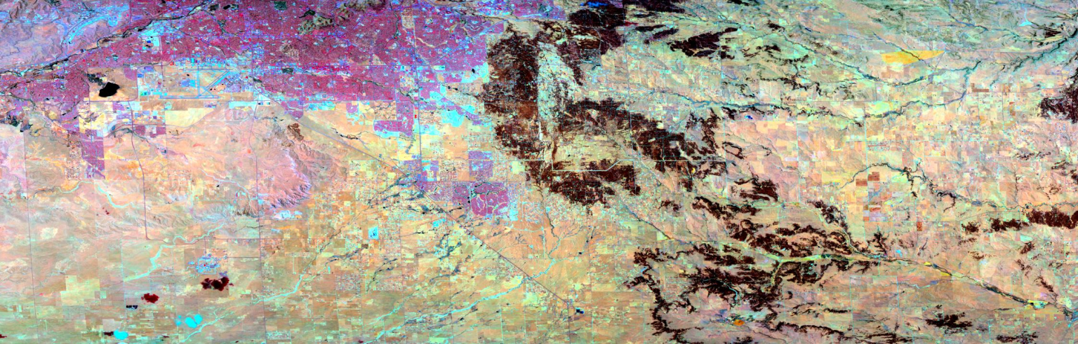
Featured Instruments
MASTER
The MODIS/ASTER Airborne Simulator (MASTER) is a modified Daedalus Wildfire scanning spectrometer which flies on a variety of multiple altitude research aircraft and provides spectral information similar to that which is provided by the Advanced Spaceborne Thermal Emission and Reflection Radiometer (ASTER) and the Moderate Resolution Imaging Spectroradiometer (MODIS) and, which is aboard two of NASA Earth Observing System Satellites, TERRA & AQUA.

PICARD
The Pushbroom Imager for Cloud and Aerosol Research and Development (PICARD) is a VNIR-SWIR airborne imaging spectrometer that primarily acquires imagery from the NASA ER-2 high altitude research aircraft. Operating over a wavelength range of 400-2500nm, the dual Offner spectrometers are mounted to a single four-mirror anastigmat telescope, designed to produce a distortion-free 50-degree field of view over cloud scenes. This wide field of view from high altitude provides a synoptic view of regional-scale atmospheric phenomena, and enables easier cross-comparisons with satellite imagery (e.g. MODIS, VIIRS, etc.)

MMS
The Meteorological Measurement System (MMS) is a state-of-the-art instrument for measuring accurate, high resolution in situ airborne state parameters (pressure, temperature, turbulence index, and the 3-dimensional wind vector). These key measurements enable our understanding of atmospheric dynamics, chemistry and microphysical processes.
All Instruments
Airborne Instruments
- eMAS
- MASTER
- PICARD
- TBIRD
- TMMS V2E
- Mjolnir
- C-AIR
- 4STAR
- 4STARB
- CAR
- MMS
- COMA
- SSFR
Field Instruments
- SeaSTAR
- ASD Field Spec4-NG
- SVC GER1500
- SVC HR-512i
- Kipp & Zonen Pyranometer
Network Instruments
- Ground-based Fourier Transform Spectrometer
- Cimel CE319: Multispectral UV/VIS/SWIR Photometer
- SciGlob Pandor: UV/Visible Hyperspectral Sun Photometer
- 2B Tech FEM Ozone Monitors
- INSTEP Low-Cost Sensors
By Air and by Sea: Validating NASA’s PACE Ocean Color Instrument
In autumn 2024, California’s Monterey Bay experienced an outsized phytoplankton bloom that attracted fish, dolphins, whales, seabirds, and – for…
Read the Story
Other Capabilities
Airborne Sensor Network Development
The Sensor Network is a key enabling technology for airborne science, extending real-time sensor webs to the core NASA science aircraft. It is intended to leverage simultaneous but independent supporting measurements, and to maximize science return from complex and expensive multi-aircraft science campaigns. When coupled with the web-based Mission Tools Suite, it enables interactive mission re-planning and flexible experiment design; and allows investigators to take full advantage of new sensor technologies (e.g. “smart” and/or reconfigurable sensors.)
View next-generation aircraft hardware
Payload Integration Engineering
Cross-center airborne instrument integration support with mechanical, electrical, and software engineering services. We also provide services in Flight Planning, Mission Coordination, Investigator Liaison, Post-Flight Data Evaluation, and Data Processing.
Optical and Infrared Calibration Laboratory
The Optical and Infrared Calibration Lab is responsible for the characterization of Earth-Viewing Sensor Systems in support of EOS Investigations, operating under the auspices of the EOS Calibration Scientist. Specially designed for airborne instruments, it conducts spectral and radiometric characterizations in the visible and infrared region, with a range of 350 nanometers to 14 microns.