


![Request for Information – Potential [Placeholder for Prize]](https://assets.science.nasa.gov/dynamicimage/assets/science/psd/solar/2023/09/s/solarsystem_0.jpg?w=1024)


Programs at Ames
NASA’s Earth Science Division is organized around four programmatic areas: flight, research, applied sciences, and technology. Together these areas include programs and projects that are responsible for: conducting and sponsoring research to advance scientific understanding of Earth as a system, collecting and disseminating new observations, developing new technologies and computational models, and building the capacity to develop innovative applications of Earth science observations and research results.
Current Programs
Sub-Mesoscale Ocean Dynamics Experiment (S-MODE)
Mission Overview
A major difficulty in simulating Earth’s climate system is that there are interactions across scales, so that the large time and space scales can be sensitive to processes on small scales. As the computational resolution of global ocean models has improved, scientists have begun to suspect that kilometer-scale eddies and fronts, called “submesoscale” variability, have a net effect on ocean-atmosphere heat exchange that is larger than the heating from the greenhouse effect (Su et al. 2018). State-of-the-art computer models agree in predicting that these eddies have important long-term effects on the upper-ocean, but their predictions are sensitive to relatively small details in model physics and implementation. The resolution and detail of these simulations has surpassed our ability to ‘ground truth’ them with spaceborne or in situ sensors. There is thus a pressing need for a comprehensive benchmark data set on these submesoscale motions to address this important source of uncertainty in simulating the global ocean.
This mission will test the hypothesis that submesoscale ocean dynamics make important contributions to vertical exchange of climate and biological variables in the upper ocean. This will require coordinated application of newly-developed in situ and remote sensing techniques, and it will provide an unprecedented view of the physics of submesoscale eddies and fronts and their effects on vertical transport in the upper ocean. The Sub-Mesoscale Ocean Dynamics Experiment (S-MODE) will use measurements from a novel combination of platforms and instruments, along with data analysis and modeling, to test the hypothesis.

DEVELOP
DEVELOP, part of NASA’s Applied Sciences Program, addresses environmental and public policy issues through interdisciplinary research projects that apply the lens of NASA Earth observations to community concerns around the globe. Bridging the gap between NASA Earth Science and society, DEVELOP builds capacity in both participants and partner organizations to better prepare them to address the challenges that face our society and future generations. With the competitive nature and growing societal role of science and technology in today’s global workplace, DEVELOP is fostering an adept corps of tomorrow’s scientists and leaders.
Arctic Boreal Vulnerability Experiment (ABoVE)
ABoVE is a NASA Terrestrial Ecology Program field campaign being conducted in Alaska and Western Canada. ABoVE’s science objectives are broadly focused on (1) gaining a better understanding of the vulnerability and resilience of Arctic and boreal ecosystems to environmental change in western North America, and (2) providing the scientific basis for informed decision-making to guide societal responses at local to international levels. Research for ABoVE links field-based studies with geospatial data products derived from airborne and satellite sensors, providing a foundation for improving predictive capabilities needed to understand ecosystem responses and societal implications of climate change. Scientists in Code SGE are modeling ecosystem carbon fluxes of CO2 and methane using NASA’s MODIS and Landsat imagery across the entire ABoVE study domain of Alaska and Canada. Christopher Potter (SGE) is a member of the JPL Science Team (C. Miller, PI) for “Quantifying CO2 and CH4 Fluxes from Vulnerable Arctic-Boreal Ecosystems Across Spatial and Temporal Scales”.

Ecological Forecasting
NASA Ames is developing advanced computer technologies for converting massive streams of satellite remote sensing data into ecocasts that are easy to read and use.
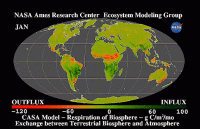
NASA-CASA Project
The NASA-CASA (Carnegie-Ames-Stanford Approach) project has been providing carbon dioxide (CO2) sequestration data sets to users globally for the past 30 years. The CASA Biosphere model simulates seasonal patterns in plant carbon fixation, biomass and nutrient allocation, soil nitrogen mineralization, and microbial CO2 emissions. CASA used NASA satellite imagery (e.g., Landsat) to estimate the yearly capture of CO2 from the atmosphere and the delivery of plant biomass to herbivores, decomposers, and to human populations.
Metrological Measurement Systems (MMS)
The Meteorological Measurement System (MMS) is a PI-led airborne instrument that provides calibrated, science quality, in situ state measurements of static pressure, static temperature, and three-dimension wind. Accurate measurements of these quantities require judicious choices of sensor lacations, repeated laboratory & flight calibrations, proper corrections for compressibility, adiabatic heating and flow distortion.
Sunphotometer Satellite Group
The Ames Sunphotometer/Satellite team, in collaboration with Battelle, Pacific Northwest Division, has developped an advanced instruments called Spectrometers for Sky-Scanning, Sun-Tracking Atmospheric Research (4STAR). They are a research group at NASA Ames Research Center specializing in measurements and analysis of atmospheric composition. We focus on aerosol radiative properties, trace gas retrievals, and cloud properties. We utilize airborne sunphotometers and various satellite instruments.
Past Programs and Missions:
Student Airborne Science Activation (SaSa) Internship
The Student Airborne Science Activation (SaSa) internship selected highly motivated early-career undergraduates at eligible universities to participate in an eight-week summer research experience covering different topics such as basic remote sensing principles, basic atmospheric thermodynamics, atmospheric stability, and data analysis.
Alpha Jet Atmospheric eXperiment (AJAX)
In 2007, a Space Act Agreement between NASA Ames Research Center and H211, LLC began a relationship that ultimately led to the formation of the Alpha Jet Atmospheric eXperiment (AJAX). Science measurement flights began in 2011 and AJAX performed regular missions to measure ozone (O3), formaldehyde (HCHO), carbon dioxide (CO2), methane (CH4) and meteorological data over California and Nevada.
Investigation of Microphysics and Precipitation for Atlantic Coast-Threatening Snowstorms (IMPACTS)
The Investigation of Microphysics and Precipitation for Atlantic Coast-Threatening Snowstorms (IMPACTS) flew a complementary suite of remote sensing and in-situ instruments for three 6-week deployments on the ER-2 and P-3 aircraft. IMPACTS addressed three specific objectives, providing observations critical to understanding the mechanisms of snowband formation, organization, and evolution. IMPACTS also examined how the microphysical characteristics and likely growth mechanisms of snow particles vary across snowbands. IMPACTS improved snowfall remote sensing interpretation and modeling to significantly advance predictive capabilities.
Convective Processes Experiment – Aerosols & Winds (CPEX-AW)
The Convective Processes Experiment – Aerosols & Winds (CPEX-AW) campaign is a joint effort between the US National Aeronautics and Space Administration (NASA) and the European Space Agency (ESA) with the primary goal of conducting a post-launch calibration and validation activities of the Atmospheric Dynamics Mission-Aeolus (ADM-AEOLUS) Earth observation wind Lidar satellite in St. Croix. CPEX-AW is a follow-on to the Convective Processes Experiment (CPEX) field campaign which took place in the summer of 2017 (https://cpex.jpl.nasa.gov/). In addition to joint calibration/validation of ADM-AEOLUS, CPEX-AW will study the dynamics and microphysics related to the Saharan Air Layer, African Easterly Waves and Jets, Tropical Easterly Jet, and deep convection in the InterTropical Convergence Zone (ITCZ).
Asian Summer Monsoon Chemical & CLimate Impact Project (ACCLIP)
The National Aeronautics and Space Administration (NASA) and the National Center for Atmospheric Research (NCAR) will conduct a two-month campaign in Summer 2022: the Asian Summer Monsoon Chemical & CLimate Impact Project (ACCLIP). This campaign will deploy from Osan Air Base in South Korea. However, as part of the preparations for the late Summer 2022 deployment, a series of test flights will take place at Ellington Field (Johnson Space Center, Houston, Texas) in late Summer 2021.
In 2022, two aircraft (the NASA WB-57 and the NCAR G-V), outfitted with state-of-the-art sensors, and approximately 80 scientists from the US and other international research organizations will participate in ACCLIP.
The Asian Summer Monsoon (ASM) is the largest meteorological pattern in the Northern Hemisphere (NH) summer season. Persistent convection and the large anticyclonic flow pattern in the upper troposphere and lower stratosphere (UTLS) associated with ASM leads to a significant enhancement in the UTLS of trace species from pollution and biomass burning origins. The monsoon convection occurs over South, Southeast, and East Asia, a region of uniquely complex and rapidly changing emissions tied to both its high population density and significant economic growth. The coupling of the most polluted boundary layer on Earth to the largest dynamical system in the summer season through the deep monsoon convection has the potential to create significant chemical and climate impacts. An accurate representation of the ASM transport, chemical and microphysical processes in chemistry-climate models is much needed for characterizing ASM chemistry-climate interactions and for predicting its future impact in a changing climate.
Dynamics and Chemistry of the Summer Stratosphere (DCOTSS)
There is a compelling need for intensive study of convective impacts on the summer stratosphere over North America. Each summer the North American Monsoon Anticyclone (NAMA) dominates the circulation of the North-Western Hemisphere and acts to partially confine and isolate air from the surrounding atmosphere. Strong convective storms in the NAMA regularly penetrate deep into the lower stratosphere (LS), with some ascending above 20 km (~450 K potential temperature). The uniqueness of the NAMA region is most easily seen in satellite measurements of water vapor, which show a large enhancement in the LS over North America not seen either in magnitude or at such high latitudes elsewhere around the globe. But the coupling of tropopause-penetrating convection with large-scale monsoonal motion is poorly understood, as is the impact of convection on the chemical composition of the LS, both in monsoon regions and in the global stratosphere, which receives inputs of moist and polluted monsoon air from the NAMA. The Dynamics and Chemistry of the Summer Stratosphere (DCOTSS) project directly addresses this knowledge gap.
Laboratory for Advanced Sensing
The NASA Ames Laboratory for Advanced Sensing (NASA LAS), led by Dr. Ved Chirayath, focused on science-driven sensing and technology development for next-generation instruments, to better understand the world and benefit humanity. NASA LAS operated in NASA Ames’ Earth Science Division with a primary focus on developing novel instrumentation and information systems to advance NASA’s Earth Science objectives.
For more information, including additional capabilities, click here.
V
The Cloud, Aerosol and Monsoon Processes Philippines Experiment (CAMP2Ex)
The Cloud, Aerosol and Monsoon Processes Philippines Experiment (CAMP2Ex) is a response to the need to deconvolute the fields of tropical meteorology and aerosol science at the meso-b to cloud level. The operations will base at Clark International Airport (Philippines). The campaign is scheduled for mid-August to October 2019.
Aerosol and cloud microphysics: Examine how aerosol particle concentration and composition affect the optical and microphysical properties of shallow cumulous and congest clouds; and how, ultimately, these effects relate to the transition from shallower to deeper convection.
Cloud and Aerosol Radiation: Study how spatially inhomogeneous and changing aerosol and cloud fields impact three dimensional heating rates and fluxes, and determine the extent to which three dimensional effects may feedback into the evolution of the aerosol, cloud, and precipitation fields.
Aerosol and cloud meteorology: Determine the meteorological features that are the most influential in regulating the distribution of aerosol particles throughout the regional atmosphere and, ultimately, aerosol lifecycle, and ascertain the extent to which aerosol-cloud interactions studies are confounded and/or modulated by co-varying meteorology.
The NASA P3 (N426NA) will be the platform. Nominally 3000 nm range, 8-10 hours endurance. (White Paper)
Fire Influence on Regional to Global Environments Experiment – Air Quality (FIREX-AQ)
Fire emissions in the US are approximately half from Northwestern wildfires and half from prescribed fires that burn mostly in the Southeast US (Figure 2). Wildfires burn slightly more fuel and therefore have overall larger emissions, but prescribed fires dominate the area burned and the number of fires. FIREX-AQ will investigate both wild and prescribed fires. Wildfires generally result in exposures with larger pollution concentrations over larger areas, and cause both local and regional air quality impacts. Their emissions are often transported thousands of miles and can impact large regions of the US at a time (Figure 3). Prescribed fires are usually smaller and less intense than most wildfires but occur more frequently and throughout the whole year. They are usually ignited during periods that minimize population expose and air quality impacts, but can cause regional backgrounds to increase, are generally in closer proximity to populations, and are responsible for a large fraction of the US PM2.5 emissions. To date agricultural fire outputs are still poorly represented in emission inventories. The overarching objective of FIREX-AQ is to provide measurements of trace gas and aerosol emissions for wildfires and prescribed fires in great detail, relate them to fuel and fire conditions at the point of emission, characterize the conditions relating to plume rise, follow plumes downwind to understand chemical transformation and air quality impacts, and assess the efficacy of satellite detections for estimating the emissions from sampled fires.
For more information please visit the ESRL website here.

Atmospheric Tomography Mission (ATom)
The Atmospheric Tomography Mission (ATom) will study the impact of human-produced air pollution on greenhouse gases and on chemically reactive gases in the atmosphere. Reductions of atmospheric concentrations of methane (CH4), tropospheric ozone (O3) and black carbon (BC) aerosols are effective measures to slow global warming and to improve air quality. Airborne instruments will look at how atmospheric chemistry is transformed by various air pollutants and at the impact on CH4 and O3. Mitigation of these short-lived climate forcers is a major component of current international policy discussions.
ATom deploys an extensive gas and aerosol payload on the NASA DC-8 aircraft for systematic, global-scale sampling of the atmosphere, profiling continuously from 0.2 to 12 km altitude. Flights will occur in each of 4 seasons over a 4-year period. They will originate from the Armstrong Flight Research Center in Palmdale, California, fly north to the western Arctic, south to the South Pacific, east to the Atlantic, north to Greenland, and return to California across central North America. ATom establishes a single, contiguous global-scale data set. This comprehensive data set will be used to improve the representation of chemically reactive gases and short-lived climate forcers in global models of atmospheric chemistry and climate. Profiles of the reactive gases will also provide critical information for validation of satellite data, particularly in remote areas where in situ data is lacking.
ATom’s tomographic, large-scale sampling combined with parcel-by-parcel quantification of photochemical tendencies provides a strong response to the 2011 NASA Strategic Plan to Advance Earth System Science: meeting the challenges of climate and environmental change on a global scale.
ATom improves predictions of human-caused and natural changes in climate forcing and air quality over the entire globe, engaging the science Focus Areas: Atmospheric Composition (primary); Carbon Cycle and Ecosystems (role of CH4), and Climate Variability and Change (radiative forcing of CH4 and O3).
Operation IceBridge
IceBridge, a six-year NASA mission, is the largest airborne survey of Earth’s polar ice ever flown. It will yield an unprecedented three-dimensional view of Arctic and Antarctic ice sheets, ice shelves and sea ice. These flights will provide a yearly, multi-instrument look at the behavior of the rapidly changing features of the Greenland and Antarctic ice.
follow @NASA_ICE for mission tweets.
ORACLES (ObseRvations of Aerosols above CLouds and their intEractionS)
Southern Africa produces almost a third of the Earth’s biomass burning (BB) aerosol particles, yet the fate of these particles and their influence on regional and global climate is poorly understood. ORACLES (ObseRvations of Aerosols above CLouds and their intEractionS) is a five year investigation with three Intensive Observation Periods (IOP) designed to study key processes that determine the climate impacts of African BB aerosols. Particles lofted into the mid-troposphere are transported westward over the SE Atlantic, home to one of the three permanent subtropical Stratocumulus (Sc) cloud decks in the world. The stratocumulus “climate radiators” are critical to the regional and global climate system. They interact with dense layers of BB aerosols that initially overlay the cloud deck, but later subside and are mixed into the clouds. These interactions include adjustments to aerosol-induced solar heating and microphysical effects. As emphasized in the latest IPCC report, the global representation of these aerosol-cloud interaction processes in climate models is the largest uncertainty in estimates of future climate.
The ORACLES experiment provides multi-year airborne observations over the complete vertical column of the key parameters that drive aerosol-cloud interactions in the SE Atlantic, an area with some of the largest inter-model differences in aerosol forcing assessments on the planet.
Coastal and Ocean Airborne Science Testbed (COAST)
The Coastal and Ocean Airborne Science Testbed (COAST) Project is a NASA Earth-science flight project that will advance coastal ecosystems research by providing a unique airborne payload optimized for remote sensing in the optically complex coastal zone
The COAST instrument suite combines a customized imaging spectrometer, sunphotometer system, and new bio-optical radiometer instruments to obtain ocean/coastal/atmosphere data simultaneously. The imaging spectrometer is optimized in the blue region of the spectrum to emphasize remote sensing of marine and freshwater ecosystems. Simultaneous measurements for empirical characterization of the atmospheric column will be accomplished using the Ames Airborne Tracking Sunphotometer (AATS-14). The radiometer system, designed and built by Biospherical Instruments, Inc., collects high quality radiance data from the ocean surface. Dr. Liane Guild of NASA Ames Biospheric Science Branch is the principal investigator.
Credit: NASA/Jennifer Dungan
Airborne Tropical Tropopause Experiment (ATTREX)
Despite its low concentration, stratospheric water vapor has large impacts on the earth’s energy budget and climate. Recent studies suggest that even small changes in stratospheric humidity may have climate impacts that are significant compared to those of decadal increases in greenhouse gases. Future changes in stratospheric humidity and ozone concentration in response to changing climate are significant climate feedbacks.
While the tropospheric water vapor climate feedback is well represented in global models, predictions of future changes in stratospheric humidity are highly uncertain because of gaps in our understanding of physical processes occurring in the Tropical Tropopause Layer (TTL, ~13-18 km), the region of the atmosphere that controls the composition of the stratosphere. Uncertainties in the TTL chemical composition also limit our ability to predict future changes in stratospheric ozone.
Airborne Tropical TRopopause EXperiment (ATTREX) will perform a series of measurement campaigns using the long-range NASA Global Hawk (GH) unmanned aircraft system (UAS) to directly address these problems.
Hurricane and Severe Storm Sentinel (HS3)
The Hurricane and Severe Storm Sentinel (HS3) is a five-year mission specifically targeted to investigate the processes that underlie hurricane formation and intensity change in the Atlantic Ocean basin. HS3 is motivated by hypotheses related to the relative roles of the large-scale environment and storm-scale internal processes. HS3 addresses the controversial role of the Saharan Air Layer (SAL) in tropical storm formation and intensification as well as the role of deep convection in the inner-core region of storms. Addressing these science questions requires sustained measurements over several years due to the limited sampling opportunities in any given hurricane season. Past NASA hurricane field campaigns have all faced the same limitation: a relatively small sample (3-4) of storms forming during the campaigns under a variety of scenarios and undergoing widely varying evolutions. The small sample is not just a function of tropical storm activity in any given year, but also the distance of storms from the base of operations.
The NASA Global Hawk UASs are ideal platforms for investigations of hurricanes, capable of flight altitudes greater than 55,000 ft and flight durations of up to 30 h. HS3 will utilize two Global Hawks, one with an instrument suite geared toward measurement of the environment and the other with instruments suited to inner-core structure and processes. The environmental payload includes the scanning High-resolution Interferometer Sounder (HIS), dropsondes, theTWiLiTE Doppler wind lidar, and the Cloud Physics Lidar (CPL) while the over-storm payload includes the HIWRAP conically scanning Doppler radar, the HIRAD multi-frequency interferometric radiometer, and the HAMSR microwave sounder. Field measurements will take place for one month each during the hurricane seasons of 2012-2014.
CASIE
NASA established a new science field campaign in 2009 to study sea ice roughness and break-up in the Arctic and high northern latitudes. This mission, known as CASIE-09 (Characterization of Arctic Sea Ice Experiment 2009), was conducted under the auspices of the International Polar Year (IPY), a major international scientific research effort.