


![Request for Information – Potential [Placeholder for Prize]](https://assets.science.nasa.gov/dynamicimage/assets/science/psd/solar/2023/09/s/solarsystem_0.jpg?w=1024)


GNSS Use in Space
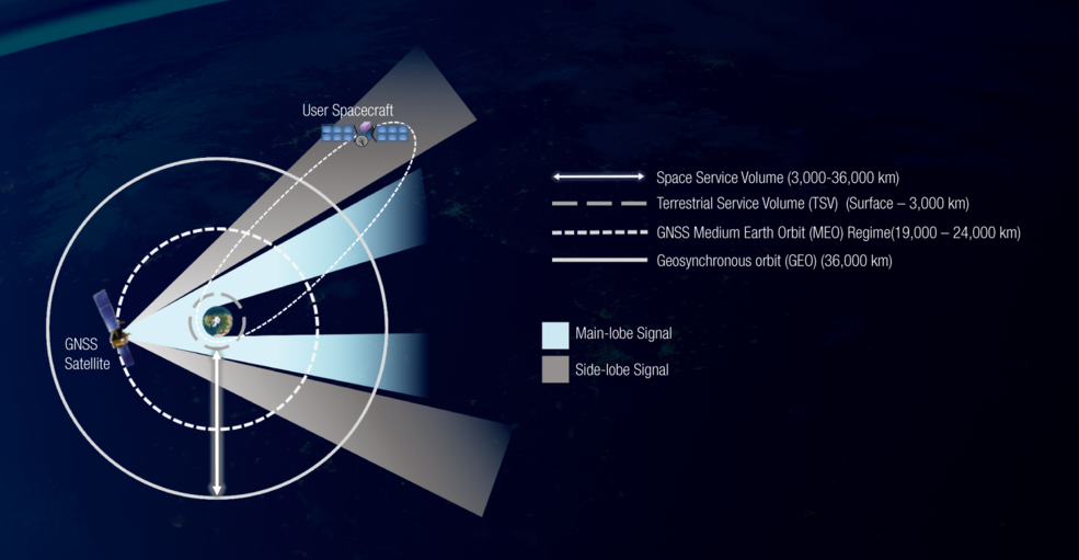
Global Navigation Satellite Systems (GNSS), including the U.S. Global Positioning System (GPS), were designed to provide positioning, navigation, and timing (PNT) services to users on land, sea, and in the air. Now, they are also being used in space, for applications including real-time spacecraft navigation, timing, and scientific observations. In Low Earth Orbit (LEO), where most space users reside, GNSS signal reception is similar to that on Earth’s surface. But, there is an increasing number of users in higher orbits as well, in what is known as the Space Service Volume (SSV).
The Space Service Volume
Use of GNSS at high altitudes (near or above the GNSS constellations themselves) utilize signals that travel past the limb of the Earth. This is more challenging because of lower received signal power levels , reduced line-of-sight visibility, and less optimal geometric diversity. This can be overcome by a combination of techniques, including:
- using specialized high-altitude recievers
- using multiple interoperable GNSS constellations together
- utilizing the full transmit signals, including the side-lobes
The combined PNT capabilities of the various GNSS constellations and regional navigation systems has been documented by the United Nations as the Interoperable GNSS Space Service Volume (SSV), which defines baseline signal performance in the region between LEO (3,000 km) and Geosynchronous Orbit (GEO) altitude (~36,000 km).
Applications
The Multi-GNSS SSV enables new and enhanced capabilities and better performance for GEO and other high-altitude missions, such as:
- Improved Earth weather and hazards monitoring
- Improved space weather observations, such as the interaction of solar wind and Earth’s magnetic field
- Precise position knowledge and control at GEO, which would allow for more communication and weather satellites in the crowded GEO belt
- Improved relative positioning between spacecraft, enabling formation flying
- Improved proximity operations, such as satellite servicing missions
- Improved space situational awareness
An International Effort
In 2018, the United Nations Office of Outer Space Affairs released “The Interoperable GNSS Space Service Volume,” (ST/SPACE/75) (See image on right) which defines the coordinate definition and baseline performance of the SSV internationally. It was developed and ratified by all six GNSS providers, including BeiDou (China), Galileo (European Union), GLONASS (Russia), GPS (United States), NavIC (India), and QZSS (Japan). The UN International Committee on GNSS (ICG) continues to develop and improve the SSV concept with participation by providers and user communities.
Benefits of GNSS in High Earth Orbits
There are numerous benefits to utilizing GNSS in the SSV over traditional navigation techniques, including:
- More precise, real-time knowledge of the orbit
- Increased resiliency due to multi-GNSS signal diversity
- Improved autonomy, thus reducing reliance on support infrastructure
- Rapid response to maneuvers, resulting in improved on-orbit agility
- Ability to use lower-cost components (esp. clocks) on-board the spacecraft
These have been demonstrated on-orbit by the NASA/NOAA GOES-R series in GEO, and by NASA’s Magnetospheric Multiscale (MMS) mission at nearly half the distance to the moon.
Forward to the Moon with GNSS
Many spacecraft, including science, exploration, and launch vehicle upper stages, operate beyond GEO altitude and as far as the Moon. The ability to use GPS signals halfway to the Moon was demonstrated by NASA’s MMS mission, and efforts are underway to fly a receiver all the way to lunar distance as well. NASA is working with international partners through the UN ICG to fully develop the SSV to support science and exploration missions beyond GEO and into cis-lunar space.