


Challenges
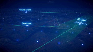
Current day air traffic management systems are segmented by domain, operator groups, and solution provider groups, which creates a challenge for those seeking a system wide solution. Future airspace operations will be increasingly more complex as new types of aircraft (such as on-demand air taxis and autonomous drone deliveries) intensify traffic density. This will require the aviation community to embrace a wider range of managing aircraft operations. Traditional systems were built in an era when rapid technologies were not available or commonplace. Changing the large and complex system-of-systems in the National Airspace System (NAS) is an overwhelmingly complex integration challenge, which often requires significant domain knowledge about operations and data.
Project Overview
The Digital Information Platform (DIP) team aims to tackle these challenges and address the stakeholder needs. The subproject is one of four contained within the Air Traffic Management – eXploration (ATM-X) project. The primary focus of DIP is to develop and demonstrate a digital service-oriented framework to enable increasingly safe and efficient operations for today and the future airspace system.
The subproject is actively partnering with flight operators, new entrants, service providers, data integrators, platform providers, and other aviation stakeholders who are committed to building and evaluating a community-supported system of digital services to enhance future aviation operations. Four operational evaluations missions are being conducted to validate concepts that will improve operational efficiency and predictability.
The DIP team is embracing advances in technology through cloud-based infrastructures and artificial intelligence/machine learning (AI/ML) to provide improved decision making tools to flight operators that are more collaborative and scalable in nature. more collaborative, integrated, and scalable way.
Concept Overview

DIP Research Areas
Cloud-based microservices infrastructure – The subproject plans to define an interoperability framework that will allow disparate software services to connect and exchange data relying on standards and protocols across various platforms. In addition, a cybersecurity management framework will be defined to assure the confidentiality, integrity, authenticity, and availability of NASA and partner data assets available on or through the platform.

Digital trajectory management – The DIP team is conducting a series of operational evaluations with its airline partners, the aviation industry and the Federal Aviation Administration to showcase digital trajectory management capabilities in real operational environments. Alternate route options are being evaluated, which reduce the pre- and post-departure delays at both the individual flight and fleetwide levels.

AI/ML use case exploration – The use of AI/ML aviation services offer robust and scalable solutions that can significantly reduce the deployment costs of decision support tools for flight operators and service providers compared to legacy physics-based systems. The subproject has developed and released open-source software for AI/ML solutions that can be readily adopted by the aviation industry and combined in various ways to meet their specific needs.