


Firefighters in Alberta have been fighting the Chuckegg Creek fire for five days now. The latest strategy is to take advantage of the direction the wind was blowing to conduct a burnout to eliminate fuel that allows the fire to continue to grow. The burnout impedes the fires ability to run or jump areas because the fuel it needs for further growth has been removed. To date 227,000 acres have already burned. The weather forecast for the coming weekend is predicting winds out of the northeast or north northeast which is favorable to firefighters efforts to continue conducting the burnout and to construct firelines to the east and northeast. On Sunday, however, warm temperatures will invade the area and the winds will switch direction to southwest or southeast which will cause issues for firefighters.

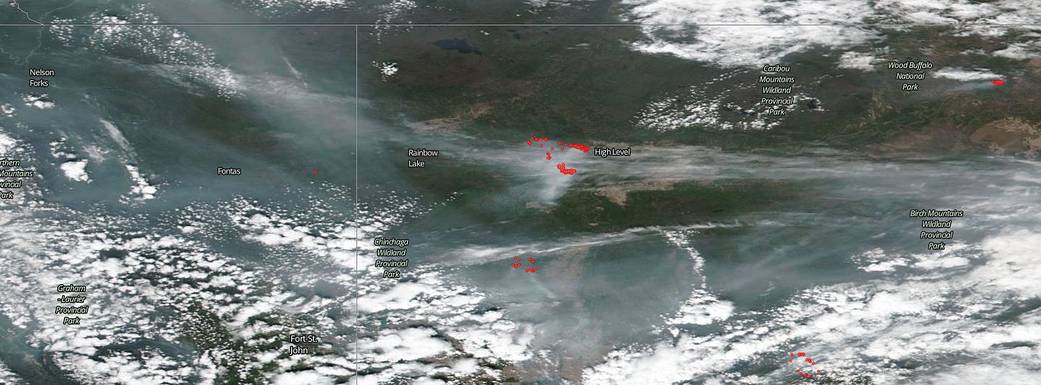
So too the aerosols seems to be growing more dense in the area as more and more smoke and particulates rise into the atmosphere. Yesterday, the image of the aerosols stretching from Alaska to the Atlantic was published. Today the mapping of aerosols just above Alberta’s Chuckegg Creek fire near the town of High Level shows medium to high level amounts of pollution, particulates in the form of smoke, dust, and ash. In the main image, smoke is visible across most of the landscape. Comparing the smoke in the first image to the aerosols in the second image it is interesting to note that the higher levels of smoke coincide with the areas of red on the aerosols image and the areas where the smoke is less dense coincide with the lighter yellow areas of the aerosols image as would be expected. The second image used data obtained on May 23, 2019 from both the Ozone Mapping and Profiler Suite (OMPS) sensor and the Visible and Infrared Imaging Sensor (VIIRS) onboard the Suomi NPP satellite.
NASA’s Earth Observing System Data and Information System (EOSDIS) Worldview application provides the capability to interactively browse over 700 global, full-resolution satellite imagery layers and then download the underlying data. Many of the available imagery layers are updated within three hours of observation, essentially showing the entire Earth as it looks “right now.” This Suomi NPP satellite image was collected on May 23, 2019. Actively burning fires, detected by thermal bands, are shown as red points. Image Courtesy: NASA Worldview, Earth Observing System Data and Information System (EOSDIS). Caption: Lynn Jenner with information from Wildfire Today on May 23.