


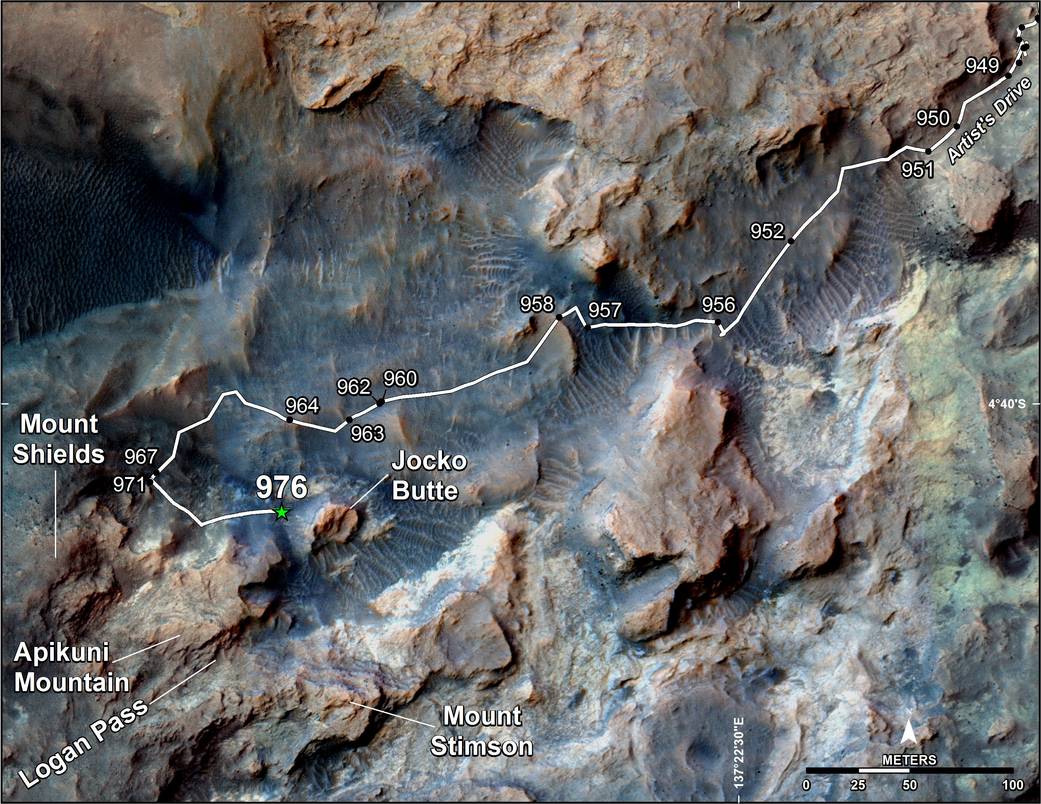
This map shows the route on lower Mount Sharp that NASA’s Curiosity followed in April and early May 2015, in the context of the surrounding terrain. Numbers along the route identify the sol, or Martian day, on which it completed the drive reaching that point, as counted since its 2012 landing.
The map covers an area about one-third of a mile (half a kilometer) across. North is up. The base image is from the High Resolution Science Experiment (HiRISE) camera on NASA’s Mars Reconnaissance Orbiter.
Curiosity departed the “Pahrump Hills” outcrop — mostly off the upper right corner of the map — through “Artist’s Drive” valley. The Sol 949 drive was completed on April 7, 2015. A HiRISE image actually showing Curiosity at that spot is at http://photojournal.jpl.nasa.gov/catalog/PIA19392. At that time, the rover’s next planned science destination was “Logan Pass,” an area where two geological units meet.
At the Sol 951 location, Curiosity’s Mast Camera (Mastcam) took component images for a sweeping panorama to the south and southwest, at http://photojournal.nasa.gov/catalog/PIA19397 and http://mars.nasa.gov/msl/multimedia/deepzoom/PIA19397 . At the Sol 956 location, the Mastcam took component images for a westward panorama, at http://photojournal.jpl.nasa.gov/catalog/PIA19398 and http://mars.nasa.gov/msl/multimedia/deepzoom/PIA19398 . From views such as these, Curiosity’s science team selected an additional site for close inspection, at the base of a rise called “Mount Shields.” The rover arrived there with the Sol 967 drive, completed on April 26, 2015.
After the observations and measurements made by Curiosity’s instruments at the base of Mount Shields, the rover resumed its approach to Logan Pass, on a route passing west of “Jocko Butte.” The Sol 976 drive was completed on May 5, 2015.
Wider-context maps are online at http://photojournal.jpl.nasa.gov/catalog/PIA19390 and http://photojournal.jpl.nasa.gov/catalog/PIA19067 . Updated location maps for Curiosity are posted frequently at http://mars.nasa.gov/msl/mission/whereistherovernow/ . More information about Curiosity is online at https://www.nasa.gov/msl and http://mars.jpl.nasa.gov/msl/.