


On February 9, 2023, an ozone-measuring instrument on the recently launched NOAA-21 satellite opened its doors and, over the course of a week, gathered data for its first global image. The Ozone Mapping and Profiler Suite (OMPS) consists of three sensors that monitor Earth’s ozone layer and track its recovery.
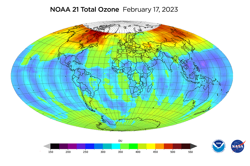
The map above, created using OMPS data, shows total ozone concentrations in the atmosphere around the globe. Higher ozone levels are concentrated in far northern latitudes, which is typical for this time of year.
OMPS was originally designed to measure ozone high in the atmosphere; this ozone layer protects humans and other life on Earth from the harmful effects of ultraviolet radiation. This is not to be confused with ground-level ozone, a harmful air pollutant and the main ingredient in smog.
“We want to be able to measure ozone changes to one percent or better over a 10-year timescale,” said Glen Jaross, NASA’s OMPS instrument scientist for the Joint Polar Satellite System.
In the decade since the first OMPS was launched on the Suomi-NPP satellite, the instrument’s capabilities have expanded to include observations of aerosols, such as smoke from wildfires and sulfur dioxide and ash from volcanoes. For example, on February 17, 2023, OMPS detected volcanic aerosols still lingering from the massive Hunga Tonga volcanic eruption in the South Pacific, which spewed water vapor and sulfur dioxide into the stratosphere more than a year ago.
NASA began measuring ozone from space in 1979, not long before scientists discovered that harmful chemicals called chlorofluorocarbons, or CFCs, could cause dangerous depletion of atmospheric ozone. By the mid-1980s, scientists discovered a “hole” in the ozone layer of the stratosphere over Antarctica. An international effort to ban these gases began with the Montreal Protocol in 1987 and has resulted in stabilization of ozone levels over the past three decades. Recent measurements indicate ozone levels are beginning to recover.
OMPS detects what’s known as “backscattered” light from the atmosphere — sunlight that reflects off particles and gases in the atmosphere or off of Earth’s surface.
Think of it like a laser shining on a disco ball, Jaross said. “The Sun is like a laser, and all the sparkles are light reflected off the Earth. And OMPS is sitting out there, picking up all that light.”
The area at the top of the map is gray because the North Pole is in a period of darkness known as “polar night,” when the Sun doesn’t rise at all. With no backscattered sunlight to detect, OMPS is unable to take measurements there during this time.
OMPS looks at that backscattered light in two ways. The Nadir Mapper and Nadir Profiler point directly down at Earth to map total ozone over the globe and to collect precise measurements at different altitudes. The Limb Profiler examines the atmosphere at an angle.
This latest version of OMPS on NOAA-21 has some improvements. The spatial resolution on the mapping instrument has been improved from about 30 by 30 miles on the Suomi-NPP satellite to about 6 by 6 miles on NOAA-21. The latest instrument can also measure nitrogen dioxide, a precursor to ground-level ozone.
“Quantifying these atmospheric gases is important for a variety of reasons, including monitoring the ozone layer and its interactions with climate change, tracking volcanic sulfur dioxide and ash for air traffic safety, and identifying pollution sources and levels for general air quality health assessments,” said NOAA’s JPSS Program Scientist Satya Kalluri.
Together, NOAA and NASA oversee the development, launch, testing, and operation of all the satellites in the Joint Polar Satellite System program. NOAA funds and manages the program, operations, and data products. NASA develops and builds the instruments, spacecraft, and ground system, and launches the satellites, which NOAA operates.
Image caption: Total ozone measured by the OMPS Nadir Mapper on February 17, 2023. Credits: NASA/NOAA/JPSS