


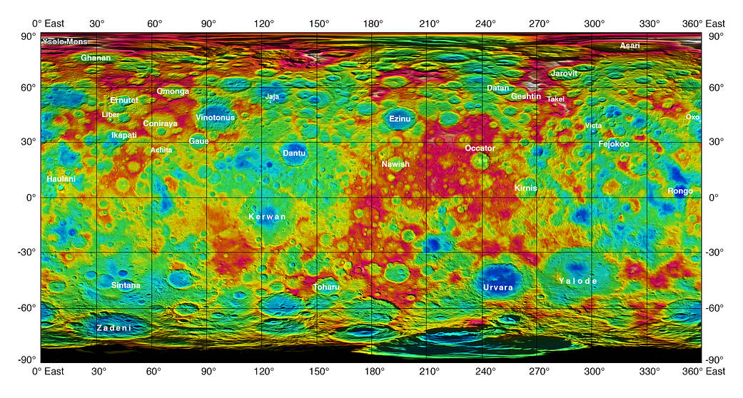
This color-coded map from NASA’s Dawn mission shows the highs and lows of topography on the surface of dwarf planet Ceres. It is labeled with names of features approved by the International Astronomical Union.
The color scale extends about 5 miles (7.5 kilometers) below the reference surface in indigo to 5 miles (7.5 kilometers) above the reference surface in white.
The brightest spots on Ceres, located in Occator crater, retain their bright appearance in this map, although they are color-coded in the same green elevation of the crater floor in which they sit. The one named mountain on Ceres is called Ysolo Mons, and lies high in the northern hemisphere at upper left.
The topographic map was constructed from analyzing images from Dawn’s framing camera taken from varying sun and viewing angles. The map was combined with an image mosaic of Ceres and rendered as a simple cylindrical projection. Not pictured is Kait crater, which lies on longitude 0.
Dawn’s mission is managed by JPL for NASA’s Science Mission Directorate in Washington. Dawn is a project of the directorate’s Discovery Program, managed by NASA’s Marshall Space Flight Center in Huntsville, Alabama. UCLA is responsible for overall Dawn mission science. Orbital ATK, Inc., in Dulles, Virginia, designed and built the spacecraft. The German Aerospace Center, the Max Planck Institute for Solar System Research, the Italian Space Agency and the Italian National Astrophysical Institute are international partners on the mission team. For a complete list of acknowledgments, see http://dawn.jpl.nasa.gov/mission.
For more information about the Dawn mission, visit http://dawn.jpl.nasa.gov.
Credit: NASA/JPL-Caltech/UCLA/MPS/DLR/IDA