


NASA-NOAA’s Suomi NPP Sees a Lopsided Tropical Storm Henri
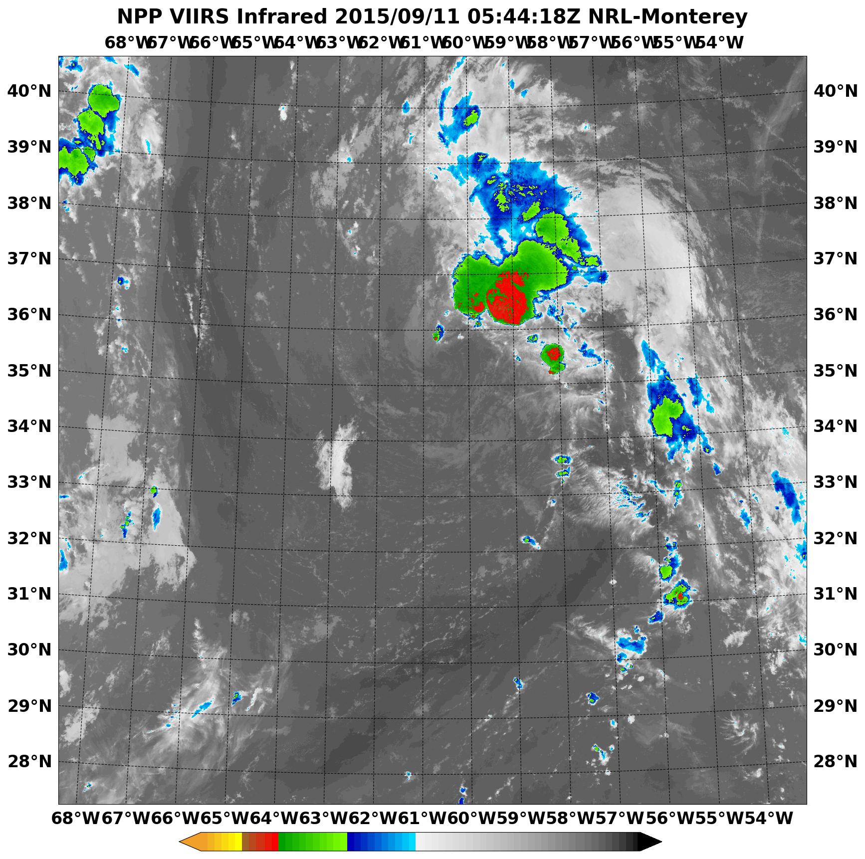
NASA-NOAA’s Suomi NPP satellite passed over Tropical Storm Henri on September 11 and saw that almost all of the clouds and showers associated with the storm were on the northeastern side of the storm.
At 0544 UTC (1:44 a.m. EDT) Infrared data from the Visible Infrared Imaging Radiometer Suite or VIIRS instrument that flies aboard Suomi NPP showed cloud top temperatures in the northeastern quadrant of Henri were as cold as -63F/-53C, indicating strong storms reaching high into the troposphere. Clouds around the rest of the tropical storm were warmer (and much lower in the atmosphere) and devoid of rainfall.
Southeasterly wind shear is responsible for pushing the clouds and showers to the northeast of Henri’s center. In addition, there’s dry air around the system which is inhibiting the development of thunderstorms in the other areas of the storm.
National Hurricane Center forecaster Kimberlain noted on September 11 at 5 a.m. EDT, “While nearly all of the cyclone’s deep convection is still located well to the northeast of the center, a relatively new convective burst over this area has grown in coverage and cloud tops have cooled.”
At 5 a.m. EDT (0900 UTC), the center of Tropical Storm Henri was located near latitude 36.2 North, longitude 60.3 West. That’s about 370 miles (600 km) northeast of Bermuda and about 815 miles (1,310 km) south-southwest of Cape Race Newfoundland, Canada. Maximum sustained winds were near 40 mph (65 kph) and little change in strength is forecast during the next two days. However, Henri is expected to become a post-tropical storm by September 13.
Henri is moving toward the north near 16 mph (26 kph) and the National Hurricane Center forecast calls for a turn toward the north-northeast then to the northeast by Sunday, September 13.
The NHC noted that the southerly vertical shear appears to be diminishing over the cyclone so some additional intensification could occur later on September 11.
However, forecaster Kimberlain noted “the continued presence of dry air in the near-storm environment and Henri’s disorganized appearance suggest that any intensification should be negligible. After the cyclone crosses the northern wall of the Gulf Stream in less than 18 hours, substantially lower sea surface temperatures and increasingly stable air should induce weakening soon after that.” For updated forecasts, visit the NHC website: www.nhc.noaa.gov.
Rob Gutro
NASA’s Goddard Space Flight Center
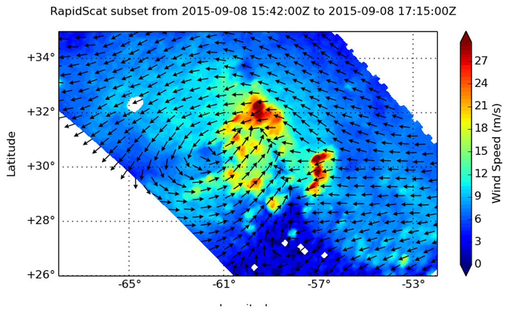
Sep. 10, 2015 – NASA’s RapidScat Looks at Tropical Storm Henri’s Winds
NASA’s RapidScat instrument analyzed the sustained surface winds of Tropical Storm Henri on Sept. 8 as the storm was intensifying.
When the International Space Station flew over Tropical Depression 8 in the Eastern Atlantic Ocean on September 8 at 1p.m. EDT, NASA’s RapidScat instrument aboard captured data on the storm’s surface winds. RapidScat showed that there were tropical-storm-force winds north and east of the center near 27 meters per second (60.4 mph/97.2 kph). However, sustained winds on the west and southwestern quadrants were near 12 meters per second (26.8 mph/43.2 kph) or less.
At 11 p.m. EDT that night, Tropical Depression 8 intensified and became a tropical storm and was renamed Henri.
By 11 a.m. EDT (1500 UTC) on September 10 the center of Tropical Storm Henri was located near latitude 32.6 North, longitude 60.8 West. Henri is centered about 235 miles (375 km) east of Bermuda and 1,065 miles (1,700 km) south-southwest of Cape Race, Newfoundland, Canada.
Henri was moving toward the north near 9 mph (15 kph) is expected to continue in that direction and speed up through September 11. Maximum sustained winds were near 40 mph (65 kph) and some strengthening is forecast during the next 48 hours. The estimated minimum central pressure is 1008 millibars.
Henri may have just intensified into a tropical storm, but it’s facing challenges. Southwesterly vertical wind shear and dry air were limiting the amount of thunderstorm development near the storm’s center on September 10.
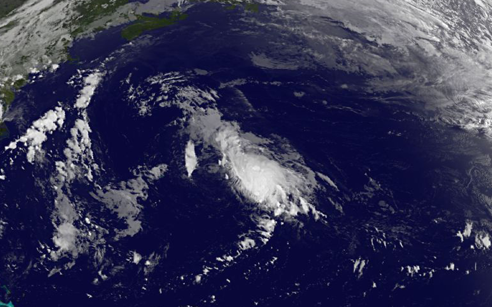
On September 10, satellite data from NOAA’s GOES-East satellite showed the cloud pattern of Henri remains disorganized with most of the convection sheared off to the east and northeast of the center.
The National Hurricane Center expects that wind shear to ease as Henri moves over warm water, giving it the opportunity to strengthen in the next day or two before weakening again.
Rob Gutro
NASA’s Goddard Space Flight Center
Sep. 09, 2015 – NASA Takes an Infrared Baby Picture of Atlantic’s Tropical Depression 8
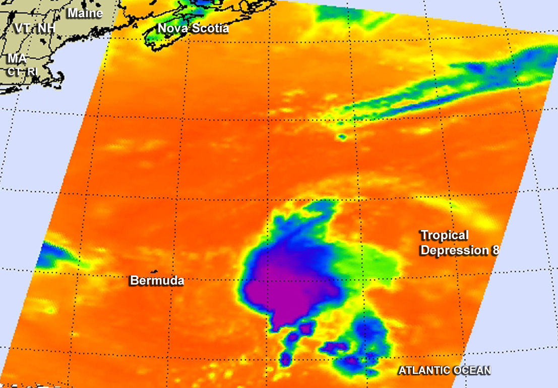
NASA’s Aqua satellite captured a “baby picture” of the eighth tropical depression of the Atlantic Ocean Hurricane Season.
On Sept. 9 at 5:53 UTC (1:53 a.m. EDT), the AIRS (Atmospheric Infrared Sounder) instrument aboard NASA’s Aqua satellite provided an infrared look at newborn Tropical Depression 8. AIRS data showed the coldest cloud top temperatures near -63F/-53C were being pushed east of the center of circulation.
The National Hurricane Center (NHC) noted that “the depression remains sheared, with the low-level center located just to the west of the western edge of the main area of deep convection. The vertical shear over the depression, which is currently near 20 knots (23 mph/37 kph) is forecast to diminish in 24 to 48 hours.”
At 11 a.m. EDT (1500 UTC) on September 9, the center of Tropical Depression Eight (TD8) was located near latitude 30.7 North, longitude 60.8 West. That’s about 260 miles (420 km) east-southeast of Bermuda. Maximum sustained winds were near 35 mph (55 kph) with higher gusts. The National Hurricane Center (NHC) forecast calls for some strengthening during the next 48 hours, and the depression is expected to become a tropical storm later on September 9. The estimated minimum central pressure is 1011 millibars.
When TD8 reaches tropical storm status it will be renamed “Henri.”
The depression was drifting toward the east-southeast near 3 mph (6 kph). NHC expects TD8 to move in a northerly direction. On the forecast track, the center will pass well east of Bermuda at night on September 9.
In three days, by September 12, TD8 is forecast to be over water temperatures near 17 degrees Celsius (62.6 Fahrenheit). Tropical cyclones need sea surface temperatures of at least 26.6C (80F) to maintain strength. As a result of the cooler sea surface temperatures, the NHC expects it to be an extra-tropical storm by that time.