


Farmers, researchers, meteorologists and others now have access to high-resolution NASA data on soil moisture, thanks to a new tool developed by the U.S. Department of Agriculture (USDA)’s National Agricultural Statistics Service (NASS) in collaboration with NASA and George Mason University.
The tool, Crop Condition and Soil Moisture Analytics (Crop-CASMA), provides access to high-resolution data from NASA’s Soil Moisture Active Passive (SMAP) mission and the Moderate Resolution Imaging Spectroradiometer (MODIS) instrument in a user-friendly format. Soil moisture data are critical for professionals in the agriculture and natural resources sectors who use soil moisture in tandem with other data to plan crop planting, forecast yields, track droughts or floods, and improve weather forecasts. Crop-CASMA is available for free online at https://cloud.csiss.gmu.edu/Crop-CASMA/.
The tool provides more thorough spatial coverage and consistency than other soil moisture measurement methods, said Rajat Bindlish, a research associate in Earth science remote sensing at NASA’s Goddard Space Flight Center in Greenbelt, Maryland.
“Soil moisture is a very important piece of information for agricultural yield and productivity,” said Bindlish. “This will provide a means of using NASA remote sensing data to guide predictions of moisture conditions and water availability. Information on the field conditions is important for agricultural operations.”
Some of Crop-CASMA’s primary users will be USDA NASS researchers and statisticians, who release weekly Crop Progress Reports that currently classify states into moisture categories (very short, short, adequate, surplus) to aid farmers and farm managers. The reports also track crops’ health and growing progress.
USDA researchers and statisticians will incorporate the tool into applications from spotting flooded fields to identifying conditions that might prevent planting, said NASS Spatial Analysis Research lead Rick Mueller.
“There are also challenges deriving early season crop acreage estimates using remote sensing methods,” Mueller said. “Crop-CASMA can help identify areas that could not be planted because of wet, saturated, frozen, excessively dry, or inaccessible fields resulting in improved planted statistical acreage estimates.”
In addition to supporting agricultural operations, it will enable research into sustainability and the impact of extreme weather events, Mueller said. “These satellite-derived vegetation condition indices and soil moisture condition maps show first-hand the ever-changing landscape of U.S. agriculture.”
The tool is formatted to be accessible to private users, including farmers, researchers and students, said Crop-CASMA project leader Zhengwei Yang, a USDA geographer and co-investigator of the High-Resolution Soil Moisture Development Project.
“We created an easy-to-use interface that requires little technical background to use,” said Yang. “There’s a tool to select an area and create a map you can save as a PDF, and you can also download data from the web to input into your model.”
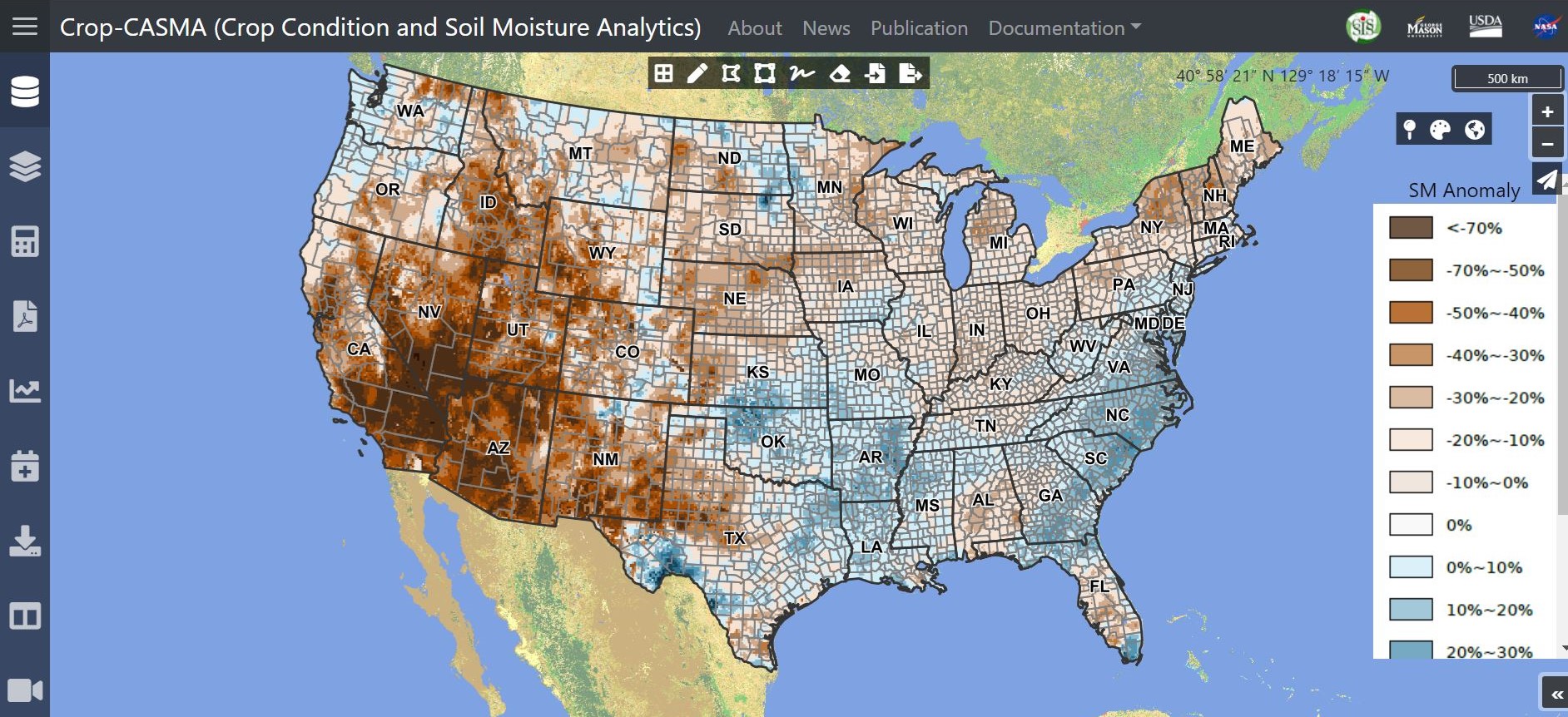
The SMAP data that are the foundation for Crop-CASMA are from the topsoil and rootzone levels, or from the surface to roughly 3 feet (1 meter) underground. Raw SMAP data have a 36-kilometer (roughly 20-mile) spatial resolution, meaning each data “footprint” is about the size of a county. The team also developed a data analysis method to estimate a higher-resolution soil moisture product using SMAP and land surface data, giving users information at 1-kilometer (0.62-mile) resolution.
Having the data in finer resolution allows users to more accurately pinpoint areas of high or low moisture, said Yang.
“Our current reports are at the state level,” Yang said. “One state may be categorized on average as ‘wet,’ but the whole state might not actually be wet. For instance, one area of a state might be wet, while another might be dry. These new data deliver localized moisture readings – this is what matters to the farmer.”
Crop-CASMA was developed in cooperation with the Center for Spatial Information Science and Systems (CSISS) at George Mason University, NASA’s Goddard Space Flight Center, and NASA’s Jet Propulsion Laboratory (JPL) in southern California. JPL manages the SMAP mission for NASA, and Goddard produces the SMAP 9-km rootzone and 1-km surface soil moisture products. Hosted and maintained by the CSISS, the online tool is operated by NASS’s Research and Development Division.
This work was also supported by NASA’s Western Water Applications Office (WWAO) and the NASA Terrestrial Hydrology Program. WWAO’s mission is to improve how water is managed in the arid western U.S., and the tool is part of a portfolio of water projects that use the power of remote sensing to deliver new solutions to water managers on issues including drought, agriculture, snowpack and water supplies.
“We know from our water partners in the western U.S. that there is a critical need for soil moisture data,” explained Indrani Graczyk, manager of WWAO. “This project was a great opportunity to partner with the USDA to get NASA data directly into the hands of farmers, and we were happy to support it.”
This collaboration is part of a larger, recently-signed agreement between USDA and NASA to jointly strengthen agricultural and Earth science research.
“Having the SMAP soil moisture data going directly to the users at NASS realizes one of the key goals of the mission,” said Simon Yueh, SMAP project scientist at JPL. “A strong collaboration between NASA and USDA has made this possible.”
By Teresa White, USDA’s National Agricultural Statistics Service, Washington, D.C.
Jane Lee, NASA’s Jet Propulsion Laboratory, Pasadena, Calif.
Jessica Merzdorf, NASA’s Goddard Space Flight Center, Greenbelt, Md.