


Satellite Movie Shows Hawaii Hurricane Hilda’s Last Hoorah
Credits: NASA/NOAA’s GOES Project
The once hurricane Hilda weakened to a remnant low pressure area early on Friday, August 14, 2015. Images generated from NOAA’s GOES-West satellite were made into an animation that showed the “last Hoorah” of Hilda as it weakened into a low pressure area on August 14, south of the Big Island of Hawaii.
NOAA’s GOES-West satellite sits in a fixed position over the eastern Pacific Ocean and monitors weather in the western U.S. and the central and eastern Pacific Ocean. Visible and infrared imagery from August 9 through August 14 were compiled and made into an animation at NASA/NOAA’s GOES Project at the NASA Goddard Space Flight Center in Greenbelt, Maryland. The animation showed Hilda in her prime as a hurricane, then moving to the northwest toward Hawaii where the storm encountered wind shear that weakened the storm to a tropical storm, then a depression and finally a remnant low pressure area.
The effects of wind shear on the storm can be seen in the animation, as clouds were pushed east of the center.
At 8 a.m. EDT (2 a.m. HST) on Friday, August 14, 2015, the remnant low associated with former tropical cyclone Hilda, centered about 330 miles south-southwest of Hilo, Hawaii, continues to generate disorganized showers and thunderstorms.
NOAA’s Central Pacific Hurricane Center noted that re-development of this system is not anticipated due to strong upper-level winds as it tracks west-southwest around 13 mph over the next couple of days.
Rob Gutro
NASA’s Goddard Space Flight Center
Aug. 13, 2015 – NASA’s RapidScat Sees Diminishing Winds in Tropical Storm Hilda
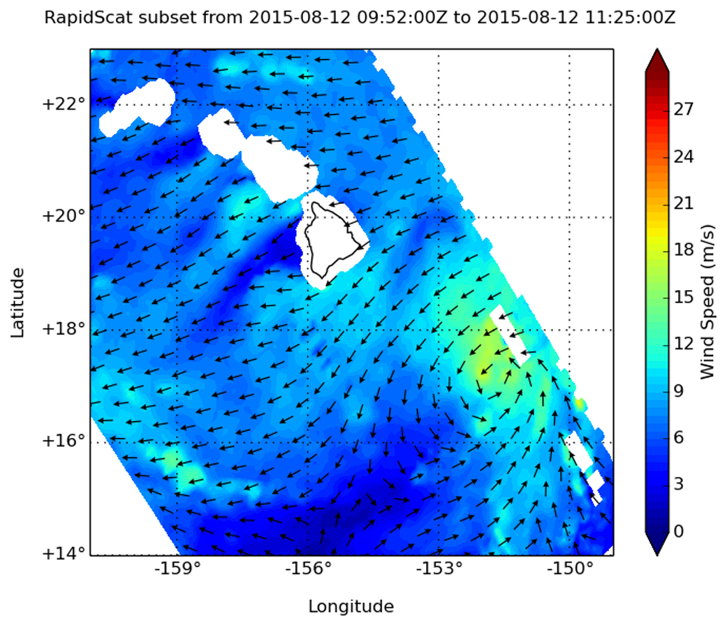
As Tropical Storm Hilda creeps closer to the Big Island of Hawaii, NASA’s RapidScat instrument that flies aboard the International Space Station observed its diminishing winds.
RapidScat gathers data on surface winds occurring over the ocean. On Wednesday, August 12 at 1100 UTC (7 a.m. EDT), RapidScat observed tropical-storm-force winds on Hilda’s northwestern side. Those winds were as strong as 20 meters per second (45 mph/72 kph) while weaker sustained winds were occurring around the rest of the storm.
By 0900 UTC (5 a.m. EDT) on August 13, maximum sustained winds were holding near 45 mph (75 kph), but NOAA’s Central Pacific Hurricane Center (CPHC) forecast calls for Hilda to gradually weaken through late Friday, August 14.
Hilda’s center was located near latitude 17.2 north…longitude 152.5 west. That puts the center of Hilda about 240 miles (390 km) southeast of Hilo, Hawaii and about 450 miles (725 km) southeast of Honolulu, Hawaii. Hilda was moving toward the west near 5 mph (7 kph) and is expected to move to the west-southwest later in the day through August 14. The estimated minimum central pressure is 1003 millibars.
The center of Hilda is now expected to stay south of the Big Island and move to the west-southwest. However, RapidScat showed that the strongest winds were occurring north of the center.
NOAA’s CPHC said that east and southeast facing shores of portions of the Hawaiian Islands will experience swells and large surf. Hilda may produce heavy rainfall along and north of its path. These rains could result in life threatening flash floods and mud slides across portions of the Hawaiian Islands tonight (August 13) into Saturday, August 15.
For updated forecasts, watches and warnings, visit CPHC’s website: http://www.prh.noaa.gov/
Rob Gutro
NASA’s Goddard Space Flight Center
Aug. 12, 2015 – NASA Sees Heavy Rain in Hurricane Hilda, South Of Hawaii
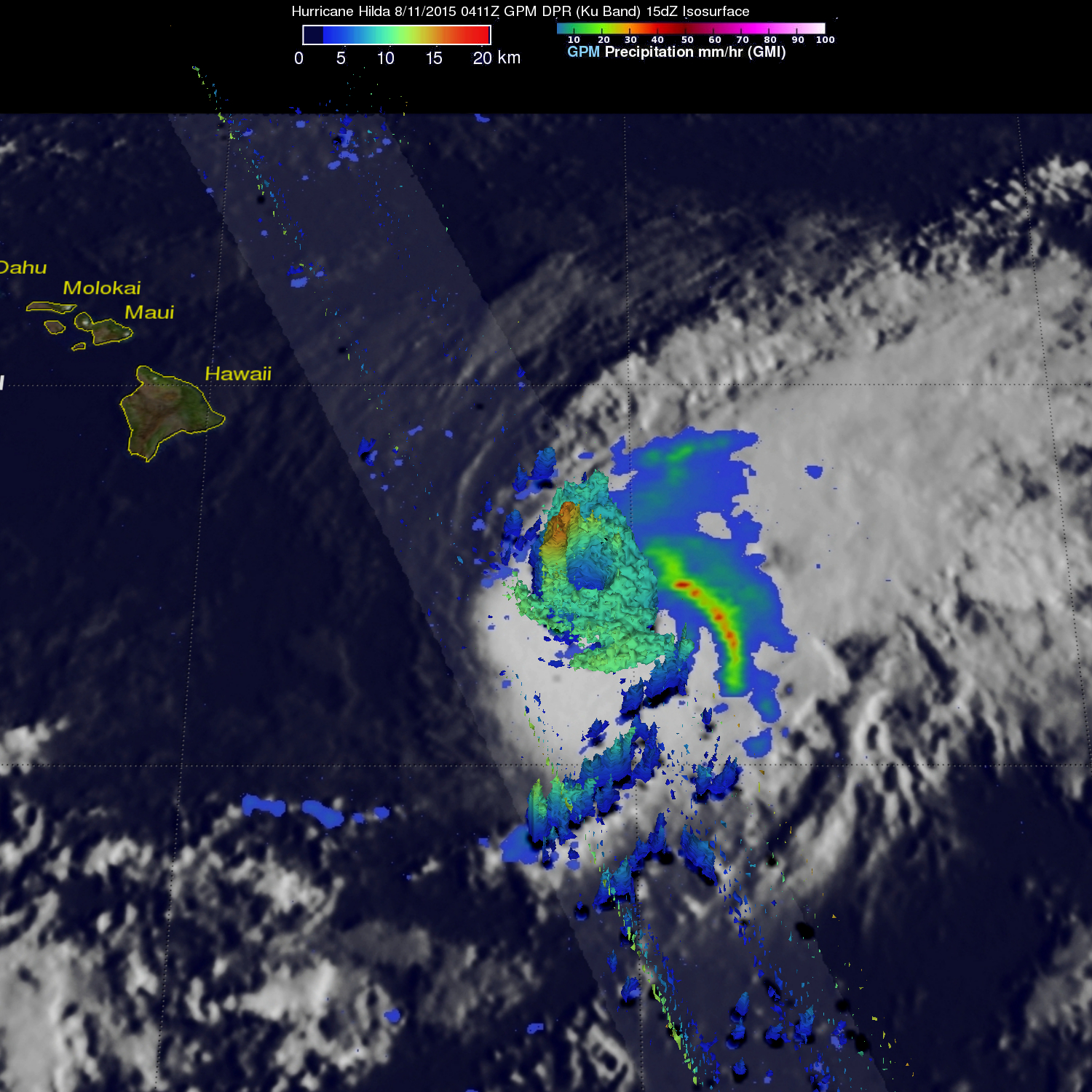
Hurricane Hilda has been on a weakening trend and by August 12 it weakened to a Tropical Storm. When it was still a hurricane though, NASA satellite data showed that the northern side of the storm contained towering thunderstorms that were dropping heavy rainfall.
Hilda had winds of about 80 knots (92 mph) when the GPM core observatory satellite passed above on August 11, 2015 at 0411 UTC (August 10, 2015 at 6:11 p.m. HST). Rainfall data from GPM’s Microwave Imager (GMI) and Dual-Frequency Precipitation Radar (DPR) instruments were combined with an infrared image of clouds from NOAA’s GOES West satellite taken at 0400 UTC on August 11. The combined image showed the cloud extent and rainfall within the storm. GPM’s DPR revealed that storms north of hurricane Hilda’s eye were dropping rain at a rate of over 149.4 mm (5.9 inches) per hour.
At NASA’s Goddard Space Flight Center in Greenbelt, Maryland that data from GPM’s radar data (DPR Ku band) were used to make a 3-D image that showed the heights of the thunderstorm tops within Hilda. The highest cloud tops were found near altitudes of over 16.5 km (10.2 miles) in powerful storms in the northwestern side of Hilda’s eye wall.
As Hilda neared the big Island of Hawaii, NOAA’s Central Pacific Hurricane Center posted a tropical storm watch for Hawaii County.
At 11 a.m. EDT/5 a.m. HST/1500 UTC on Wednesday, August 12, Hilda’s maximum sustained winds had dropped to 45 mph (75 kph) and further weakening was forecast. The center of Tropical Storm Hilda was located near latitude 17.5 north and longitude 152.0 west. Hilda was moving toward the northwest near 5 mph (7 kph) and is expected to turn west through August 13.
Hilda is forecast to be a tropical depression tonight (August 12) or Thursday (August 13) and a remnant low by Thursday night.
Rob Gutro
NASA’s Goddard Space Flight Center
Aug. 11, 2015 – NASA’s RapidScat Sees Hurricane Hilda’s Strongest Winds on Northern Side
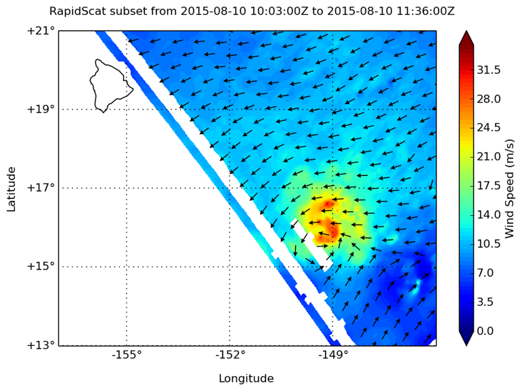
The RapidScat instrument that flies aboard the International Space Station identified Hurricane Hilda’s strongest winds on the northern side of the storm.
RapidScat measures surface winds over ocean areas, and identifying the location of the strongest winds is helpful to forecasters, mariners and populated areas near the storm.
RapidScat gathered wind speed and direction data on Hurricane Hilda on Aug. 10 at 1100 UTC (7 a.m. EDT). RapidScat measured strongest sustained winds north of the center at around 33 meters per second/73 mph/118.9 kph).
On August 11 at 0900 UTC (5 a.m. EDT/11 p.m. HST on Aug. 10), Hurricane Hilda’s maximum sustained winds were near 90 mph (150 kph), but the Central Pacific Hurricane Center forecast calls for steady weakening over the next two days. Hilda forecast to weaken to a tropical storm by tonight, August 11. .
The center of Hurricane Hilda was located near latitude 17.1 north and .longitude 150.9 west. That’s about 330 miles (530 km) east-southeast of Hilo, Hawaii and about 540 miles (870 km) east-southeast of Honolulu Hawaii. Hilda was moving toward the northwest near 5 mph (7 kph) and is expected to turn to the west-northwest late on August 12. The estimated minimum central pressure is 981 millibars.
Hilda’s effects are expected to include large ocean swells, and large and potentially life threatening surf along east and southeast facing shores of portions of the Hawaiian Islands over the next couple of days.
Hilda is expected to produce very heavy rain over portions of the Hawaiian Islands from Wednesday, August 12 into the weekend (August 15 and 16). These rains could cause life threatening flash floods and mudslides. For updated forecasts, visit CPHC: http://www.prh.noaa.gov/hnl/cphc/
Rob Gutro
NASA’s Goddard Space Flight Center
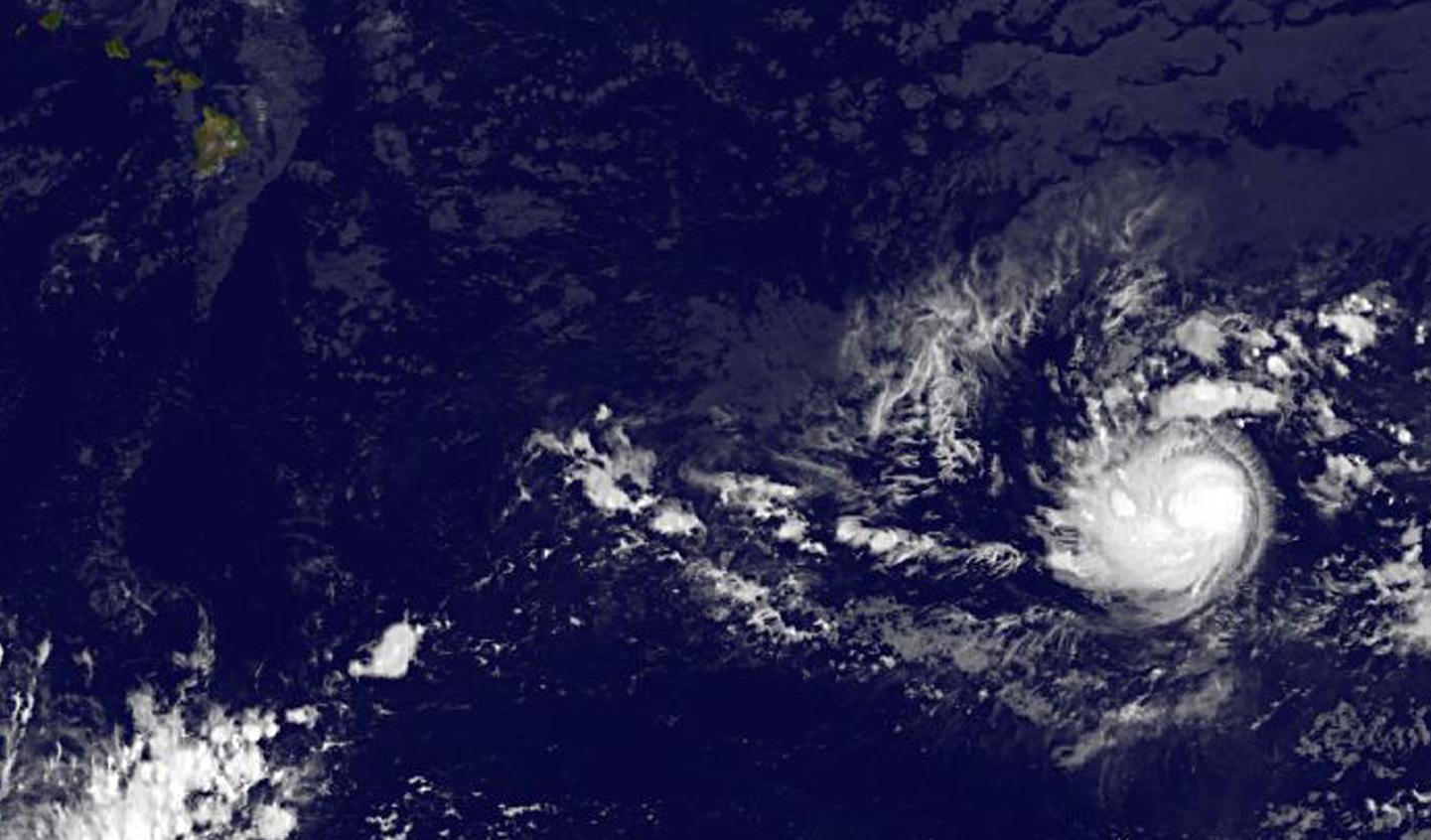
Aug. 10, 2015 – NASA Stares Hurricane Hilda in the Eye

NASA’s Terra satellite passed over Hurricane Hilda and captured an image that clearly showed the storm’s eye. Although there are currently no watches or warnings in effect, Hilda is expected to cause rough surf as it moves toward the Hawaiian Islands over the next several days.
The Moderate Resolution Imaging Spectroradiometer or MODIS instrument aboard NASA’s Terra satellite captured an image of Hurricane Hilda on August 8 at 20:25 UTC (4:26 p.m. EDT). The MODIS image showed that Hilda had a cloud-free eye with a strong thunderstorms circling the center. The image was created by the MODIS Rapid Response Team at NASA’s Goddard Space Flight Center, Greenbelt, Maryland.
Hurricane force winds extended outward up to 25 miles (35 km) from the center and tropical storm force winds extended outward up to 70 miles (110 km).
On Monday, August 10, 2015 at 5 a.m. EDT (0900 UTC/11 p.m. EDT HST, August 9), Hilda’s maximum sustained winds were near 100 mph (155 kph). The center of Hurricane Hilda was located near latitude 15.7 north and longitude 149.1 west. That puts the center of Hilda about 480 miles (775 km) southeast of Hilo, Hawaii. Hilda was moving toward the west-northwest near 9 mph (15 kph) and is expected to turn to the northwest over the next couple of day. The estimated minimum central pressure is 974 millibars.
Hurricane Hilda is creating large surf along east and southeast facing shores of the main Hawaiian Islands over the next couple of days.
Forecasters at the Central Pacific Hurricane Center (CPHC) expect steady weakening over the next 48 hours. Hilda is forecast to weaken to a tropical storm on Tuesday, August 11 and by Thursday, August 13 Hilda is expected to move over the Big Island as a depression on its trek to the west-northwest.
Rob Gutro
NASA’s Goddard Space Flight Center
Aug. 07, 2015 – Satellite View of a Stronger Tropical Storm Hilda
Tropical Storm Hilda is moving from the Eastern Pacific into the Central Pacific Ocean and strengthening as she moves west. A satellite image showed the rounded storm over 1,300 miles east-southeast of Hawaii.
NOAA’s GOES-West satellite captured an infrared image of a rounded Tropical Storm Hilda on August 7 at 8 a.m. EDT. The GOES satellite image shows a rounded storm with the highest thunderstorms in the eastern side of the storm.
National Hurricane Center forecaster Beven noted “The system continues to have a sheared appearance, which is somewhat surprising since the available data show less than 10 knots of vertical wind shear.”
At 800 AM PDT (1500 UTC), the center of Tropical Storm Hilda was located near latitude 12.8 North, longitude 136.7 West. That puts the center of Hilda about 1,310 miles (2,105 km) east-southeast of Hilo, Hawaii, and about 1,890 miles (3,040 km) west-southwest of the southern tip of Baja California, Mexico.
Hilda is moving toward the west near 13 mph (20 kph). Maximum sustained winds are near 60 mph (95 km/h) with higher gusts. Strengthening is forecast during the next 48 hours, and Hilda could become a hurricane later tonight, August 7 or on Saturday, August 8.The estimated minimum central pressure is 999 millibars.
Hilda is forecast to turn to the west-northwest and follow a similar track to Guillermo. The storm is expected to reach hurricane force on August 8 before weakening back to a tropical storm on August 11.
Rob Gutro
NASA’s Goddard Space Flight Center, Greenbelt, Md.
Aug. 6, 2015 – Satellite Sees Formation of Eastern Pacific’s Tropical Storm Hilda
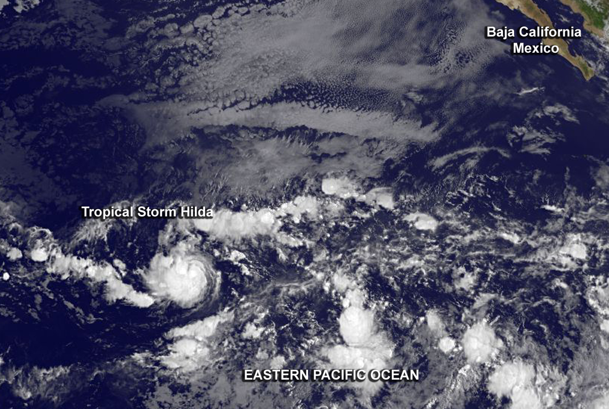
The GOES-West satellite captured images of Tropical Storm Hilda as it developed early on August 6.
A low pressure area organized into a depression early on August 6 and by 11 a.m. EDT (1500 UTC), it strengthened into a tropical storm and was named Hilda. In the GOES-West infrared image from1500 UTC (11 a.m. EDT), thunderstorms tightly surround the center of circulation.
The National Hurricane Center’s Forecaster Kimberlain noted “The cyclone’s cloud pattern has significantly increased in organization since late yesterday. There is now a small central mass of deep convection, with a band on the northern side of the circulation.”
At 800 AM PDT (1500 UTC), the center of Tropical Storm Hilda was located near latitude 12.7 North, longitude 132.3 West. That puts the center of Hilda about 1,630 miles or 2,620 km west-southwest of the southern tip of Baja California, Mexico, far from land. Hilda is moving toward the west near 13 mph (20 kph). This motion is expected to continue through tonight followed by a turn toward the west-northwest on Friday. The estimated minimum central pressure is 1004 millibars.
Maximum sustained winds have increased to near 40 mph (65 kph) and strengthening is forecast during the next 48 hours, Hilda is expected to be near hurricane strength by Saturday, August 8.
Rob Gutro
NASA’s Goddard Space Flight Center