


![Request for Information – Potential [Placeholder for Prize]](https://assets.science.nasa.gov/dynamicimage/assets/science/missions/a-step/FFR_Earth_Background_20251120%20.png?w=1024)


NASA ICB 2021 Awards
Invention of the Year
Winner: Government: National Airspace System Constraint Evaluation and Notification Tool (NASCENT) and Compact Thermal Imager (CTI) | Commercial: Automatic Dependent Surveillance Broadcast (ADS-B)
Center: Government: ARC and GSFC, respectively | Commercial: AFRC
Making Air Travel More Efficient
The National Airspace System Constraint Evaluation and Notification Tool, or NASCENT, suggests routes to bypass weather while avoiding restricted airspace, reducing congestion, and prioritizing safety. The system relies on observed air traffic controller behavior to reduce flight times and uses historically used flight paths to streamline approval by air traffic controllers. It operates within the Federal Aviation Administration’s current operating procedures, meaning there is no added cost to the national air transportation system infrastructure to use the tool. NASCENT could help improve efficiency in air traffic operations, reduce delays, save fuel, and decrease harmful emissions.
The technology has been licensed by several companies both for commercial and for research purposes. NASCENT was recognized as a co-winner for 2021 Invention of the Year in the government category. The project is led by Kapil Sheth at NASA’s Ames Research Center in California’s Silicon Valley.
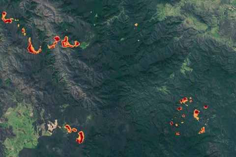
Sharpening NASA’s Eyes on Earth
A compact infrared sensor is giving NASA and industry a better look at Earth’s hotspots in a package small enough to fit on a miniature satellite.
The Compact Thermal Imager, or CTI’s, infrared detector technology is relatively easy and inexpensive to create, can be tuned to specific wavelengths, and is more sensitive than many other infrared detectors. CTI can also work at warmer temperatures, meaning it doesn’t need additional cooling equipment and can be placed on small satellites like CubeSats.
CTI has already flown on the International Space Station, where it took more than 15 million infrared images of Earth. Images from CTI-like sensors can help scientists and industry gather better data on things like wildfires and agriculture. Georgia-based Cybercorps LLC licensed CTI in 2019, and plans to offer real-time agricultural data for farmers, resource managers, first responders, and other interested user groups by flying CTI on a CubeSat to capture thermal images of Earth’s surface.
CTI was recognized as a co-winner for 2021 Invention of the Year in the government category, and is led by Murzy Jhabvala, Donald Jennings, and Compton Tucker. CTI was developed at NASA’s Goddard Space Flight Center in Greenbelt, Maryland, with funding from the center’s Internal Research and Development fund, NASA’s Earth Science Technology Office, and NASA’s Small Business Innovation Research program, which funded QmagiQ to develop some of the sensor components.
Advancing Safe Flight for Uncrewed Aircraft
Uncrewed, remotely piloted aircraft – called unmanned aircraft systems, or UAS – have their own set of challenges to overcome when designing a safe flight path.
A NASA collision-avoidance technology combines algorithms, sensors, and software integrated on UAS. It offers improved traffic situational awareness, real-time weather monitoring, and navigation – all designed for the short-range trajectories most often used by UAS. The algorithm can automatically avoid collisions and route the aircraft back on its previous course once the potential collision is well clear.
The technology has been licensed by a private company, Vigilant Aerospace Systems, which has used it to provide detect-and-avoid and airspace management solutions to two Unmanned Aircraft Integration Pilot Programs. The company also used the technology to provide portable airspace safety support to the not-for-profit Humanitarian Drones team that helped with relief efforts and to document damage in the wake of Hurricane Harvey in 2017.
The technology – called Automatic Dependent Surveillance Broadcast (ADS-B) system with Radar for Ownship and Traffic Situational Awareness – was the 2021 Invention of the Year in the commercial category, recognizing a NASA technology that has a commercial license in place. The technology was developed at NASA’s Armstrong Flight Research Center in Edwards, California, by a team led by Ricardo Arteaga.
Software of the Year Award
Winner: Copernicus Spacecraft Trajectory Design and Optimization System
Center: JSC
Planning a Path Through Space
Plotting a mission’s path through space depends on a complicated mix of factors including destination, fuel, and the number of spacecraft involved.
The Copernicus Spacecraft Trajectory Design and Optimization System streamlines that process. Copernicus lets teams model, design, and optimize paths through space for their missions – from simpler flights to more complicated missions that might involve several spacecraft with different propulsion systems.
Copernicus also allows teams to look at how gravity from multiple celestial bodies – for example, Earth and the Moon – might influence mission design. Engineers at NASA’s Johnson Space Center in Houston are using Copernicus as their primary tool for designing trajectories for Artemis missions using Orion.
Copernicus, a project of NASA Johnson, was selected as the 2021 NASA Software of the Year. Copernicus was originally developed at the University of Texas at Austin in 2001 by Dr. Cesar Ocampo with NASA support, and primary development was transferred to NASA Johnson in 2007, where it has been under continuous development ever since. At Johnson, the Copernicus project is led by Gerald Condon, and the lead developer is Jacob Williams. Organizations interested in obtaining Copernicus can request it from NASA Technology Transfer.