


![Request for Information – Potential [Placeholder for Prize]](https://assets.science.nasa.gov/dynamicimage/assets/science/psd/solar/2023/09/s/solarsystem_0.jpg?w=1024)


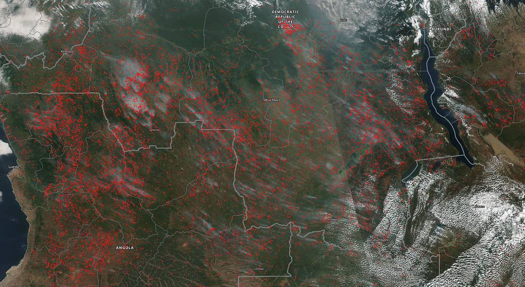
Fires are commonplace in Africa at this time of year. Even the thousands of them as seen in this NOAA/NASA Suomi NPP satellite image. Why? The most likely explanation is the type of agricultural practice that is employed in this area of the world. Called “slash and burn” this type of field clearing is both inexpensive and low tech. It also works. The resulting layer of ash generated by the slash and burn practice provides the newly-cleared land with a nutrient-rich layer to help fertilize crops. That is not to say that every fire in this image is controlled or contained. Often fires set to renew fields can grow out of control as winds or storms move the fire out of the area that was to be cleared. What is definite is that these fires have been burning for at least a month. Looking backward in NASA’s Worldwide satellite imagery application, the basic number of fires appears constant for the past 30 days. Which brings up another point. While fire helps enhance crops and grasses for pasture, the fires also produce smoke that degrades air quality. The European Space Agency (ESA) published an article on February 04, 2019 about fires in Africa. The article mentioned, “It is currently estimated that fires contribute 25–35% of total annual greenhouse gas emissions to the atmosphere so more precise information gained from satellite-based scar-burn maps could help to better understand how they add to the greenhouse effect. The authors (of the study cited in this article) focused on sub-Saharan Africa as the region accounts for around 70% of burned area worldwide according to global satellite databases, making it the ideal testbed for evaluating the potential for improving the understanding of global impacts of fire.”
NOAA/NASA’s Suomi NPP satellite collected this natural-color image using the VIIRS (Visible Infrared Imaging Radiometer Suite) instrument on June 10, 2019. NASA’s Earth Observing System Data and Information System (EOSDIS) Worldview application provides the capability to interactively browse over 700 global, full-resolution satellite imagery layers and then download the underlying data. Many of the available imagery layers are updated within three hours of observation, essentially showing the entire Earth as it looks “right now.” Actively burning fires, detected by thermal bands, are shown as red points. Image Courtesy: NASA Worldview, Earth Observing System Data and Information System (EOSDIS). Caption: Lynn Jenner with information from the ESA Sentinel-2 website.