


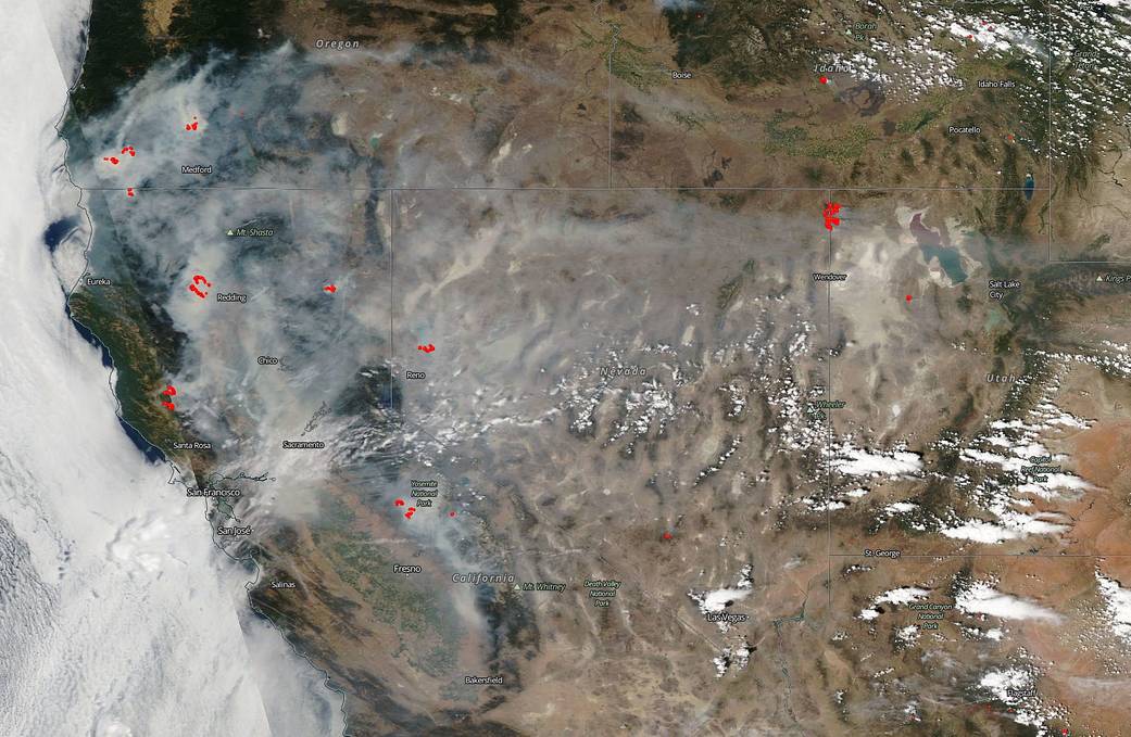
NASA’s Aqua satellite captured this natural color image of the fires in California and the resultant smoke that has shrouded the state and swept eastward as far as Salt Lake City and still moving. Dangerous and deadly fires have broken out across the state including the Carr fire inferno and the long-standing Ferguson fire near Yosemite National Park as well as the Mendocino Complex north of Santa Rosa.
The Carr fire located near Redding, California has exploded over the week from its inception. Now at 98,724 acres and is 20% contained. Six people have died as a result of this deadly fire and the Carr fire has also destroyed 723 residences, 3 commercial buildings, and 240 outbuildings with over 5,000 more structures in danger. There are a staggering number of mandatory evacuations that can be found at the Shasta County Sheriff’s website. Over 3,300 firefighters are engaged in this effort. Weather forecasts are not favorable for fighting this or any of the other fires in California. The hot, dry weather that contributed to the deadly California firestorm shows no sign of letting up into the first part of August.
Firefighters have been attacking the Ferguson blaze near Yosemite National Park since July 13. The fire has consumed more than 56,659 acres and was 30 percent contained on Saturday night, according to Inciweb. Much of the fire is burning in steep, rugged terrain with little to no access roads. 3,766 personnel that are currently engaged on the fire. There has been 2 fatalities and 7 injuries to date. 1 structure has been destroyed. As with the Carr fire, the hot, dry weather coupled with winds makes fighting this or any blaze incredibly difficult.
The River fire (part of the Mendocino Complex) located north of Santa Rosa broke out on July 27, 2018. This fire has consumed 20,911 acres and is currently 5% contained. Six residents and one outbuilding have been destroyed with another 10,000 structures being threatened. Mandatory evacuation orders are in place. Firefighters continue to battle both fires. Crews worked throughout the night to reinforce containment lines while the fire behavior remained extreme. Weather conditions will continue to challenge firefighters as hot, dry and windy conditions persist. The Ranch fire (the other half of the Mendocino Complex) is 35,076 acres in size and is 5% contained. The cause of both fires is under investigation. There are mandatory evacuations in place for both fires.
The Governor of California, Gov. Edmund Brown, has declared a state of emergency in Lake, Mendocino and Napa Counties due to the number and ferocity of the fires currently plaguing these counties.
NASA’s EOSDIS provides the capability to interactively browse over 600 global, full-resolution satellite imagery layers and then download the underlying data. Many of the available imagery layers are updated within three hours of observation, essentially showing the entire Earth as it looks “right now”. This natural-color satellite image was collected by the Aqua satellite on July 29, 2018. Actively burning areas, detected by thermal bands, are outlined in red. NASA image courtesy NASA/Goddard Space Flight Center Earth Science Data and Information System (ESDIS) project. Caption: Lynn Jenner with information from CAL fire and Inciweb.