


![Request for Information – Potential [Placeholder for Prize]](https://assets.science.nasa.gov/dynamicimage/assets/science/missions/a-step/FFR_Earth_Background_20251120%20.png?w=1024)


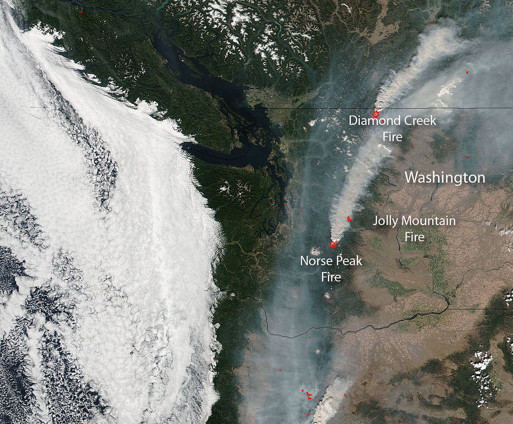
NOAA/NASA’s Suomi NPP satellite’s Visible Infrared Imaging Radiometer Suite (VIIRS) instrument captured this image of several major fires in Washington state on August 29, 2017. The three highlighted fires are the Diamond Creek fire, the Jolly Mountain fire and the Norse Peak fire. Inciweb lists nine separate fires going on in the state but these three fires are the largest and the Norse Peak fire is currently spewing massive amounts of smoke into the atmosphere as evidenced in this image.
The Norse Peak fire began on August 11 with a lightning strike, in fact, thirteen fires were ignited by lightning in a series of storms on August 10th and 11th, in the vicinity of the William O. Douglas and Norse Peak Wilderness Areas on the Naches Ranger District of the Okanogan-Wenatchee National Forest. Two of the fires have reached significant size and remain active: the Norse Peak Fire and the American Fire). These fires are being managed collectively as “Norse Peak.” This collective fire is currently 13,210 acres and is still growing at a moderate pace. Hot, dry conditions which contributed to the start of this fire, continue to allow it to grow although a cold front is expected soon which will hopefully bring more moderate relative humidity.
The Diamond Creek fire is a human caused fire that began on July 23, 2017. It is currently at 33,728 acres and is 63% contained. The Diamond Creek Fire is burning within the Pasayten Wilderness approximately 12 air miles north of Mazama, Washington and 5.5 miles (8.9 kilometers) south of the Canadian border. The fire continued to move to the north and west with active burning during the night. Smoke continues to affect air quality in the upper Methow Valley.
The Jolly Mountain fire began on August 11 with a lightning strike. It is 5,164 acres in size. The area is critically dry having only received 1/10th of an inch of rain since the fire began. Fuels for the fire are extremely dry allowing the quick spread of fire. On August 29, helicopters and scooper planes dropped nearly 85,000 gallons of water on the Jolly Mountain Fire Aerial firefighting resources drop water on the fire perimeter to minimize spread and slow the fire’s progression. Evacuations south of the fire are in effect for several areas that are being threatened by the growth of the fire.
The Suomi NPP satellite is a joint mission between NASA and NOAA.
NASA image courtesy Jeff Schmaltz, MODIS Rapid Response Team. Caption: NASA/Goddard, Lynn Jenner with information of Inciweb.