


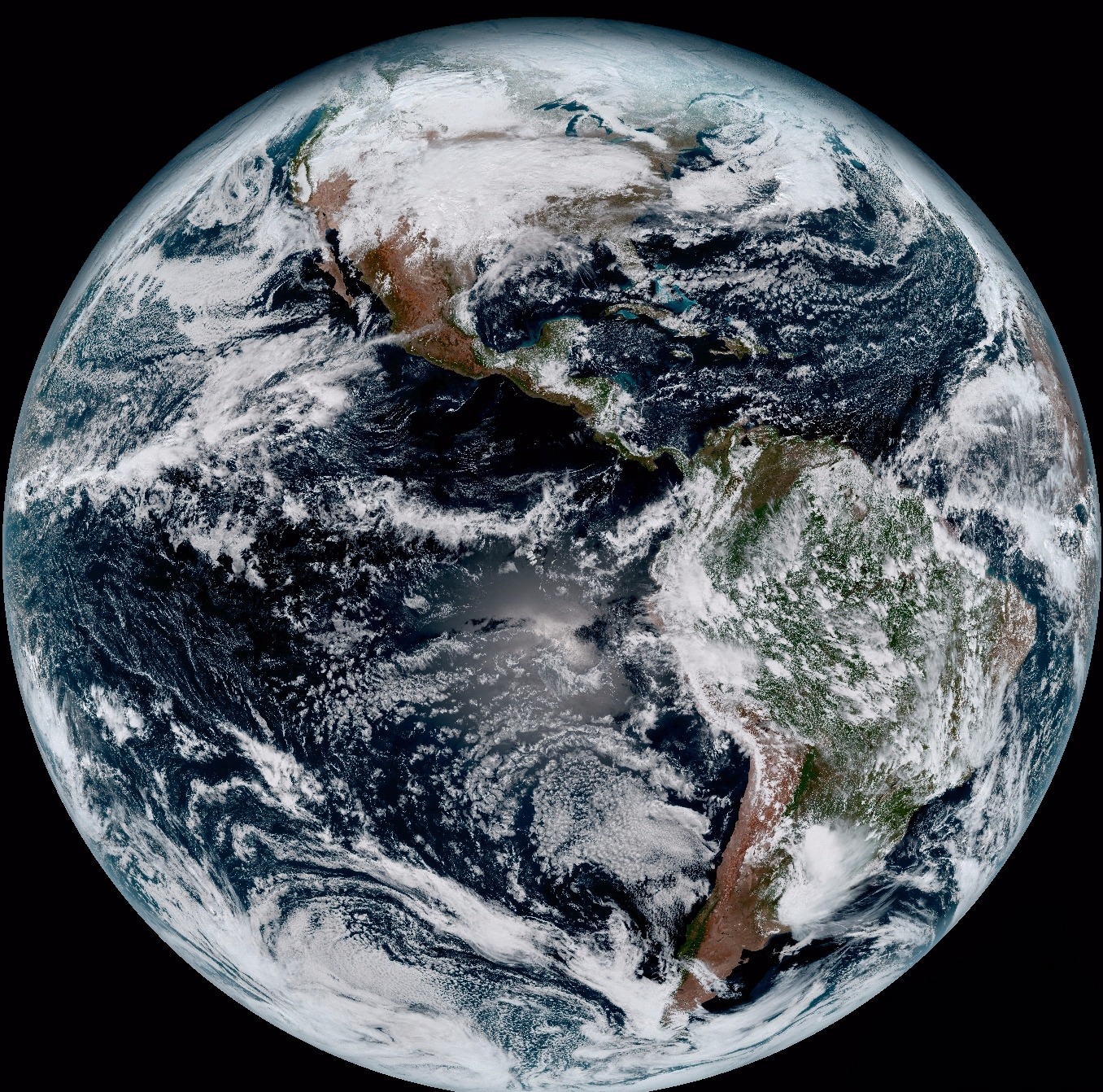
GOES-16, the first spacecraft in NOAA’s next-generation of geostationary satellites, has sent the first high-resolution images from its Advanced Baseline Imager (ABI) instrument. Included among them are a composite color full-disk visible image of the Western Hemisphere captured on January 15, 2017. Created using several of the ABI’s 16 spectral channels, the full-disk image offers an example the satellite’s advanced technology.
The ABI can provide a full disk image of the Earth every 15 minutes, one of the continental U.S. every five minutes, and has the ability to target regional areas where severe weather, hurricanes, wildfires, volcanic eruptions or other high-impact environmental phenomena are occurring as often as every 30 seconds. The ABI covers the Earth five-times faster than the current generation GOES imagers and has four times greater spatial resolution, allowing meteorologists to see smaller features of the Earth’s atmosphere and weather systems.
“Seeing these first images from GOES-16 is a foundational moment for the team of scientists and engineers who worked to bring the satellite to launch and are now poised to explore new weather forecasting possibilities with this data and imagery,” said Stephen Volz, Ph.D., NOAA’s assistant administrator for Satellite and Information Services, Silver Spring, Maryland. “The incredibly sharp images are everything we hoped for based on our tests before launch. We look forward to exploiting these new images, along with our partners in the meteorology community, to make the most of this fantastic new satellite.”
“The image is much more than a pretty picture, it is the future of weather observations and forecasting,” said Louis W. Uccellini, Ph.D., director, NOAA’s National Weather Service, Silver Spring. “High resolution imagery from GOES-16 will provide sharper and more detailed views of hazardous weather systems and reveal features that previous instruments might have missed, and the rapid-refresh of these images will allow us to monitor and predict the evolution of these systems more accurately. As a result, forecasters can issue more accurate, timely, and reliable watches and warnings, and provide better information to emergency managers and other decision makers.”
Along with the full-disk image of the Western Hemisphere, GOES-16 also captured:
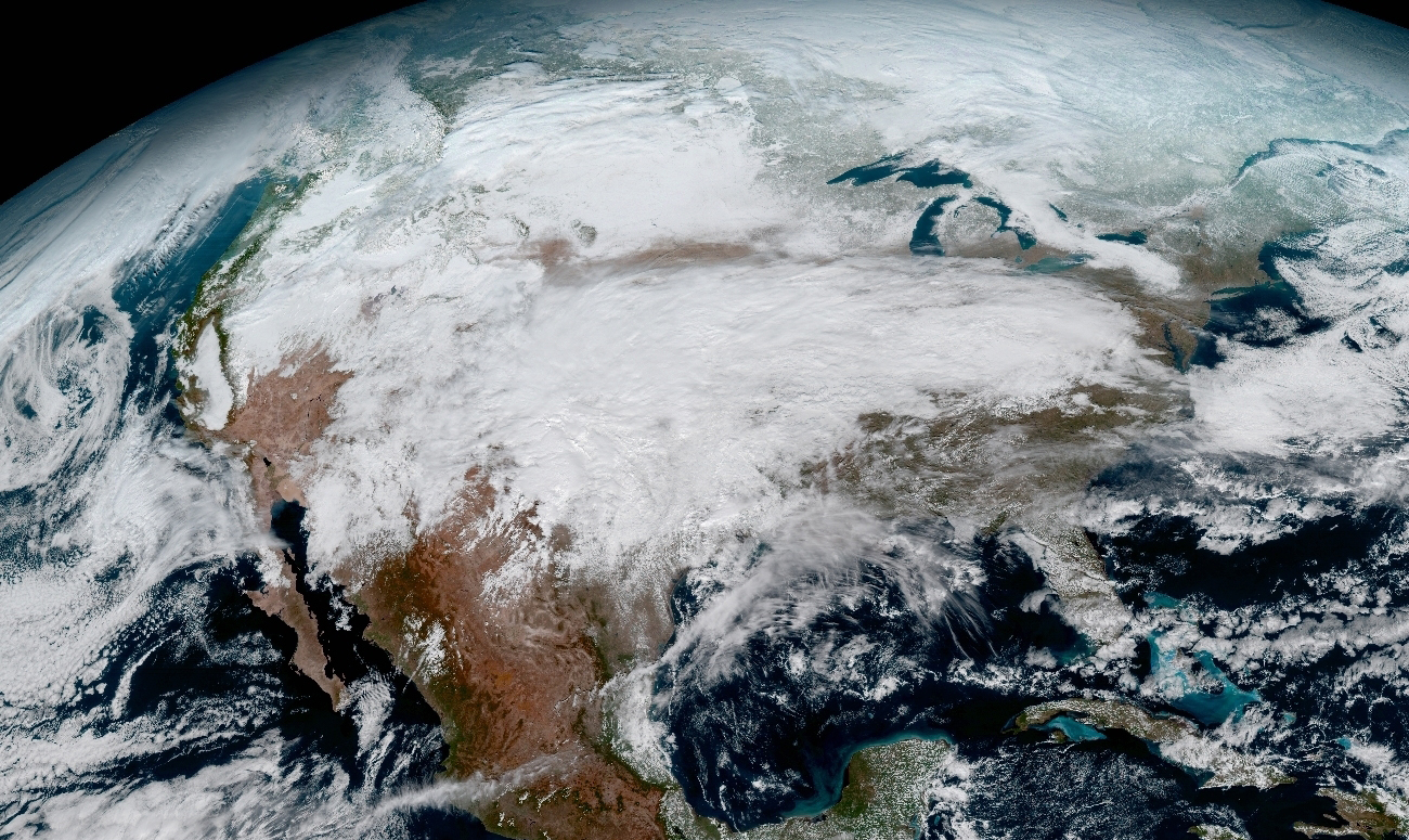
• An image of the continental United States showing the significant storm system that crossed North America on January 15, 2017
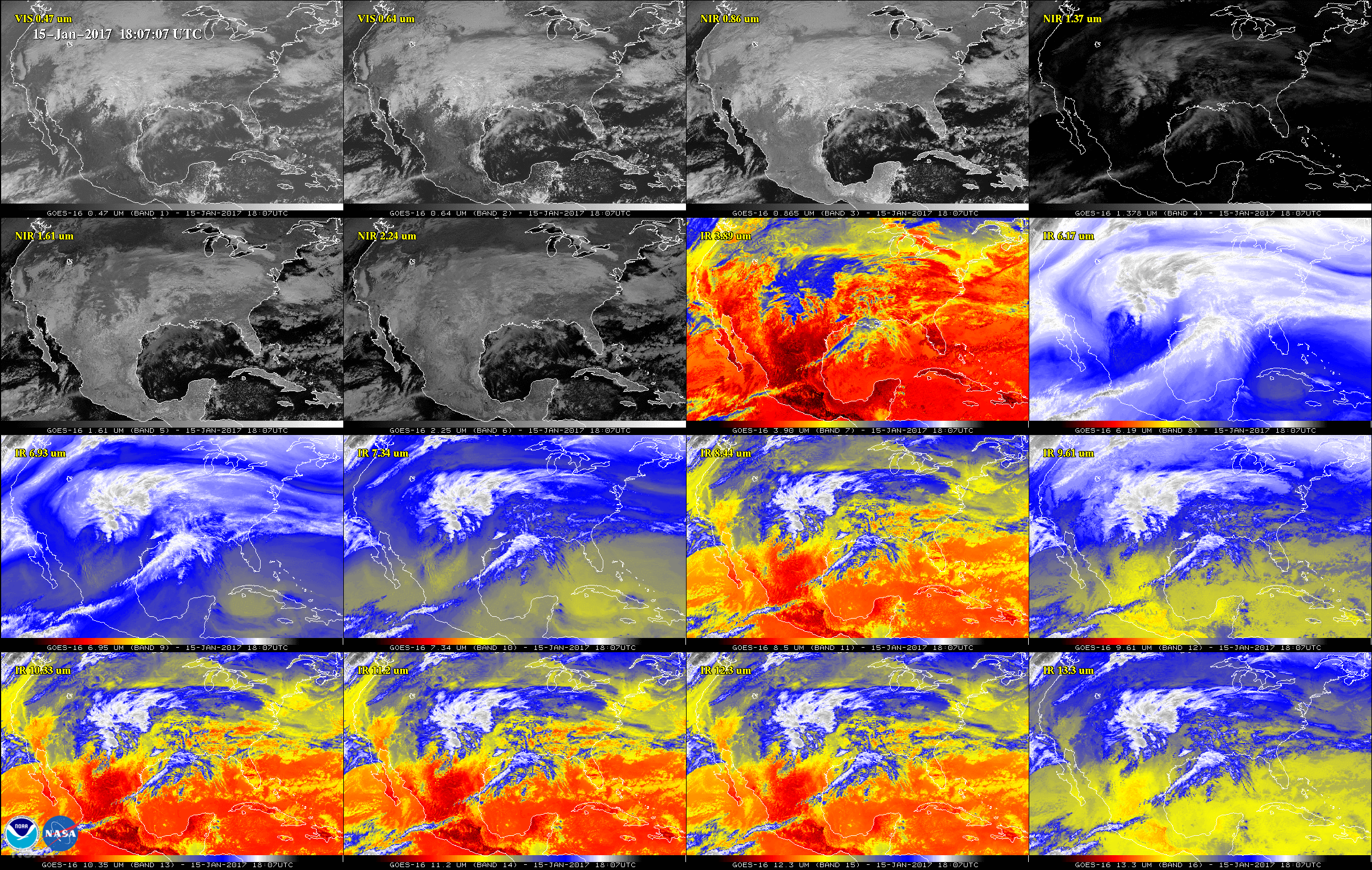
• A 16-panel image showing the continental United States in the two visible, four near-infrared and 10 infrared channels on ABI.
• An image showing dust blowing off the coast of Africa
• An image of the Caribbean and Florida that shows some of the shallows waters in the region.
• A view of Argentina, South America, in which mountain wave clouds can be seen in the southwestern part of the country.
NASA successfully launched GOES-R at 6:42 p.m. EST on November 19, 2016 from Cape Canaveral Air Force Station in Florida and it was renamed GOES-16 when it achieved orbit. GOES-16 is now observing the planet from an equatorial view approximately 22,300 miles above the surface of the Earth. In May, NOAA will announce the planned location for GOES-16 and by November 2017, GOES-16 will be operational in either the GOES-East or GOES-West position.
Following on the heels of GOES-16, formerly GOES-R, will be GOES-S, the next spacecraft in the series, which is planned for launch in Spring 2018. GOES-S is currently undergoing environmental testing at Lockheed Martin Corporation’s Littleton, Colorado, facility where it was built. A full set of environmental, mechanical and electromagnetic testing will take about one year to complete. After its initial on-orbit checkout the GOES-S satellite will be moved into the other operational position as GOES-17.
NOAA’s satellites are the backbone of its life-saving weather forecasts. GOES-16 will build upon and extend the more than 40-year legacy of satellite observations from NOAA that the American public has come to rely upon.
NOAA manages the GOES-R Series Program through an integrated NOAA-NASA office. NASA’s Goddard Space Flight Center in Greenbelt, Maryland, oversees the acquisition of the GOES-R series spacecraft and instruments.
For more information, or to see a gallery of GOES-16’s first images, visit NOAA’s Satellite and Information Service website: www.nesdis.noaa.gov/content/goes-16-image-gallery