


![Request for Information – Potential [Placeholder for Prize]](https://assets.science.nasa.gov/dynamicimage/assets/science/psd/solar/2023/09/s/solarsystem_0.jpg?w=1024)


A new study using the now-retired Stratospheric Observatory for Infrared Astronomy (SOFIA) has pieced together the first detailed, wide-area map of water distribution on the Moon. SOFIA was a joint project of NASA and the German Space Agency at DLR.
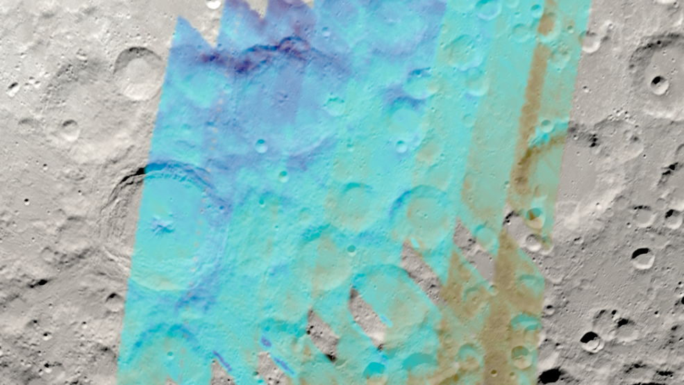
With clear, identifiable lunar features marked out by the water data, the study provides hints about how water may be moving across the Moon’s surface, particularly near its South Pole — an important area for space exploration.
Credits: NASA’s Goddard Space Flight Center Scientific Visualization Studio/Ernie Wright
The new map covers about one-quarter of the Earth-facing side of the lunar surface below 60 degrees latitude and extends to the Moon’s South Pole. Given the large region covered, the researchers could easily identify how water relates to surface features on the Moon, staying away from sunlight and favoring cold areas.
“When looking at the water data, we can actually see crater rims, we see the individual mountains, and we can even see differences between the day and night sides of the mountains, thanks to the higher concentration of water in these places,” said Bill Reach, director of the SOFIA Science Center at NASA’s Ames Research Center in California’s Silicon Valley and lead author on the study, which was presented at the 2023 Lunar and Planetary Science Conference.
In late 2024, NASA’s Volatiles Investigating Polar Exploration Rover (VIPER) will land in the region studied by SOFIA, atop Mons Mouton, to conduct the first resource mapping mission beyond Earth. The flat-topped lunar mountain will be a region of emphasis in the next paper from the team that led the current study of SOFIA data.
This current finding, along with two previous SOFIA results about the amount and distribution of water on the Moon’s sunlit surface, tracks a unique light signature of water. Other missions observing wide areas of the lunar surface have studied different wavelengths of light, which can’t distinguish water from similar molecules, such as hydroxyl. The Moon’s water is present in the soil and might be found as ice crystals, or as water molecules chemically bound to other materials.
Instead of determining the absolute quantity of water in the region, the researchers compared the data obtained around the Moon’s South Pole to a relatively dry reference region near the Moon’s equator to see how its abundance changes. The water was found in greater concentrations on the shadowed sides of craters and mountains, similar to the way skiers on Earth know the slopes receiving less direct sun retain snow longer. This suggests the Moon’s local geography plays an important role in the amount of water present.
As NASA prepares to send astronauts back to the Moon under Artemis, the agency has identified 13 candidate landing regions near the lunar South Pole. Through Artemis, NASA will land the first woman and the first person of color on the Moon, and lunar water could be a critical resource for establishing a long-term human presence.
“With this map of SOFIA data, and others to come, we are looking at how water is concentrated under different lunar environmental conditions,” said Casey Honniball, a visiting assistant research scientist and VIPER science team member at NASA’s Goddard Space Flight Center, in Greenbelt, Maryland, who was involved in the work. “This map will provide valuable information for the Artemis program on potential prospecting areas but also provides regional context for future science missions, like VIPER.”
In addition to the southern region for which the new map results were created, SOFIA observations of sites relevant to other missions are in the archive and now being analyzed. NASA Artemis-related missions will target both polar and non-polar regions, including Lunar Trailblazer, which will orbit the Moon to map its hydroxyl and water.
Where the Moon’s water may be coming from — whether it is ancient and exists inherently in the Moon’s minerals as a result of early volcanic processes on the Moon or is contemporary and delivered by asteroids, comets, or solar wind, and whether it is migrating along the Moon’s surface — is another important question left open by the SOFIA observations. VIPER will aim to better understand this distinction, which is important in determining if the water is widespread and deep within the surface, or only scattered at or near the surface.
It’s clear, however, that even at its lowest limit, the Moon contains much more water than we once believed.
“Our common knowledge from the Apollo era that the Moon is bone dry was wrong,” said Paul Lucey, a professor at the University of Hawaii at Mānoa and co-author on the paper. “We already know it’s wrong, but the question is by how much.”
SOFIA was a joint project of NASA and the German Space Agency at DLR. DLR provided the telescope, scheduled aircraft maintenance, and other support for the mission. NASA’s Ames Research Center in California’s Silicon Valley managed the SOFIA program, science, and mission operations in cooperation with the Universities Space Research Association, headquartered in Columbia, Maryland, and the German SOFIA Institute at the University of Stuttgart. The aircraft was maintained and operated by NASA’s Armstrong Flight Research Center Building 703, in Palmdale, California. SOFIA achieved full operational capability in 2014 and concluded its final science flight on Sept. 29, 2022.
For news media:
Members of the news media interested in covering this topic should reach out to the Ames newsroom.