

















Japan’s MTSAT-2 (also known as Himawari-7) collected these images of today’s annular solar eclipse from geostationary orbit. The satellite (similar to the United State’s GOES satellites), observed the moon’s shadow as it passed over Australia & the Pacific Ocean. The image sequence begins at 21:32 UTC, with an additional image each hour until 02:32 UTC. […]
ISS Daily Summary Report – 05/10/13
New Status: Channel 2B to Channel 2A Power Transfer: Due to the loss of cooling on the 2B channel, ground controllers successfully performed a seamless power channel handover. Channel 2A is now supplying power to the 2B loads with no impact to powered equipment. Channel 2B is isolated and dormant. USOS Extravehicular Activity (EVA) Preparations: Tomorrow Flight …
Witek’s World
Last year, when working with the NASA GPM team in the planning stages for the Iowa Flood Studies project, more affectionately known as IFloodS, I worried — a lot. 2012 was a year of historic drought in Iowa. IFloodS is all about studying and measuring precipitation. What if drought continued into 2013? In short, what […]
ISS Daily Summary Report – 05/09/13
New Status: This afternoon the crew noticed white flakes floating outside on the port side of the vehicle. At the same time ground teams noticed a drop in the 2B Photovoltaic Thermal Control System (PVTCS) ammonia pressure, indicating an external ammonia leak. The 2B PVTCS has had a known slow leak for several months, but …
ISS Daily Summary Report – 05/08/13
New Status: Node 3 Carbon Dioxide Removal Assembly (CDRA) Air Selector Valve (ASV) 102 Remove & Replace (R&R): On April 25 the Node 3 CDRA valve 102 failed to reach its commanded position. Over the following 24 hours the CDRA shut down 6 more times due to valve 102 not reaching position. Engineering teams reviewed the …
Spring Data Collection Features a Winter Mix
The big science highlight so far is that over May 2 through May 4, the GPM Ground Validation team finally collected a coordinated, co-scanned multi-radar frequency and dual-polarimetric dataset with the D3R and NPOL radars and we did it in one of the most complex multi-day precipitation events that we’ll measure in mid and high […]
ISS Daily Summary Report – 05/07/13
New Status: Robonaut Taskboard/Teleops: Following yesterday’s procedures review and camcorder setup, today Cassidy and Marshburn retrieved Robonaut and supporting hardware, installed Robonaut to a seat track and connected the cables for powered/commanded operations. Today and tomorrow will be the 3rd 2-day session of these activities. The Robonaut Tele-operation System is used to demonstrate the ability to …
NASA All Sky Fireball Network Captures Eta Aquarids
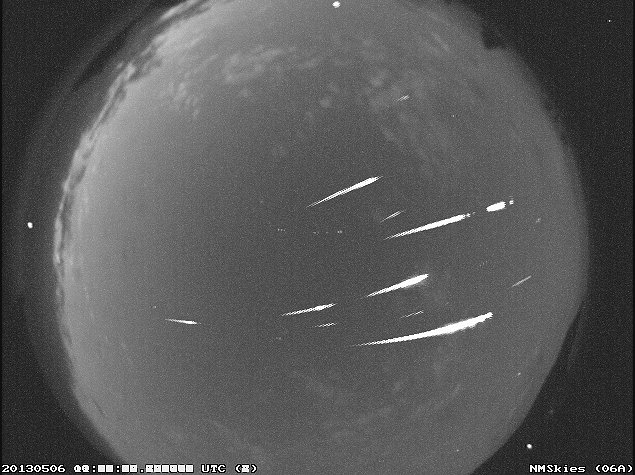
A composite image of 13 Eta Aquarid meteors from the NASA All Sky Fireball Network station in Mayhill, New Mexico the morning of May 6, 2013. Clouds seriously hampered our view of the ETAs this year. Observations reported to the International Meteor Organization indicate an outburst in the early hours of May 6th UTC.(Credit: All Sky …
First Observations of the 2013 Eta Aquarids
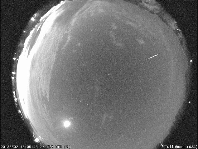
Despite interference from the moon and clouds (and rising sun!), this morning we snagged our first observations of the 2013 Eta Aquarids. Here’s an image of one from the all sky camera in Tullahoma, Tennessee. The Eta Aquarids peak in the pre-dawn hours on May 6 and are material from Halley’s comet. They zoom around …
ISS Daily Summary Report – 05/06/13
New Status: Spinal: Hadfield and Marshburn conducted their 3rd and final session of this experiment with Cassidy as operator and remote guidance from ground teams. Spinal Ultrasound uses ground and space-based studies to characterize spinal changes during and after spaceflight. Ground based pre- and post-flight Magnetic Resonance Imaging (MRI) and high fidelity ultrasound, combined with in-flight …