


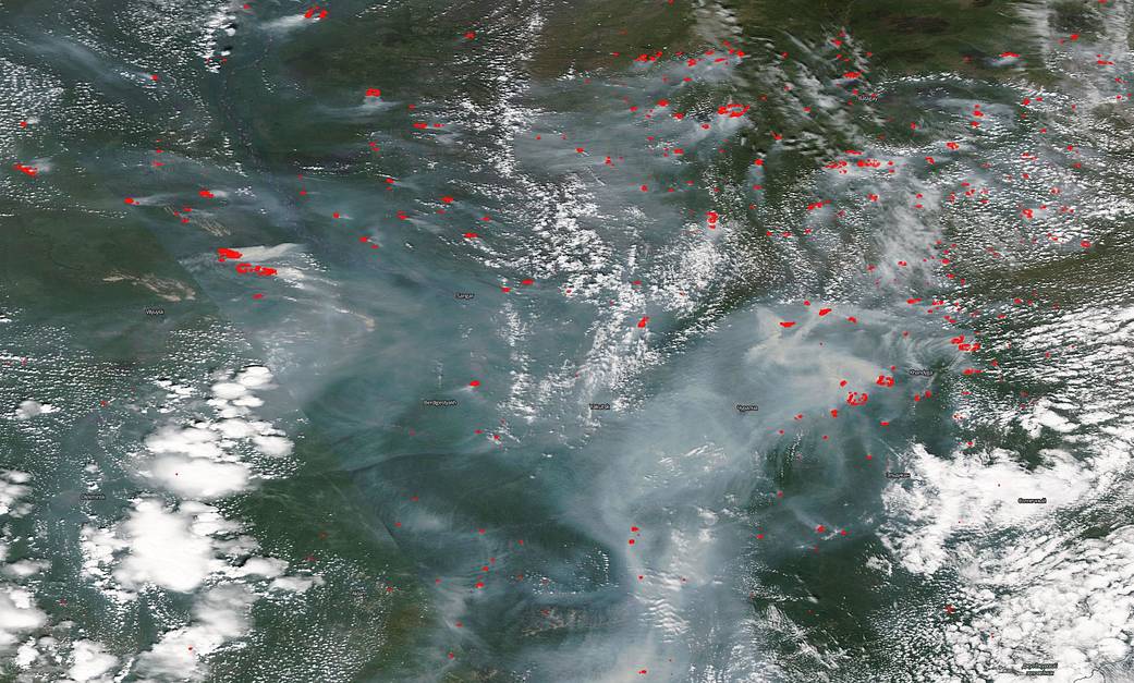
NASA’s Aqua satellite captured this image of Siberian fires criss-crossing the landscape and huge clouds of smoke obscuring large portions of the countryside. The Aqua satellite captured the image with its MODIS (Moderate Resolution Imaging Spectroradiometer) instrument on July 01, 2020. The fires, denoted by red dots on the image, cover a large portion of the Siberian wilderness as smoke pours off the fires, rising into the skies. The smoke will eventually rise into the upper atmosphere and catch a ride on the jet stream to other areas of the globe.
Siberian fires have been seasonal. However, NASA scientists are now reporting that, “Peat fires are notorious for their potential to over-winter smoldering underground only to reappear in early spring. The term for reappearing fires that are renewed in spring is ‘zombie fires’.” So perhaps they never did end, they just smoldered underground until the temperatures rose giving rise to the idea that the fires are now year-round, albeit sometimes dormant.
These fires also tend to be both large and smoky. Large because of the massive amount of physical area that the fires are able to spread to, much of it inaccessible, and smoky because much of the fuel for Siberian fires is taiga, peat bogs, and tundra all of which tend to smoke more than other types of fuels such as trees and grasses. All three also have higher concentrations of carbon which when burned are released into the atmosphere. Higher carbon emissions cause temperatures to rise, and this year Siberia saw a new temperature record of 100.4 degrees Fahrenheit (38 degre
Siberia is also inaccessible and very lightly populated so fires are allowed to burn unabated. This year (2020) the fires are reacting to historic heatwaves across the region. With the rise in heat, the fires will continue to break out more quickly and spread faster. The region is experiencing stronger winds which is helping the fires progress across the country. The Russia agency for aerial forest fire management, Aviales, is reporting that 3.4 million acres are burning in inaccessible areas. Less than 1.1 million acres were burning last week meaning that the number of acres burning has tripled in one week.
NASA’s satellite instruments are often the first to detect wildfires burning in remote regions, and the locations of new fires are sent directly to land managers worldwide within hours of the satellite overpass. Together, NASA instruments detect actively burning fires, track the transport of smoke from fires, provide information for fire management, and map the extent of changes to ecosystems, based on the extent and severity of burn scars. NASA has a fleet of Earth-observing instruments, many of which contribute to our understanding of fire in the Earth system. Satellites in orbit around the poles provide observations of the entire planet several times per day, whereas satellites in a geostationary orbit provide coarse-resolution imagery of fires, smoke and clouds every five to 15 minutes. For more information visit: https://www.nasa.gov/mission_pages/fires/main/missions/index.html
NASA’s Earth Observing System Data and Information System (EOSDIS) Worldview application provides the capability to interactively browse over 700 global, full-resolution satellite imagery layers and then download the underlying data. Many of the available imagery layers are updated within three hours of observation, essentially showing the entire Earth as it looks “right now.” Actively burning fires, detected by thermal bands, are shown as red points. Image Courtesy: NASA Worldview, Earth Observing System Data and Information System (EOSDIS). Caption: Lynn Jenner with information from Inciweb.