


![Request for Information – Potential [Placeholder for Prize]](https://assets.science.nasa.gov/dynamicimage/assets/science/psd/solar/2023/09/s/solarsystem_0.jpg?w=1024)


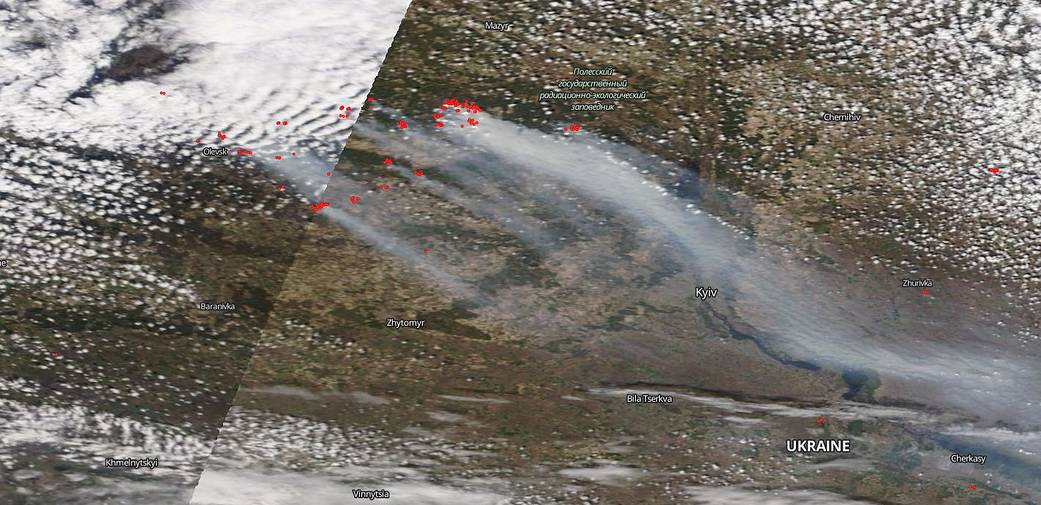
On April 17, 2020, NASA’s Terra satellite captured this image of new fires breaking out near the Chernobyl Nuclear Power Plant in Ukraine. On April 14, the fires that had broken out at the beginning of April were mostly extinguished, however smouldering sections still remained. On Thursday, April 16, new fires erupted and spread quickly due to high winds. Large, dark gray billowing clouds of smoke rise from the fires in this image and are seen traveling more than 757 km (470 miles). This area is the site of the Chernobyl nuclear accident that occurred on Saturday 26 April 1986 at the No. 4 nuclear reactor in the Chernobyl Nuclear Power Plant, near the city of Pripyat in the north of the Ukrainian SSR. Seasonal fires do break out around Chernobyl but it is estimated that the range of this fire from beginning to now has reached 50,000 acres which makes this wildfire the largest since the nuclear accident occurred.
NASA’s satellite instruments are often the first to detect wildfires burning in remote regions, and the locations of new fires are sent directly to land managers worldwide within hours of the satellite overpass. Together, NASA instruments detect actively burning fires, track the transport of smoke from fires, provide information for fire management, and map the extent of changes to ecosystems, based on the extent and severity of burn scars. NASA has a fleet of Earth-observing instruments, many of which contribute to our understanding of fire in the Earth system. Satellites in orbit around the poles provide observations of the entire planet several times per day, whereas satellites in a geostationary orbit provide coarse-resolution imagery of fires, smoke and clouds every five to 15 minutes. For more information visit: https://www.nasa.gov/mission_pages/fires/main/missions/index.html
NASA’s Earth Observing System Data and Information System (EOSDIS) Worldview application provides the capability to interactively browse over 700 global, full-resolution satellite imagery layers and then download the underlying data. Many of the available imagery layers are updated within three hours of observation, essentially showing the entire Earth as it looks “right now.” This satellite image was collected on April 17, 2020. Actively burning fires, detected by thermal bands, are shown as red points. Image Courtesy: NASA Worldview, Earth Observing System Data and Information System (EOSDIS). Caption: Lynn Jenner