


![Request for Information – Potential [Placeholder for Prize]](https://assets.science.nasa.gov/dynamicimage/assets/science/psd/solar/2023/09/s/solarsystem_0.jpg?w=1024)


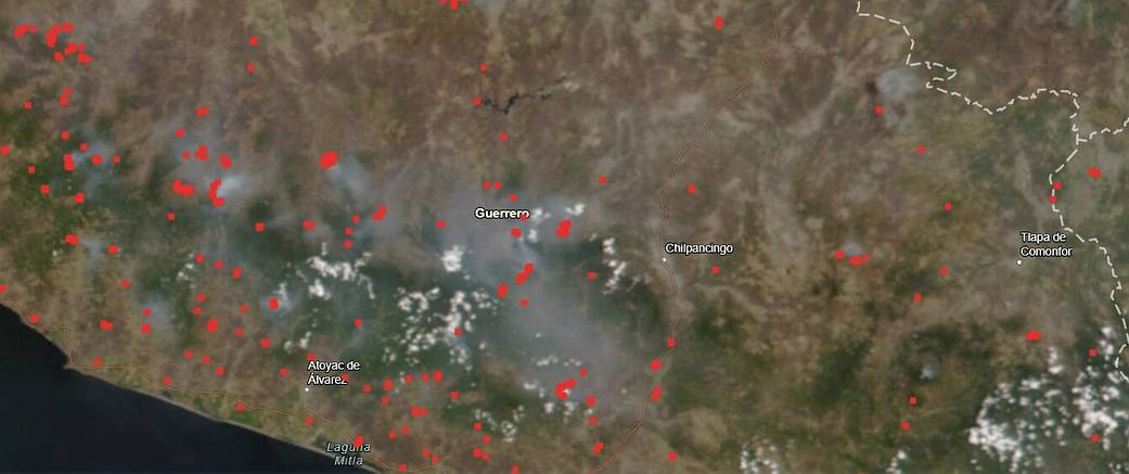
Fires that have been around Guerrero Mexico since at least the beginning of May are continuing to burn. Guerrero is a state on Mexico’s Pacific coast. According to the National Forestry Commission of the Government of Mexico, the fire situation for Mexico on May 25, 2020, is as follows: “At 11:00 am, 48 active forest fires are registered, whose affected vegetation is mostly pastures and bushes. There are 1,074 fighters working. The recommendation to the population not to use fire in forest areas continues, since the dry season is expected to be strong.” This image was captured on May 25, 2020 using a FIRMS Fire map. FIRMS Fire Map allows for interactively browsing the full archive of global active fire detections from MODIS and VIIRS. Near real-time fire data are available within approximately 3 hours of satellite overpass and imagery within 4-5 hours.
NASA’s satellite instruments are often the first to detect wildfires burning in remote regions, and the locations of new fires are sent directly to land managers worldwide within hours of the satellite overpass. Together, NASA instruments detect actively burning fires, track the transport of smoke from fires, provide information for fire management, and map the extent of changes to ecosystems, based on the extent and severity of burn scars. NASA has a fleet of Earth-observing instruments, many of which contribute to our understanding of fire in the Earth system. Satellites in orbit around the poles provide observations of the entire planet several times per day, whereas satellites in a geostationary orbit provide coarse-resolution imagery of fires, smoke and clouds every five to 15 minutes. For more information visit: https://www.nasa.gov/mission_pages/fires/main/missions/index.html
NASA’s Earth Observing System Data and Information System (EOSDIS) Worldview application provides the capability to interactively browse over 700 global, full-resolution satellite imagery layers and then download the underlying data. Many of the available imagery layers are updated within three hours of observation, essentially showing the entire Earth as it looks “right now.” Actively burning fires, detected by thermal bands, are shown as red points. Image Courtesy: NASA FIRMS – to view image on the FIRMS website: https://firms.modaps.eosdis.nasa.gov/map/#t:adv;d:2020-05-25;l:viirs=D,countries,viirs_crtc;@-99.5,17.5,9z. Caption: Lynn Jenner with information from the Comisión Nacional Forestal of Mexico.