


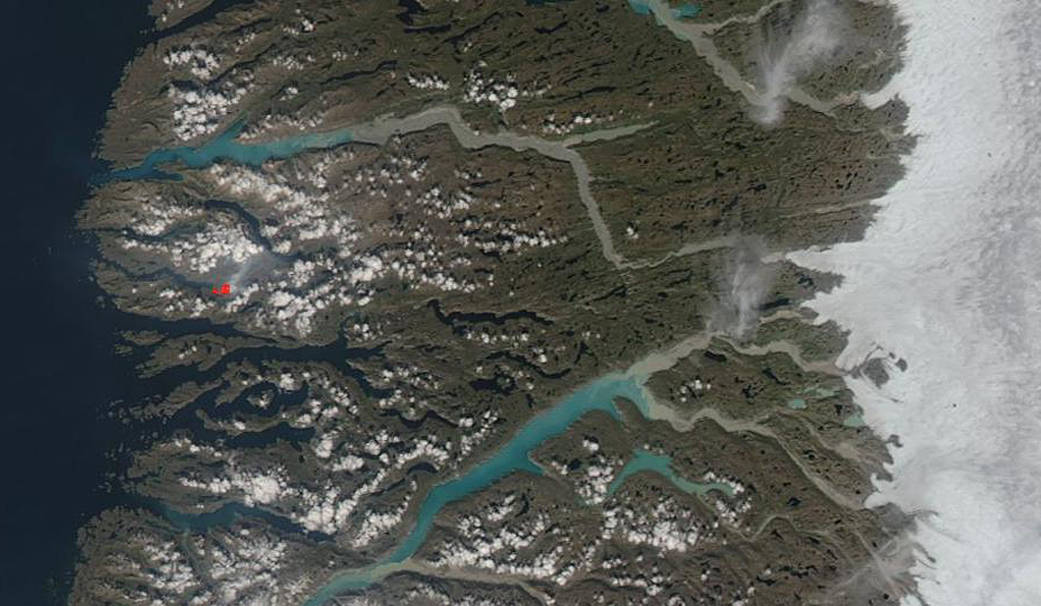
Greenland is an immense island and an autonomous Danish territory located between the North Atlantic and Arctic oceans. Much of its land surface is covered in ice. So it’s unusual when a fire breaks out on this northern island. In 2017 scientists were surprised by the fire that broke out. The 2017 fire burned in western Greenland, about 150 kilometers (90 miles) northeast of Sisimiut. Fire is not a usual feature in this stark, cold land. It’s not unheard of, but it is very rare. This year a fire was detected on July 10. According to the Earth Observatory, “This fire was short-lived in comparison to the 2017 blaze, which persisted for two weeks. In this case, firefighters extinguished the blaze by July 11, the day after it began.” Which makes this image, captured by the Aqua satellite, unprecedented. It is possible that the same fire from July 10 reignited or it could be that a new fire began shortly after the other fire was extinguished. The MODIS instrument aboard NASA’s Aqua satellite picked up a hot spot as seen in the center left side of the image in red. Red areas indicate heat. The Greenlandic Broadcasting Corporation reports this: “A large natural fire is currently underway at the bottom of a fjord north of Sisimiut. The fire emits a lot of smoke, and the smoke makes it difficult for the firefighters to extinguish the flames. The fire has started at the bottom of the Kangerluarsuk Tulleq fjord, but the smoke is close to several places on the road between Sisimiut and Kangerlussuaq. At the moment, tourists are walking on the route, and it can be dangerous to inhale the smoke, says Sisimiut’s emergency response. Emergency manager Ole Kreutzmann informs KNR that the firefighters have trouble getting close enough to the nature fire to turn it off – precisely because there is so much smoke. The fire station in Sisimiut is here this morning evaluating what they can do to kill the flames.” Climate change continues to give scientists puzzling and unsettling new side effects to study.
NASA’s Earth Observing System Data and Information System (EOSDIS) Worldview application provides the capability to interactively browse over 700 global, full-resolution satellite imagery layers and then download the underlying data. Many of the available imagery layers are updated within three hours of observation, essentially showing the entire Earth as it looks “right now.” This Aqua satellite image was collected on July 14, 2019. Image Courtesy: NASA Worldview, Earth Observing System Data and Information System (EOSDIS). Caption: Lynn Jenner with information from Earth Observatory and the Greenlandic Broadcasting System