


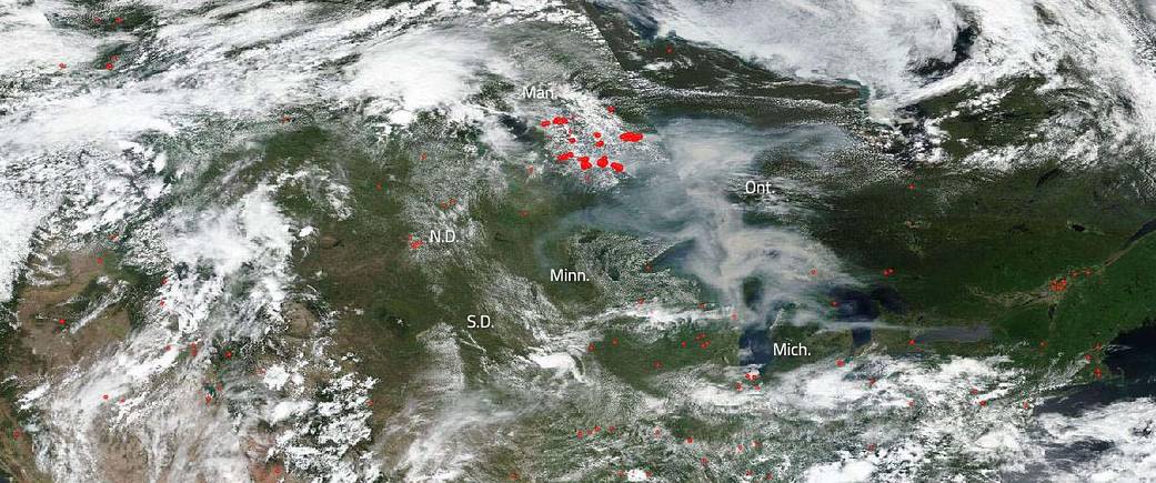
Canada has been battling a very active and destructive fire season on multiple fronts this year. A warming climate, very dry environment, and more extreme weather including severe thunderstorms has led to massive wildfires throughout the country. Two of the provinces hardest hit by these fires are Ontario and Manitoba. On July 7, 2019, the Suomi NPP satellite using its VIIRS (Visible Infrared Imaging Radiometer Suite) instrument captured this image of the fires ongoing in the region. Also visible in this image is the massive amount of smoke pouring off these fires and moving southeast into other parts of Ontario, over the Great Lakes, and into Michigan. Small amounts are also seen drifting into Minnesota. The smoke will continue to drift southward as it’s carried on the jet stream. Actively burning areas, detected by VIIRS’s thermal bands, are outlined in red. Suomi NPP is managed by NASA and NOAA.

NASA’s Earth Observing System Data and Information System (EOSDIS) Worldview application provides the capability to interactively browse over 700 global, full-resolution satellite imagery layers and then download the underlying data. Many of the available imagery layers are updated within three hours of observation, essentially showing the entire Earth as it looks “right now.” Image Courtesy: NASA Worldview, Earth Observing System Data and Information System (EOSDIS). Caption: Lynn Jenner