


![Request for Information – Potential [Placeholder for Prize]](https://assets.science.nasa.gov/dynamicimage/assets/science/psd/solar/2023/09/s/solarsystem_0.jpg?w=1024)


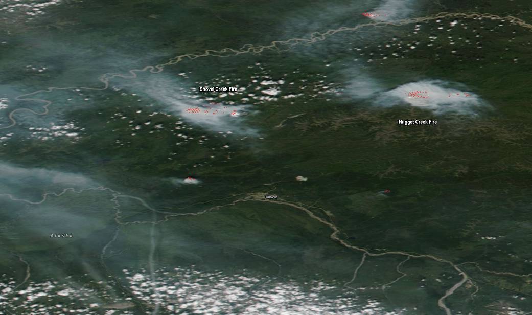
Two Alaska fires are generating a good amount of smoke captured in an image from NASA’s Terra satellite. The Shovel Creek and Nugget Creek fires are located northwest and northeast of Fairbanks, respectively.
On June 27, 2019, the Moderate Resolution Imaging Spectroradiometer or MODIS instrument aboard NASA’s Terra satellite provided a visible image of east central Alaska, which is where Fairbanks is located. The visible image showed two large areas of light brown smoke, generated from each fire. MODIS also detects heat signatures, and those hot spots are indicative of fires (which appear as red spots on the image).
On Thursday, June 27, the National Weather Service office in Fairbanks included “areas of smoke” in their forecast for Thursday and Friday, June 28.
Both Shovel Creek and Nugget Creek fires were caused by lightning strikes and both fires are being managed by the Alaska Incident Management Team (AIMT).
The Shovel Creek Fire
The Shovel Creek Fire was started by lightning on June 21 and is located 3 miles north of Murphy Dome, about 20 miles northwest of Fairbanks. As of June 27, 2019, the fire covered 1,622 Acres.
The AIMT noted, “Depending on weather conditions, smoke from this fire may drift into the Fairbanks and surrounding areas in the coming weeks. AIMT noted that the primary fuel is thick black/white spruce mixed forest on the slopes in the Shovel Creek drainage. At the top of the ridge, this fuel transitions to open tundra/brush fuel types.
Residents in the area are asked to avoid the Murphy Dome area due to the firefighting activity and the potential for interfering with fire personnel. A Temporary Flight Restriction is in place in the air space over the fire.
For more information about the Shovel Creek Fire, visit: https://inciweb.nwcg.gov/incident/6400/
The Nugget Creek Fire
Like the other fire, Nugget Creek Fire started on June 21, 2019 by lightning. The fire is located approximately 35 miles east of Fairbanks in the area of 30 Mile Chena Hot Springs Road in the Chena River State Recreation Area. As of June 27, 2019, the fire covered 665 acres.
According to Inciweb, the incident information System, “The fire is predominately burning in Alaska forest fuels consisting of mixed spruce and hardwoods birch/aspen. Fire scars exist to the west and east which will potentially limit the spread of the fire to in those directions if the fire reaches those areas.”
For more information about the Nugget Creek Fire, visit: https://inciweb.nwcg.gov/incident/6401/.
Rob Gutro, with information from Inciweb and the National Weather Service in Fairbanks, Alaska
Image Credit: NASA Worldview, Earth Observing System Data and Information System (EOSDIS)