


Fire destroys and decimates. It takes out almost everything in its path. In the wake of a fire, a burn scar appears which takes a long time to heal. The mountains of San Bernardino County in Southern California were in a healing pattern for ten years after the Paradise and Cedar wildfires burned hundreds of thousands of acres north and east of San Diego in 2003, according to Weather.com. The scar can also portend other negative events which can happen in the aftermath of a major fire. Devoid of vegetation, nothing remains to hold the land in place when rainfall comes and mudslides often occur. Rainfall and mudslides can be deadly, killing those in its wake. But these events also bring life back into the remaining landscape, allowing new plants to grown in the scarred area. These plants will eventually grow to be the bushes and trees that will hold the earth in place.
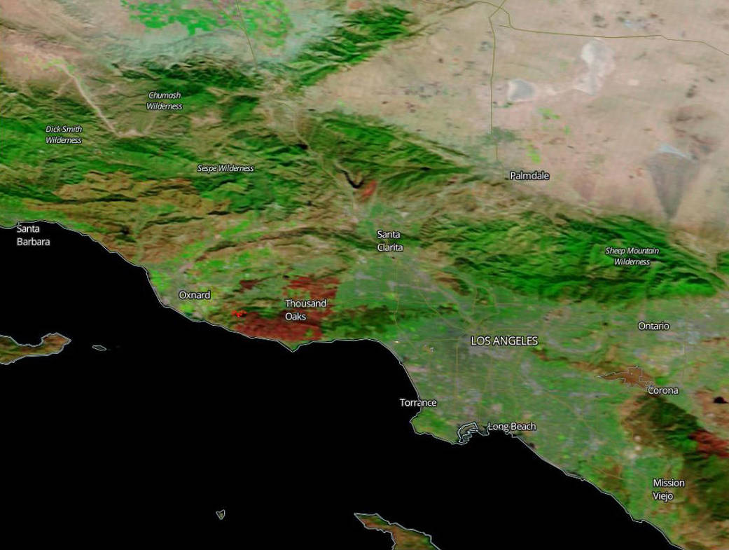
So too, the Woolsey Fire which began on November 08, 2018, the same day the Camp Fire began to the north, leaves behind a huge brownish-red scar on the land that burned in Ventura County, California. Residents will need to be vigilant in the wake of this fire for those mudslides which can occur. It is hard to conceive of the scar healing when the fire still remains uncontained. On CAFire, the size of the fire is listed as 98,362 acres. It is 57 percent contained and there have been two fatalities attributed to the fire. There have been 435 structures destroyed and 57,000 residents are in danger. Already 200,000 residents have been evacuated and the fire has marched to the Pacific Ocean spreading 15 miles south from Simi Valley to Malibu.
Weak southwesterly/onshore winds are expected to develop. With this wind shift, temperatures will be a bit cooler this afternoon and minimum relative humidity will be a bit higher. This will allow firefighters to build and improve fire lines in order to minimize fire growth as well as support the existing containment of the fire.
This false-color image was taken by the Terra satellite using the corrected reflectance bands on the MODIS instrument to highlight the scarred areas on November 14, 2018. NASA’s Earth Observing System Data and Information System (EOSDIS) Worldview application provides the capability to interactively browse over 700 global, full-resolution satellite imagery layers and then download the underlying data. Many of the available imagery layers are updated within three hours of observation, essentially showing the entire Earth as it looks “right now.” Actively burning fires, detected by thermal bands, are shown as red points. Image Courtesy: NASA Worldview, Earth Observing System Data and Information System (EOSDIS). Caption: Lynn Jenner with information from CAFire and Weather.com