


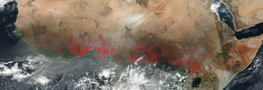
The VIIRS instrument (Visible Infrared Imaging Radiometer Suite) on NASA’s Suomi NPP satellite collected this natural-color image which detected dozens of fires burning in Central Africa on January 04, 2017. The location, widespread nature, and number of fires suggest that these fires were deliberately set to manage land. Farmers often use fire to return nutrients to the soil and to clear the ground of unwanted plants. While fire helps enhance crops and grasses for pasture, the fires also produce smoke that degrades air quality. Each hot spot, which appears as a red mark, is an area where the thermal detectors on the VIIRS instrument recognized temperatures higher than background. When accompanied by plumes of smoke, as in this image, such hot spots are diagnostic for fire. Actively burning areas, detected by VIIRS’s thermal bands, are outlined in red.
So too in this image are dust plumes radiating down from the Sahara Desert. The Sahara Desert in Africa covers an area of 3.6 million square miles (9.4 million square kilometers), and covers most of North Africa. The desert extends into large sections of Algeria, Chad, Egypt, Libya, Mali, Mauritania, Morocco, Niger, Western Sahara, Sudan and Tunisia. In the image, plumes of dust from Chad and Niger were streaming to the southwest.
NASA image courtesy Jeff Schmaltz LANCE/EOSDIS MODIS Rapid Response Team, GSFC. Caption by Lynn Jenner
Suomi NPP is managed by NASA and NOAA.