


May 2021 issue of Ames' newsletter, the Astrogram

NASA Lands in Oakland!
Chabot Space & Science Center Partners With NASA in the East Bay
by Darryl Waller
A new partnership between NASA’s Ames Research Center in California’s Silicon Valley and Chabot Space & Science Center in Oakland, California, is now underway. Anchoring the partnership, a new visitor center for Ames will provide an immersive, dynamic STEAM environment called “The NASA Experience,” opening at Chabot in November 2021.
Under the terms of a five-year Space Act Agreement, the organizations are beginning a long-term collaboration to create accessible STEAM, or science, technology, engineering, art, and math, community engagement and education opportunities in Oakland and beyond.
“We are delighted to have this opportunity to bring a deeper NASA experience into our surrounding communities,” said Eugene Tu, director of Ames. “It’s one of NASA’s founding functions to share our work as widely as possible, and this partnership for a new visitor’s center will allow us to reach more broadly than we’d ever be able to do with our existing resources and location in the South Bay.”
Under the formal agreement, NASA and Chabot have identified three main areas for immediate collaboration that leverage the strengths of NASA’s research and Chabot’s long-standing programs.
First, The NASA Experience creates an immersive, dynamic, STEAM learning environment that puts the visitor into the role of a NASA researcher. Hands-on STEAM studios highlight the current science at NASA through interactive challenges, models, artifacts, and more. The visitor center brings to life the thrilling, challenging, and inspiring process of scientific discovery by showcasing the real stories and people at NASA’s Ames Research Center.
“We are so excited to share the fascinating science, extraordinary people and groundbreaking research of NASA’s Ames Research Center right here in Oakland,” said Adam Tobin, executive director at Chabot Space & Science Center. “Bringing together NASA Ames’ long legacy of innovation and Chabot’s 137-year history in STEM education creates a powerful opportunity to inspire the next generation of future scientists, engineers and astronomers.”
Leading up to the November opening, Chabot and Ames will provide engaging virtual programs hosted on Chabot Space & Science Center’s Facebook and YouTube platforms to offer participants a closer look at NASA’s mission.
Second, the two groups will create an interconnected network of STEAM education experiences throughout the city that deepens Chabot’s existing “Learning Everywhere” initiative. Building on existing connections with Oakland’s schools, libraries, and local organizations, this partnership will create programs that engage learners in current NASA research.
Third, the partnership will create tangible STEAM career pathways by developing explicit connections between NASA’s career opportunities and Chabot’s youth development programs. NASA will provide speakers, fieldtrips, and independent study on the missions and technology associated with work happening at Ames in collaboration with Chabot’s Galaxy Explorers program, first established in 2000.
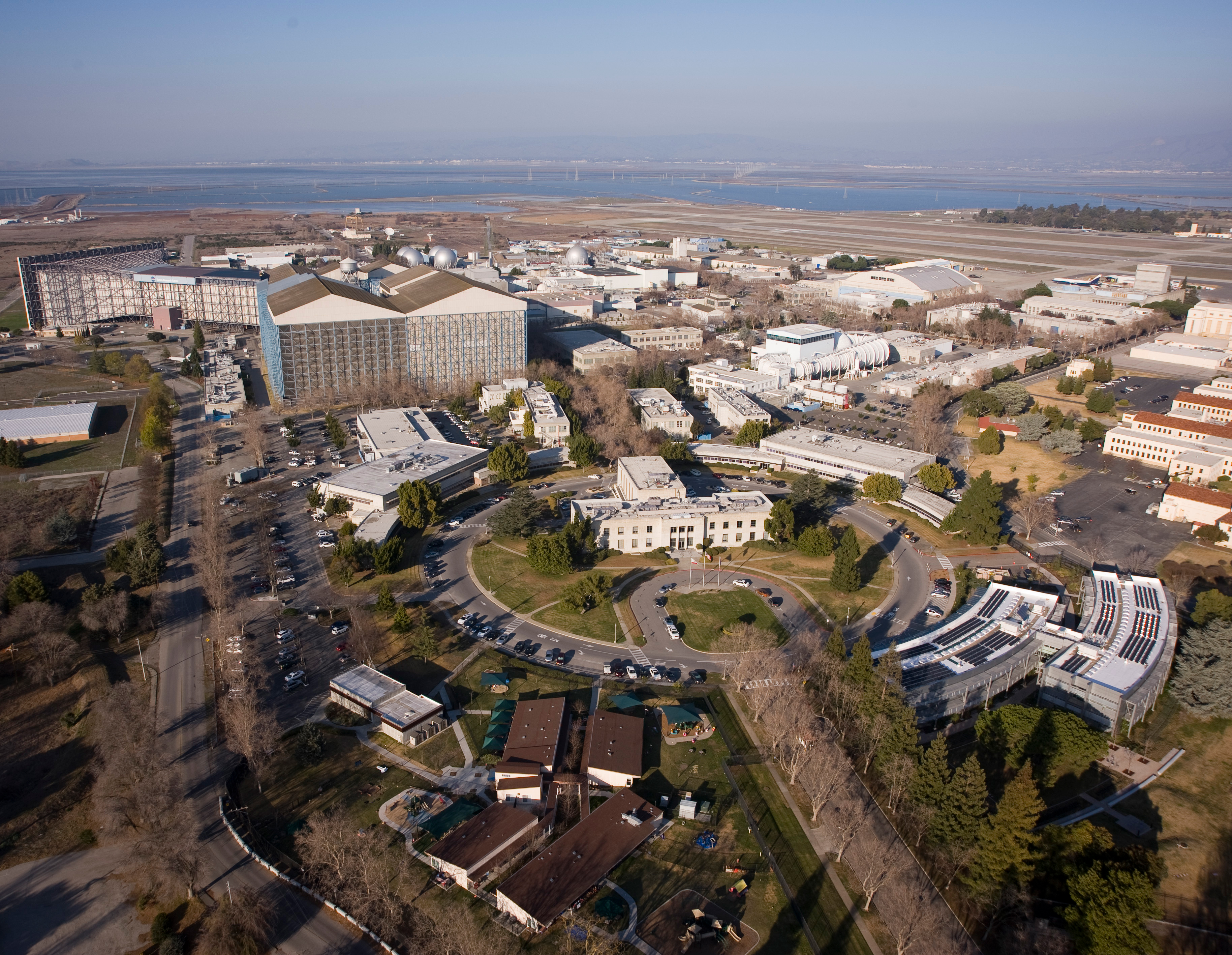
NASA’s Ames Research Center, one of 10 NASA field centers across the country, is located in the heart of California’s Silicon Valley. Since 1939, Ames has led NASA in conducting world-class research and development in aeronautics, exploration technology, and science aligned with the center’s core capabilities.
Life Goals: NASA Software Unlocks Martian Rover Productivity
by Rachel Hoover
Productivity pundits know lots of tricks to make the most of your day, so you can schedule enough time for important tasks while guarding against overload. Planning a day of work for a Martian rover puts a lot of the same strategies into practice.
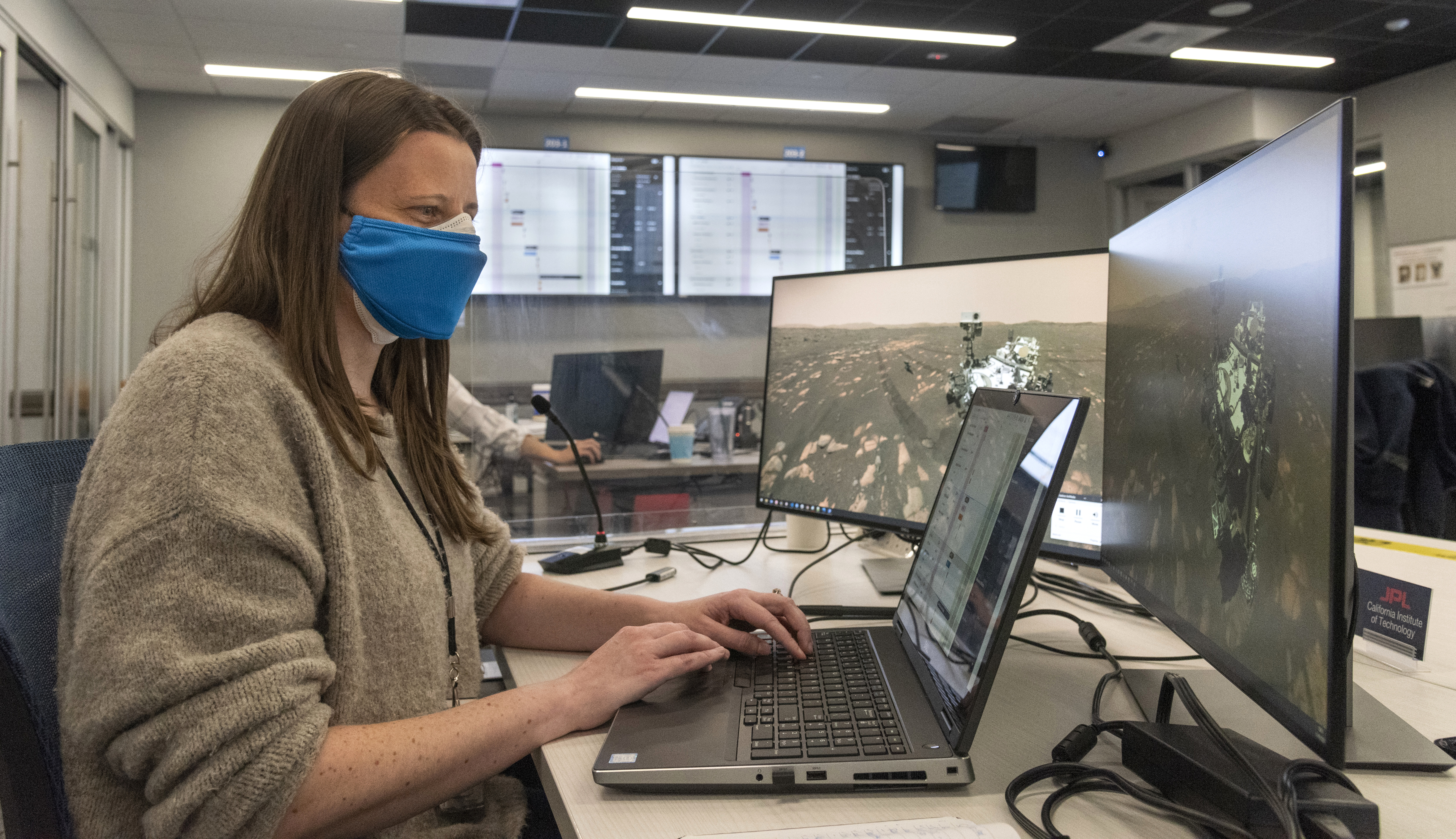
When the Mars 2020 Perseverance’s driving and science activities begin, dozens of mission personnel will start each planning session with a massive trove of new and exciting data and images from Mars. They have limited time to make sense of the data and create a plan for what the rover will do during the next Martian day. The pressure is on, because in order for the rover to download the plans, they need to send them before the next satellite passes above Perseverance.
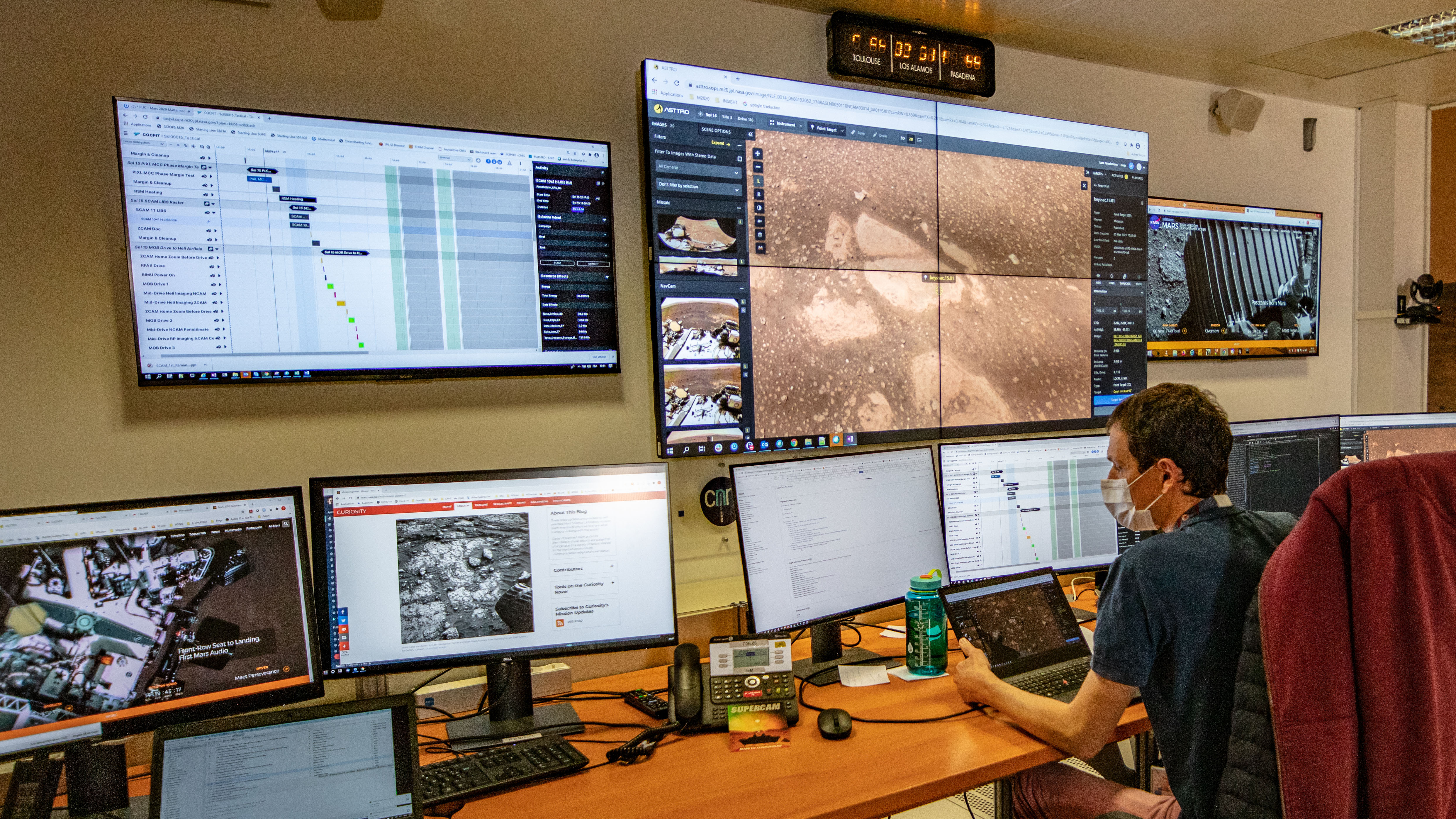
The team in charge of coordinating rover activities have a new, NASA-made, web-based application to optimize the planning process and cut precious hours off the time needed to develop next steps. The Component-based Campaign Planning, Implementation, and Tactical software tool, or COCPIT, enables scientists and engineers to lay out all of the rover’s surface activities – from drives to drills – while ensuring the rover has enough time, battery power, data bandwidth, and storage memory, to pull it all off. If a team member were to inadvertently schedule too many activities, cause a conflict in the plan, or overload power or data, COCPIT would flag it and alert rover planners. COCPIT is the first NASA planetary mission planning and scheduling tool to be web-based, which means the international team of scientists can collaboratively plan off-world activities from anywhere on ours; a critical asset in a time of COVID-19 precautions and remote work.
With years of complex activities ahead, involving an assortment of scientific instruments aboard Perseverance, COCPIT will plug into a suite of the robot’s other software tools and help achieve mission success. COCPIT is part of the next generation of planning and scheduling software tools developed by NASA’s Jet Propulsion Laboratory in Southern California in partnership with NASA’s Ames Research Center in California’s Silicon Valley. COCPIT is based off Playbook, a web-based software tool built by the Scheduling and Planning Interfaces for Exploration Team from the Human-Computer Interaction Group at Ames. The team has worked on mission planning and scheduling tools for four other Mars missions and the International Space Station. The team’s work with COCPIT and Playbook is paving the way for future software that supports human and robotic exploration of the Moon, Mars, and beyond.
For more information about Ames’ contributions to the Mars 2020 mission, visit: https://www.nasa.gov/ames/mars2020
What is Scalable Traffic Management for Emergency Response Operations?
by Abigail Tabor
For faster, smarter, safer emergency response operations, the STEReO project is combining NASA technologies with partnerships to build a system that’s greater than the sum of its parts.
When a natural disaster occurs, an impressive number of participants are often needed to help with the response. Consider just the number of different aircraft that might be involved in fighting a wildfire: tankers releasing fire retardant, lead planes to guide them, helicopters dropping off field crews, aircraft from which smokejumpers arrive on the scene… And that’s to say nothing of the activity taking place on the ground. Responding to an emergency like this – or a hurricane or search and rescue effort, to name a few – requires extensive collaboration among a host of groups that, right now, is coordinated manually under challenging conditions. This makes communication difficult.
New technologies have great potential to assist emergency responders, but they also bring new challenges. For instance, unmanned aircraft systems, commonly called UAS or drones, could make firefighters’ interventions faster, more targeted and better able to adapt to changing environments. However, these aircraft also demand special air traffic management, onboard tools to let them operate independently and safely, and expanded communications to keep everyone aware of what’s happening in the sky and on the ground.
Working to tackle these challenges and more is the Scalable Traffic Management for Emergency Response Operations project, or STEReO, led by NASA’s Ames Research Center in California’s Silicon Valley. By building on NASA technologies and expertise and bringing together solutions from multiple agencies involved in disaster response, STEReO aims to make an impact greater than any solution could have on its own. The work, which is a collaboration between Ames and two other NASA centers – Langley Research Center in Hampton, Virginia, and Glenn Research Center in Cleveland, Ohio – is a concept study under NASA’s Convergent Aeronautics Solutions initiative. The results of the CAS study, designed to determine STEReO’s feasibility, will be used to determine whether and how NASA will pursue further development.
STEReO’s Ecosystem for Emergency Response
STEReO envisions a new ecosystem for emergency response that has three broad goals: reduce response times, scale up the role of aircraft and provide operations that can adapt to rapidly changing conditions during a disaster. To demonstrate how its tools and concepts can achieve these goals in different emergency scenarios, STEReO will conduct a live flight demonstration of a wildfire event and a virtual simulation of a hurricane response.
In both cases, they will build on NASA expertise in diverse areas, including air traffic management, human factors research and autonomous technology development. This background, along with input from collaborators – STEReO’s partners range from federal agencies to city and state fire departments, utilities, and private companies – lets the team explore specific concepts like:
- Applying NASA’s Unmanned Aircraft Systems Traffic Management System, or UTM, to public safety uses, coordinating use of the airspace for both crewed and uncrewed aircraft operations
- Collaborative tools to take remote sensing information, such as from sensors on aircraft able to find gas leaks after an earthquake, and distribute a common picture of mission operations
- Communication networks to make the system more resilient to challenging operational environments
- Technologies for more autonomous UAS flight to ensure those operations are both safe and responsive to dynamic situations.
STEReO’s approach will bring increased awareness for all partners responding to an emergency, which could allow for earlier detection of problems and rapid decision making. The full package of STEReO’s emergency response ecosystem could also be scaled to the size and complexity of the specific environment, operations and objectives.
2020 Wildfire Fighting Training
In June 2020, STEReO team members attended a training activity for wildland firefighting, learning firsthand about a key role in this type of disaster response: the air tactical group supervisor, who acts as an airborne air traffic controller for all those planes and helicopters that help fight fires. Hosted by the California Department of Forestry and Fire Protection, this was a significant opportunity for the project to assess the current state of operations and understand components needed for their own flight demonstration. The experience revealed new potential collaborations where NASA know-how in air traffic management, UAS autonomy, UTM, and human factors can help these emergency responders do their jobs more effectively and safely.
2021 STEReO Testing with Firefighting Partners
Two events happening in early 2021 are letting the STEReO team test their technologies for communication and coordination in emergency response, working in valuable, hands-on settings with emergency responders.
In the hills east of Phoenix, the team joined the U.S. Forest Service, or USFS, for their annual training academy for aerial supervisors, from Feb. 22 to March 4. While USFS aircraft practiced maneuvers overhead, STEReO tested their tools on the ground. The prototype system collected live, publicly available position data from the USFS planes, and displayed that information on an aerial map hosted on a tablet. Meanwhile, STEReO “flew” simulated UAS operations included on the same map, feeding flight information, such as the positions of the virtual drones and the spaces in which they would operate, into the system.
The result was a first look at how a common operating picture that brings together disparate data sets can improve the awareness of USFS personnel. STEReO’s prototype system included a portable, rather than a cloud-based, UAS service supplier (a software system for coordinating UAS sharing the airspace) that could be used through an ad-hoc wifi network. Both elements are critical for emergency response teams acting in remote areas, for instance, where access to networks and support systems can be scarce. Participants could connect via their own digital device and see the whole picture of firefighting aircraft come together on a common map. The exercise let the Forest Service firefighters test out adding STEReO’s elements to their operations and to give essential user feedback.
From April 26 to May 7, STEReO heads to Redding, California, to work with both the California Department of Forestry and Fire Protection, or CAL FIRE, and the USFS. This wildfire flight demonstration is expected to include NASA drones flying in coordination with firefighting aircraft, putting STEReO’s systems through their paces in an even more realistic context.
Milestones:
- STEReO Stakeholder Workshop (Feb. 11-13, 2020)
- Firefighting field work: Air Tactical Group Supervisor Training (June 2020)
- Firefighting field work: U.S. Forest Service National Aerial Supervision Training Academy (Feb. 22-March 4, 2021)
- Airborne assessment of vehicle autonomy work with concurrent operations of NASA piloted and UAS aircraft (April 2021, tentative)
- Airborne assessment of vehicle autonomy work with concurrent operations of two NASA UAS vehicles (April 2021, tentative)
- Wildfire flight demonstration (April 26-May 7, 2021)
Collaborators:
NASA’s STEReO team is working with government and industry partners, including the U.S. Forest Service, the Federal Aviation Administration, the California Department of Forestry and Fire Protection, and Avision Inc.
STEReO is an execution activity of NASA’s Convergent Aeronautics Solutions project under the Transformative Aeronautics Concepts Program funded through the Aeronautics Research Mission Directorate.
From Sea to Space, NASA in Silicon Valley Works for Our Changing Earth
by Rachel Hoover
NASA is working beneath the sea, in Earth’s skies, and from orbit for the benefit of our planet. At NASA’s Ames Research Center in California’s Silicon Valley, our researchers and technologies help face the challenges of climate change that impact our lives: we are all #ConnectedByEarth.
1. One Year of Mapping the World’s Coral with NeMO-Net

A year ago, NASA launched the game NeMO-Net to help map the world’s coral. The game uses imagery captured using high-tech fluid lensing cameras able to capture detailed footage through the distortions of the water’s surface, and teaches players how to identify different kinds of coral. Since the game’s launch, players have completed over 75,000 detailed 3D coral classifications. All that data are now being used to build a global map of coral that will help scientists understand this unique life form like never before. Recent advances in fluid lensing imaging technology also will allow not just coral, but sea life to be captured in 3D from farther above the waves. The NeMO-Net app is now available for download on Mac, iOS, and Android.
2. New Technologies Could Help Face Climate-related Disasters
The strongest hurricanes are getting even stronger as ocean temperatures increase, and warming is increasing forest fire area and the length of the fire season in the Western U.S. A NASA project, Scalable Traffic Management for Emergency Response Operations, or STEReO, is developing a system to help emergency responders meet the challenge. STEReO aims to coordinate uncrewed and piloted aircraft responding to a disaster, track personnel on the ground, integrate measurements taken from the air, and bring it all together so participants can see the full operating picture on screen. A standalone system, it works without high-speed internet access, which could be lacking in a remote area struck by wildfire or a city following an earthquake or major storm.
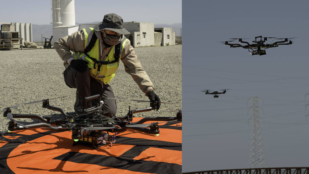
STEReO is a concept study building on NASA’s expertise in traffic management for unmanned aircraft systems, or drones. Right now, the team is putting its software tools and vehicles to the test with flights at NASA’s Ames Research Center in California’s Silicon Valley, where the project is led. In the picture to the left, NASA drone operator Zach Roberts completes a pre-flight check of a vehicle during testing on April 8, 2021. On the right, two drones are pictured in flight during the same tests.
Next, the team will participate in a flight demonstration with collaborators at NASA’s Glenn Research Center in Cleveland and NASA’s Langley Research Center in Hampton, Virginia, as well as STEReO’s wildfire-fighting partners at the U.S. Forest Service and the California Department of Forestry and Fire Protection.
3. Remote Sensing for Indigenous Communities
NASA has offered in-person workshops on remote sensing to tribal communities for several years. These workshops help build the capacity of tribes to use satellite Earth observations for natural and cultural resource management. In 2020, for the first time this program went virtual, hosting a training series in collaboration with the United Tribes Technical College in Bismarck, North Dakota on Remote Sensing for Tribal Lands. This webinar series included lectures, hands-on exercises, and is freely accessible to all.
The curriculum over the course covered a range of topics, from online remote sensing webtools to how to conduct land cover classifications. Each lecture included interactive exercises, using commercial and open source Geographic Information System, or GIS, software. Each week, participants gained practical and applicable skills in conducting Earth science with satellite imagery, had these practices contextualized with an Indigenous mindset, and were able to engage with NASA scientists to have their questions and concerns addressed.
By taking this intentional approach to delivering these educational resources, tribal communities and NASA can continue to expand on the frameworks already in place to fuse these approaches with Indigenous Knowledge.
4. Climate Action: Changing Course
Like efforts to address challenges posed by climate change, controllers and pilots must react to potential problems – bad weather or congested traffic – and change course. During last year’s flight tests on Boeing’s ecoDemonstrator programusing a 787-10 Dreamliner, NASA engineers tested a new air traffic management communications and decision-making software that can solve these complex problems faster and more efficiently than most humans. The Tailored Arrival Manager, or TAM, developed at NASA’s Ames Research Center in California’s Silicon Valley, calculates and then sends revised fuel-efficient courses to the cockpit for an airplane to follow using automatic flight control. Using TAM during experimental flights allowed engineers to take their ideas out of the lab and into the real world to make advances toward increasingly autonomous operations, while still being safe. Tools such as TAM are designed to make air traffic management more efficient to save fuel, reduce emissions and noise, and increase schedule reliability so passengers travel as safely and trouble-free as possible. NASA has participated with Boeing on its ecoDemonstrator program nearly every year since 2013. For this test, Ames collaborated with Boeing and the FAA’s William J. Hughes Technical Center.
On a Changing Planet, NASA Goes Green
by Emma Edmond, GSFC
NASA is responsible for collecting much of the data that people use to explain humanity’s environmental impact on Earth, from documenting climate change and its impacts on ice, sea level and weather patterns, to monitoring the health of forests and the movement of freshwater.
But NASA doesn’t just report the data. It also acts on it.
NASA facilities across the United States are each working toward becoming more sustainable workplaces. Across 47 million square feet and 5,000 buildings, NASA works to fulfill its mission of revealing the unknown while lessening its demand on the planet’s resources.
“NASA is a scientific leader, globally and nationally,” said Denise Thaller, director of NASA’s Environmental Management Division. “We embody that focus on the stewardship of the Earth, so we need to lead by example. We need to evaluate everything we do and make sure we’re reducing our impacts on the Earth while we study the Earth.”
Each year, the agency reports its progress in several key sustainability efforts.
Energy Efficiency
NASA’s energy intensity continued its downward trend in fiscal year 2019 (Oct. 1, 2018, through Sept. 30, 2019), the most recent year with externally published data available. Energy intensity refers to the amount of energy used to enable NASA’s mission — using less energy reduces energy intensity. Intensity can be reduced through a number of methods, such as installing LED lighting upgrades, which was completed in 2019 at NASA’s Goddard Space Flight Center in Greenbelt, Maryland, and Stennis Space Center in Stennis, Mississippi. These projects and others are projected to save 51 billion British thermal units (Btu) annually; that’s enough energy to power more than 1,400 single-family homes.
NASA has made significant progress on reducing water intensity too, a similar metric measuring of how much potable water is used to accomplish NASA’s mission.
Renewable energy made up just over 13% of NASA’s total electricity use in fiscal year 2019. Much of the percentage stemmed from purchasing Renewable Energy Certificates, or credits that represent a certain amount of renewable energy that is produced elsewhere. In addition, on-site renewable energy continues to increase. For example, as part of 58 renewable energy projects across 10 centers, NASA’s Kennedy Space Center in Florida and Marshall Space Flight Center in Huntsville, Alabama, installed rooftop solar panels in fiscal year 2019, adding to the other 56 on-site renewable energy projects NASA has implemented across 15 centers.
NASA also kicked off three long-term initiatives meant to reduce energy consumption and cost. First, NASA initiated an agency-wide campaign to increase sustainability awareness among employees. Second, the agency began piloting the Department of Energy 50001 Ready program, which requires NASA to continually improve energy management with quantifiable results. Third, NASA has identified significant energy users among the approximately 40% of its facilities that aren’t currently included within federal energy reduction goals because of their unique mission applications. These users include facilities like wind tunnels, and NASA has begun prioritizing efficiency investments to improve their sustainable infrastructure.
Infrastructure
“Our aging infrastructure costs a lot to maintain,” Thaller said. “One of the strategies is to renew by replacement. You have the opportunity to reduce your footprint not only by building a more sustainable building, but by building in energy efficiency, water efficiency, and how you optimize your square footage.”
Almost 20% of NASA buildings are considered sustainable, and the agency’s goal was to reach 25% in fiscal year 2020.
All new NASA facilities must meet specific federal requirements for sustainability, and receive at least a Leadership in Energy and Environmental Design Silver certification, a globally recognized mark of sustainable buildings. One of NASA’s new sustainable facilities is the Human and Health Performance Laboratory at the agency’s Johnson Space Center in Houston, which is designed to use the building’s orientation to help reduce solar glare and temperature rise within a space.
For current facilities, maintenance and upgrades are key. For example, multi-phase improvements to the Central Engineering Building at NASA’s Jet Propulsion Laboratory in Southern California, earned it a Leadership in Energy and Environmental Design (LEED) Operations and Maintenance Gold Certification.
Old and inefficient buildings are phased out of use and torn down, as NASA has already done to 1.5 million square feet of property.
All of these methods support NASA’s “Reduce the Footprint” program, which aims to reduce the agency’s square footage by 25% to 30%.
Waste
Construction and demolition materials and refuse are two of the biggest sources of non-hazardous waste at NASA. In fiscal year 2019, NASA diverted 56% of its generated refuse, and 89% of its construction waste, from going straight into the landfill, which can reduce pollution, save money, and conserve energy and natural resources.
This does not include hazardous material, which has its own proper disposal methods.
Of the diverted refuse, 73% of it was recycled, 19% reused and the remaining 8% donated, composted or sent for energy recovery. Kennedy Space Center, for example, recycled over 7,000 pounds of refrigerant, generating revenue that in turn funded other recycling initiatives.
Composted waste includes yard trimmings, food waste and biodegradable food storage containers, said Shannah Trout, a member of the Agency Recycling and Sustainable Acquisition team. NASA prevented sending more than 2 million pounds of compostable items to the landfill in fiscal year 2019.
Adapting to a Changing World
Fewer people were at NASA centers during 2020 due to the pandemic, which led to less waste and less energy consumption. However, the reductions were less extreme than people might think. For example, buildings still ran HVAC equipment to maintain low moisture to prevent mold growth. And when mission-critical employees returned to work onsite, HVAC systems were required to run more often to provide more air changes to minimize risk of virus transmission.
Regardless of the unique circumstances created by the pandemic, in the coming years NASA plans to provide more data regarding its sustainability performance. It especially wants to reduce energy use in its most energy-intensive facilities and acquire energy-efficient equipment.
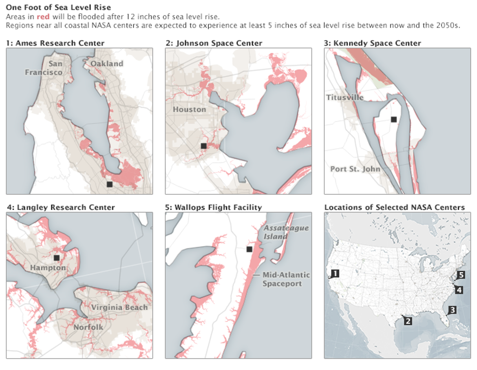
Thaller said there are two primary directives in progress on the agency level: creating a culture of sustainability and improving energy and water conservation. In addition, the president’s administration requires all agencies to create a climate action plan to help address climate change. NASA is already working on addressing climate change effects at their facilities, especially coastal launch ranges.
“We will continue to address climate resiliency within our facilities, so that we can continue to improve mission success,” Thaller said.
NASA Takes on Wildfires with Flight Demonstration
by Abigail Tabor
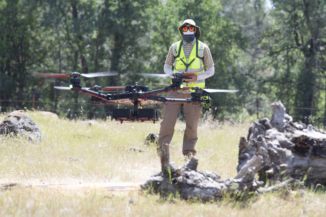
Helping make the battle against wildfires faster, safer, and more targeted, a NASA project recently tested its tools in a realistic wildland firefighting exercise. The Scalable Traffic Management for Emergency Response Operations project, or STEReO, aims to create a system that can be deployed during emergencies to coordinate multiple elements of disaster response. These may include aircraft, teams on the ground, and data collected from the air. Pictured here below is NASA drone pilot Jonas Jonsson, flying an uncrewed aircraft during a flight demonstration in Redding, California, on May 5, 2021. STEReO’s partners at the California Department of Forestry and Fire Protection, or CAL FIRE, and the U.S. Forest Service flew wildfire-fighting aircraft in coordination with NASA drones like this one, using STEReO’s system to keep all parties informed of the ongoing operations.
Dialogue with the wildfire management community continued on May 13, with a workshop hosted by NASA’s Aeronautics Research Mission Directorate, in collaboration with the Space Technology and Science Mission Directorates. More than 150 attendees worked to identify specific challenges facing stakeholders, from prediction and detection of wildfire, to mitigation and remediation efforts after a fire. Participants identified the need for persistent surveillance of wildfire-prone areas, a common operating picture for all responders, and near real-time data streams in support of actions. Better coordination and data sharing across all levels of government, along with artificial intelligence and machine learning tools, were also considered necessary to the effort. This input will inform potential NASA contributions and collaborations to improve the state of the art in wildfire management.
The workshop followed and built upon a meeting of the Tactical Fire Remote Sensing Advisory Committee, a group composed of the larger wildfire management community that aims to prioritize development of technologies to fill information gaps. The NASA event attracted a diverse group involved in wildfire management, including government organizations, such as the U.S. Air Force, U.S. Forest Service, U.S. Geological Survey, National Guard, and CAL FIRE, the firefighter community, industry, and academia.
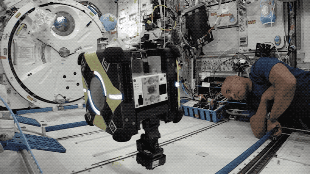
Sticking Around: Astrobee Tests Gecko-Inspired Adhesives in Space
by Gianine Figliozzi
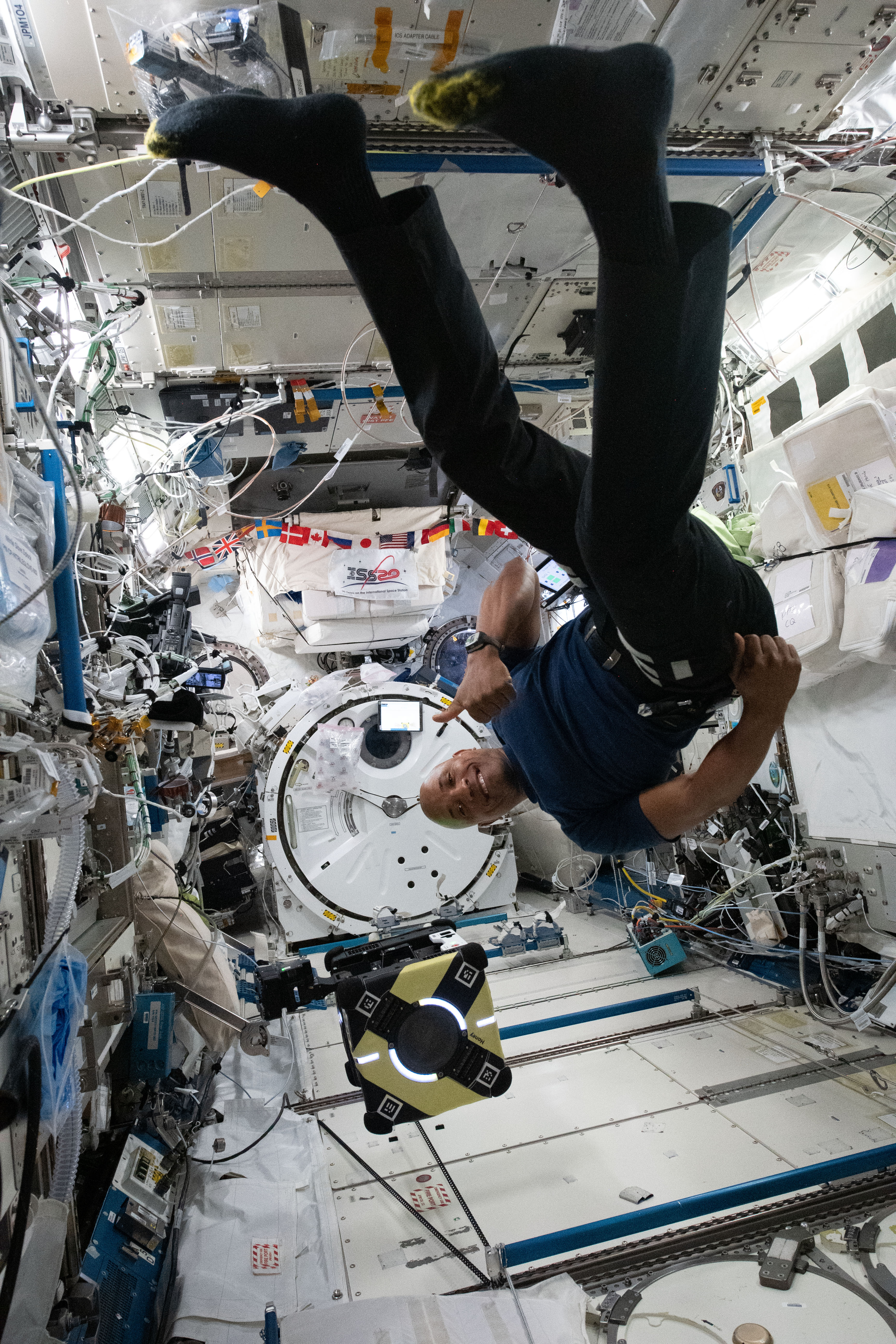
NASA astronaut Victor Glover works with an Astrobee robot, named “Honey,” to test a mechanical adhesive technology inspired by gecko feet. Astrobee’s facility, managed by NASA’s Ames Research Center in California’s Silicon Valley, provides guest scientists with a platform for zero-gravity robotics research inside the International Space Station. This technology, developed by Stanford University, in Stanford, California offers a new capability for free-flying robots in space. Dubbed the gecko gripper, this device allows robots to grab onto surfaces – without applying force to adhere – and then detach on demand. This simplifies grasping and manipulating objects in space and will provide more places for robots to perch, even outside spacecraft, as such adhesives can be used in the vacuum of space. This technology will pave the way for future, exterior spacecraft maintenance and exploration tasks done by robots. The enhanced capability for robotic assistants means crew can spend less time on routine chores such as unpacking supplies or fetching tools, and focus more on tasks only humans can do.