


![Request for Information – Potential [Placeholder for Prize]](https://assets.science.nasa.gov/dynamicimage/assets/science/psd/solar/2023/09/s/solarsystem_0.jpg?w=1024)


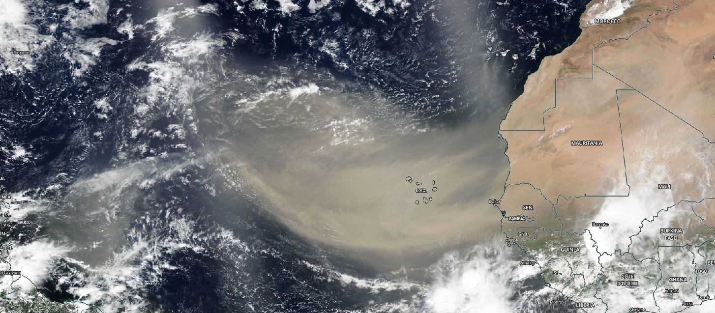
NASA-NOAA’s Suomi NPP satellite observed a huge Saharan dust plume streaming over the North Atlantic Ocean, beginning on June 13. Satellite data showed the dust had spread over 2,000 miles.
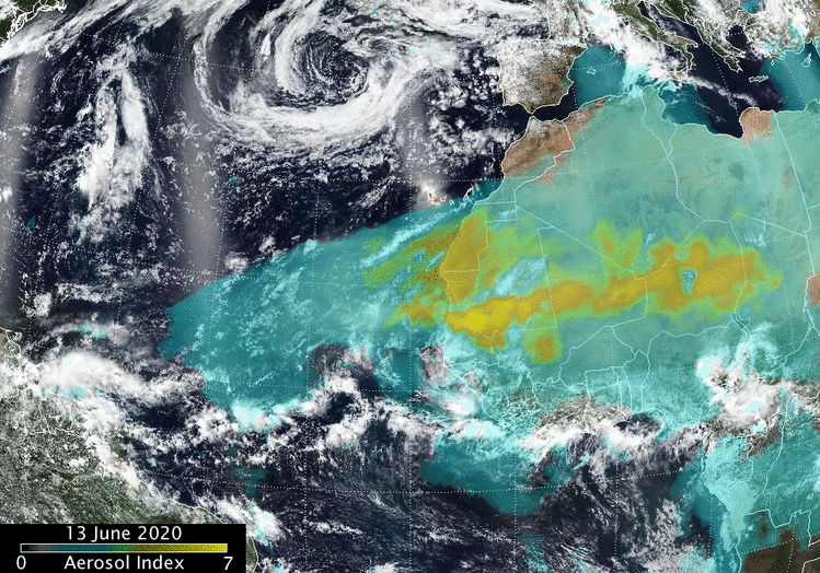
At NASA’s Goddard Space Flight Center in Greenbelt, Maryland, Colin Seftor, an atmospheric scientist, created an animation of the dust and aerosols from the plume using data from instruments that fly aboard the Suomi NPP satellite.
“The animation runs from June 13 to 18 and shows a massive Saharan dust cloud that formed from strong atmospheric updrafts that was then picked up by the prevailing westward winds and is now being blown across the Atlantic and, eventually over North and South America,” Seftor said. “The dust is being detected by the aerosol index measurements from the Suomi-NPP Suomi NPP satellite’ s Ozone Mapping and Profiler Suite (OMPS) data overlaid over visible imagery from the Visible Infrared Imaging Radiometer Suite (VIIRS).”
On June 18, 2020, the VIIRS instrument aboard NASA-NOAA’s Suomi NPP satellite captured a visible image of the large light brown plume of Saharan dust over the North Atlantic Ocean. The image showed that the dust from Africa’s west coast extended almost to the Lesser Antilles in the eastern North Atlantic Ocean. The image showed that the dust had spread over 2,000 miles across the Atlantic.
Normally, hundreds of millions of tons of dust are picked up from the deserts of Africa and blown across the Atlantic Ocean each year. That dust helps build beaches in the Caribbean and fertilizes soils in the Amazon. It can also affect air quality in North and South America.
NASA continues to study the role of African dust in tropical cyclone formation. In 2013, one of the purposes of NASA’s HS3 field mission addressed the controversial role of the hot, dry and dusty Saharan Air Layer in tropical storm formation and intensification and the extent to which deep convection in the inner-core region of storms is a key driver of intensity change.
Suomi NPP represents a critical first step in building the next-generation Earth-observing satellite system that will collect data on long-term climate change and short-term weather conditions. NPP is the result of a partnership between NASA, the National Oceanic and Atmospheric Administration, and the Department of Defense.
For more than five decades, NASA has used the vantage point of space to understand and explore our home planet, improve lives and safeguard our future. NASA brings together technology, science, and unique global Earth observations to provide societal benefits and strengthen our nation. Advancing knowledge of our home planet contributes directly to America’s leadership in space and scientific exploration.
For more information about NASA-NOAA’s Suomi NPP satellite, visit: www.nasa.gov/npp
By Rob Gutro
NASA’s Goddard Space Flight Center