![Request for Information – Potential [Placeholder for Prize]](https://assets.science.nasa.gov/dynamicimage/assets/science/psd/solar/2023/09/s/solarsystem_0.jpg?w=1024)


Communities worldwide now have access to a powerful tool to increase their awareness of landslide hazards, thanks to NASA and the Pacific Disaster Center.
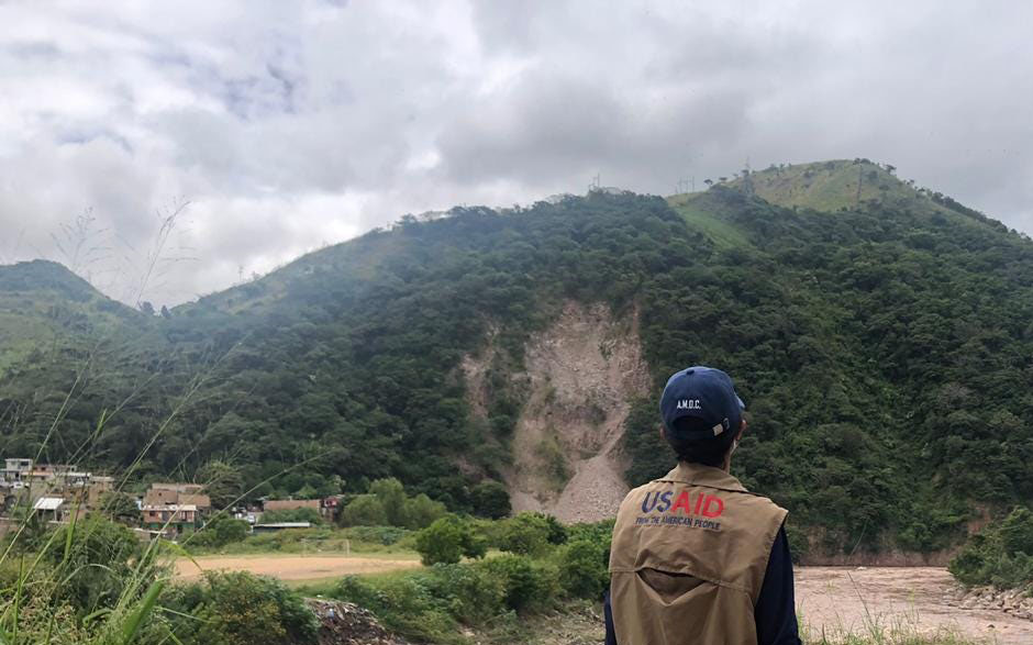
After years of development and testing, NASA’s Landslide Hazard Assessment for Situational Awareness model (LHASA) has been integrated into the Pacific Disaster Center’s (PDC) multi-hazard monitoring, alerting, and decision-support platform, DisasterAWARE. LHASA allows researchers to map rainfall-triggered landslide hazards, giving DisasterAWARE users around the world a robust tool for identifying, tracking, and responding to these threats. The aim is to equip communities with timely and critical risk awareness that bolsters disaster resilience and safeguards lives and livelihoods.
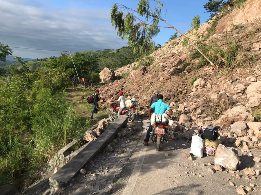
Landslides cause thousands of deaths and billions of dollars in damage every year. Developing countries often bear disproportionate losses due to lack of access to hazard early warning systems and other resources for effective risk reduction and recovery. Reports from the United Nations Office for Disaster Risk Reduction emphasize that early warning systems and early action are among the most effective ways to decrease disaster-related deaths and losses.
“Some local authorities develop their own systems to monitor landslide risk, but there isn’t a global model that works in the same way. That’s what defines LHASA: it works all the time and it covers most regions of the world,” says Robert Emberson, NASA Disasters associate program manager and a key member of the NASA landslides team. “Thanks to our collaboration with the Pacific Disaster Center, this powerful landslide technology is now even more accessible for the communities that need it most.”
LHASA uses a machine learning model that combines data on ground slope, soil moisture, snow, geological conditions, distance to faults, and the latest near real-time precipitation data from NASA’s IMERG product (part of the Global Precipitation Measurement mission). The model has been trained on a database of historical landslides and the conditions surrounding them, allowing it to recognize patterns that indicate a landslide is likely.
The result is a landslide “nowcast” – a map showing the potential of rainfall-triggered landslides occurring for any given region within the past day. This map of hazard likelihood can help agencies and officials rapidly assess areas where the current landslide risk is high. It can also give disaster response teams critical information on where a landslide may have occurred so they can investigate and deploy life-saving resources.
Partnering to Protect the Vulnerable
Generating landslide nowcasts is merely the first step. To be truly effective, vulnerable communities must receive the data in a way that is accessible and easy to integrate into existing disaster management plans. That’s where the Pacific Disaster Center comes in.
PDC is an applied research center managed by the University of Hawaii, and it shares NASA’s goal to reduce global disaster risk through innovative uses of science and technology. Its flagship DisasterAWARE software provides early warnings and risk assessment tools for 18 types of natural hazards and supports decision-making by a wide range of disaster management agencies, local governments, and humanitarian organizations. Prominent users include the International Federation of Red Cross and Red Crescent Societies (IFRC), the United Nations Office for the Coordination of Humanitarian Affairs (UN OCHA), and the World Food Programme (WFP).
“The close pairing of our organizations and use of PDC’s DisasterAWARE platform for early warning has been a special recipe for success in getting life-saving information into the hands of decision-makers and communities around the world,” said Chris Chiesa, PDC deputy executive director.
The collaboration with PDC brings NASA’s landslide tool to tens of thousands of existing DisasterAWARE users, dramatically increasing LHASA’s reach and effectiveness. Chiesa notes that teams in El Salvador, Honduras, and the Dominican Republic have already begun using these new capabilities to assess landslide hazards during the 2023 rainy season.
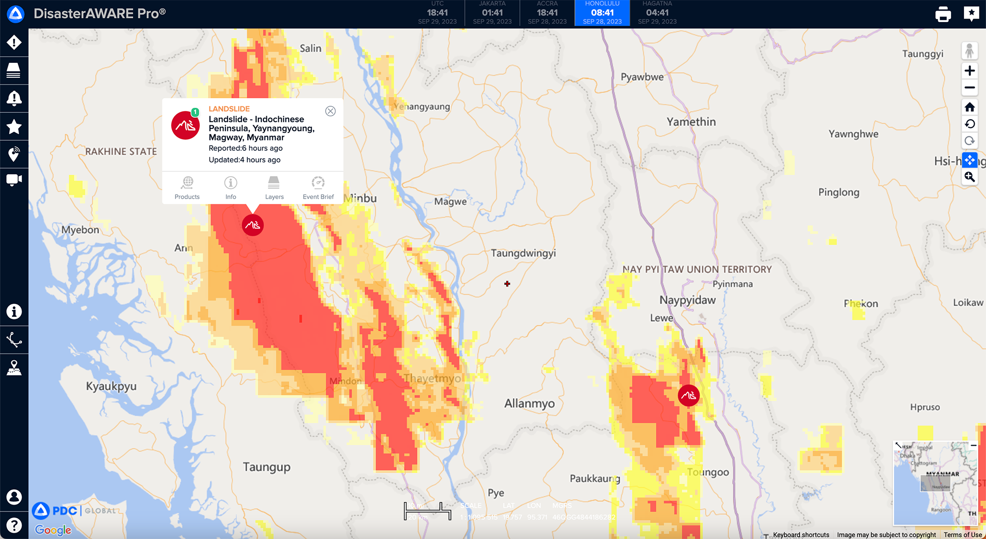
PDC’s software ingests and interprets LHASA model data and generates maps of landslide risk severity. It then uses the data to generate landslide hazard alerts for a chosen region that the DisasterAWARE mobile app pushes to users. These alerts give communities critical information on potential hazards, enabling them to take protective measures.
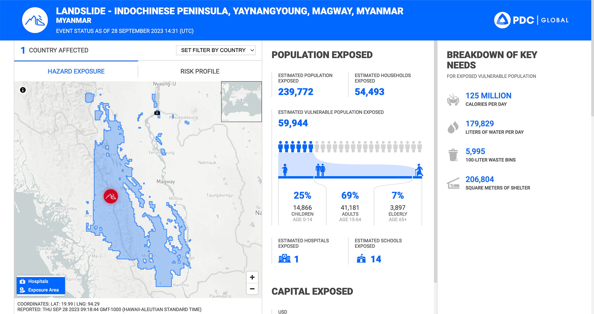
DisasterAWARE also creates comprehensive regional risk reports that estimate the number of people and infrastructure exposed to a disaster – focusing specifically on things like bridges, roads, and hospitals that could complicate relief efforts when damaged. This information is critical for allowing decision-makers to effectively deploy resources to the areas that need them most.
This effort between NASA and the PDC builds upon a history of fruitful cooperation between the organizations. In 2022, they deployed a NASA global flood modeling tool to enhance DisasterAWARE’s flood early-warning capabilities. They have also shared data and expertise during multiple disasters, including Hurricane Iota in 2020, the 2021 earthquake in Haiti, and the devastating August 2023 wildfires in Maui, PDC’s base of operations.
“The LHASA model is all open-source and leverages publicly available data from NASA and partners,” says Dalia Kirschbaum, lead of the NASA landslides team and director of Earth Sciences at NASA’s Goddard Space Flight Center. “This enables other researchers and disaster response communities to adapt the framework to regional or local applications and further awareness at scales relevant to their decision-making needs.” Kirschbaum and her team were recently awarded the prestigious NASA Software of the Year award for their work developing LHASA.