


What is GPS?
The Global Positioning System (GPS) is a space-based radio-navigation system, owned by the U.S. Government and operated by the United States Air Force (USAF). It can pinpoint a three dimensional position to meter-level accuracy and time to the 10-nanosecond level, worldwide and 24/7.

GPS is comprised of three different parts:
- Space Segment: A constellation of at least 24 US government satellites distributed in six orbital planes inclined 55° from the equator in a Medium Earth Orbit (MEO) at about 20,200 kilometers (12,550 miles) and circling the Earth every 12 hours.
- Control Segment: Stations on Earth monitoring and maintaining the GPS satellites.
- User Segment: Receivers that process the navigation signals from the GPS satellites and calculate position and time.
History of GPS
GPS has its origins in the Sputnik era when scientists were able to track the satellite with shifts in its radio signal, known as the “Doppler Effect,” which became the foundational idea for modern GPS. Today the GPS satellite constellation (the space segment) consists of over 30 operational satellites, each equipped with redundant atomic clocks and tracked by a ground control network (the control segment). Each satellite transmits its position and time at regular intervals and those signals are intercepted by GPS receivers (the user segment). The receiver is able to determine its position by calculating how long it took for the signals to reach it.
In the early 1970’s, the Department of Defense (DoD) wanted to ensure a robust, stable satellite navigation system would be available. Embracing previous ideas from Navy scientists, the DoD decided to use satellites to support their proposed navigation system. DoD then followed through and launched its first Navigation System with Timing and Ranging (NAVSTAR) satellite in 1978. The 24 satellite system became fully operational in 1993.
Today, GPS is a multi-use, space-based radio-navigation system owned by the US Government and operated by the United States Air Force to meet national defense, homeland security, civil, commercial, and scientific needs. GPS currently provides two levels of service: Standard Positioning Service (SPS) which uses the coarse acquisition (C/A) code on the L1 frequency, and Precise Positioning Service (PPS) which uses the P(Y) code on both the L1 and L2 frequencies. Access to the PPS is restricted to US Armed Forces, US Federal agencies, and selected allied armed forces and governments. The SPS is available to all users on a continuous, worldwide basis, free of any direct user charges. The specific capabilities provided by SPS are published in the Global Positioning System Performance Standards and Specifications.
NASA's Use of GPS
NASA’s mission to pioneer the future in space exploration, scientific discovery and aeronautics research necessitates the proactive development and implementation of a number of GPS applications to enable greater spacecraft autonomy and more advanced space science and Earth monitoring applications. To accomplish this, NASA works alongside the USAF to continue improving GPS capabilities to support space operation and science applications.
Space Communications
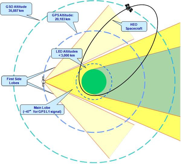
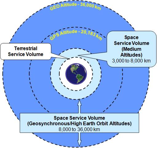
NASA users in orbit can determine their position and time using communications channel tracking via the Deep Space Network (DSN), Near Space Network (NSN), or by on-board means of processing one-way radio-navigation signals from Global Navigation Satellite Systems (GNSS), such as the US Global Positioning System (GPS). The DSN is also capable of supporting tracking from Low Earth Orbit (LEO) through interplanetary transfer domains. While NASA missions primarily use communication channel tracking by the DSN and NSN for trajectory analysis, individual missions may choose to also use GPS measurements as an observable or backup out to Geosynchronous Orbit (GEO – 36,000 Km) as acceptance of GPS for a positioning source becomes more widespread.
Spacecraft Orbit and Trajectory Determination
Traditionally, space missions have determined their orbit by using communications channel tracking, in which a Flight Dynamics Facility uses positioning information from two-way communication signals between the spacecraft and a ground station or relay satellite to calculate the spacecraft’s orbit. Alternatively, missions that choose to use GPS to determine their position track radio-navigation signals from GPS satellites and process these signals on-board to determine position and time. This increases spacecraft autonomy, enables new methods of spaceflight operations and reduces the burden on NASA’s tracking stations.
Science Applications
GPS is used as a remote sensing tool to support atmospheric and ionospheric sciences, geodesy and geodynamics – from monitoring sea levels and ice melt to measuring the Earth’s gravity field. SCaN and NASA’s Science Mission Directorate have partnered to improve the performance of the GPS constellation through policy advocacy for modernization improvements via the GPS requirements process, the National Space-based Positioning, Navigation, and Timing (PNT) Executive Committee and the National Space-based PNT Advisory Board.
One example is NASA leadership of an interagency team working to place laser retro-reflectors on the next generation of GPS, known as GPS III. Enabling satellite laser ranging to GPS and other GNSS constellations allows for systematic errors in the radiometric data to be identified and corrected. This information could then be used to improve the Earth-centered terrestrial reference frame that GPS positioning is based on, leading to millimeter level accuracies. This would generate a terrific increase in performance and precision that would allow scientists the word over to do such things as measure climate change effects by monitoring ice melt or sea levels. SMD is planning to purchase the reflectors, while also continuing its funding to the International Laser Ranging System (ILRS), which is an international network of ground laser tracking stations. The primary mission of ILRS is to support geodetic and geophysical research.
Autonomy of Spacecraft Operations
GPS, and other GNSS systems such as the Russian GLONASS constellation, may be used to enable more on-board autonomous navigation. GPS-based navigation uses one-way signals from GPS satellites to determine the spacecraft’s trajectory through its on-board instruments and data processing. GPS currently provides real-time on-board three dimensional position and time with a 95% accuracy of approximately 10 meters horizontally and 20 meters vertically per performance standards, however in reality the actual mission performance can be much better depending on the scenario or application. GPS may also provide accurate time synchronization and attitude determination (in lieu of other sensors, such as star trackers). The actual User Ranger Error (URE) on a global average has been demonstrated to be as precise as one meter or better in recent years.
GPS Receiver Development
NASA has developed, and continues to improve, GPS flight and science receivers that are already in use.
Benefits of GPS to Users in High Earth Orbit
- Significantly improves real-time navigation performance from km-class to meter-class
- Supports quick trajectory maneuver recovery from 5-10 hours to minutes
- Timing capabilities reduce a spacecraft’s need for expensive on-board clocks
- Supports increased satellite autonomy, lowering mission operations costs
- Enables new and enhanced capabilities and better performance for users in high-Earth orbit and Cislunar space
Future of GPS
Worldwide government and commercial spacecraft launch projections over the next two decades show that approximately 60 percent of future missions will operate in low-Earth orbit and 95 percent of missions will operate at or below geosynchronous orbit. NASA will continue to protect current investments and improve upon existing capabilities by working alongside other U.S. Government agencies and pursuing compatibility and interoperability with other Global Navigation Satellite System (GNSS) constellations.
Since most future missions will utilize GPS satellite signals for tracking, NASA is developing specialized GPS receivers for space applications, many of which are already in use:
- The Navigator Receiver from NASA Goddard Space Flight Center (GSFC) utilizes the L1 C/A signal. This receiver flew on the Servicing Mission 4 for the Hubble Space Telescope in May 2009 and proved to be very successful. A number of future missions in HEO, GEO and MEO plan to work with this receiver using its high sensitivity signal acquisition and tracking capabilities.
- The BlackJack Flight GPS Receiver from the Jet Propulsion Laboratory (JPL) utilizes both the L1 and L2 frequencies, with eighteen receivers already in orbit tracking GPS signals. The newly emerging Triple GNSS (TriG) Receiver is under development, with the capability to track a number of GPS and other GNSS signals, to include the Russian GLONASS and the European Galileo constellations.