


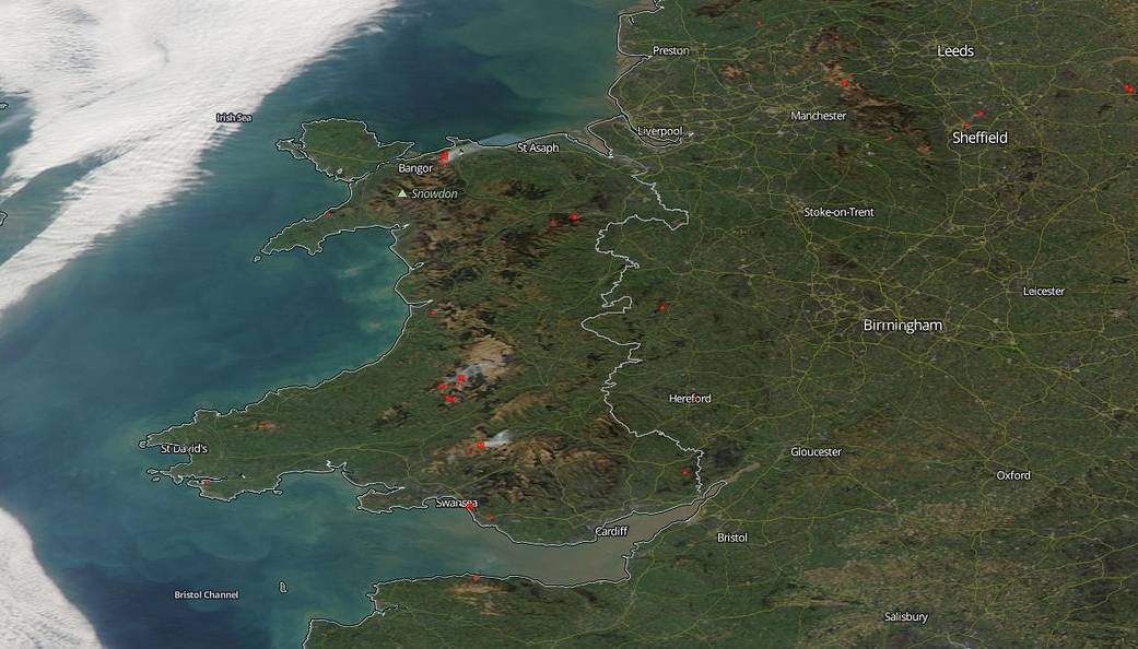
Prescribed or “controlled burning” seems to be occurring in parts of Wales as there have been no fire alerts in the areas where the fires were spotted on this Aqua satellite image. According to Craig Hope, a wildfire officer with the South Wales Fire and Rescue Service, “Wales has an open burning season from October 1 through March 31 each year. n Wales the burning of vegetation is used to encourage new grass for grazing. Fires are very common in mid-February, but the warmer temperatures in February that have been recorded could suggest signs of global warming.”
Climate scientists have also noted that fires tend to break out when temperatures rise because the rise in temperatures create more extreme weather including dangerous thunderstorms. Thunderstorms produce lightning which ignite fires. In addition the warmer weather tends to dry out crops and grasslands which provides more tinder once the lightning strikes.
Where there’s fire there’s smoke and that introduces yet another serious issue to consider. The smoke released by any type of fire is a mixture of particles and chemicals produced by incomplete burning of carbon-containing materials. All smoke contains carbon monoxide, carbon dioxide and particulate matter (PM or soot). Exposure to high levels of smoke should be avoided especially those individuals with cardiovascular or respiratory conditions (e.g., asthma), fetuses, infants, young children, and the elderly may be more vulnerable to the health effects of smoke exposure.
NASA’s Earth Observing System Data and Information System (EOSDIS) Worldview application provides the capability to interactively browse over 700 global, full-resolution satellite imagery layers and then download the underlying data. Many of the available imagery layers are updated within three hours of observation, essentially showing the entire Earth as it looks “right now.” This satellite image was collected on Feb. 28, 2019 with NASA’s Aqua satellite. Actively burning fires, detected by thermal bands, are shown as red points. Image Courtesy: NASA Worldview, Earth Observing System Data and Information System (EOSDIS). Caption: Lynn Jenner with information from Craig Hope of the South Wales Fire and Rescue Service