


NASA Sees Remnants of Tropical Cyclone Champi Warming and Raining on Alaska
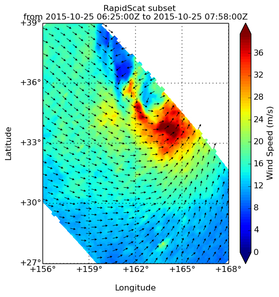
Former western North Pacific Ocean typhoon Champi weakened and transitioned into an extra-tropical cyclone and moved east across the Pacific. On October 26, satellite imagery showed the extra-tropical cyclone affecting Alaska, where it was bringing rain, gusty winds and warmer than normal temperatures. NOAA’s GOES-West satellite and NASA’s RapidScat instrument captured the powerful former typhoon near Alaska.
RapidScat is an instrument that flies aboard the International Space Station and measures surface winds over open waters of oceans. RapidScat gathered wind speed and direction data on former typhoon Champi on Oct. 25 and revealed that the storm was still packing quite a punch. Strongest sustained winds were south and east of the center near 36 meters per second/70 knots/80.5 mph/129.6 kph).
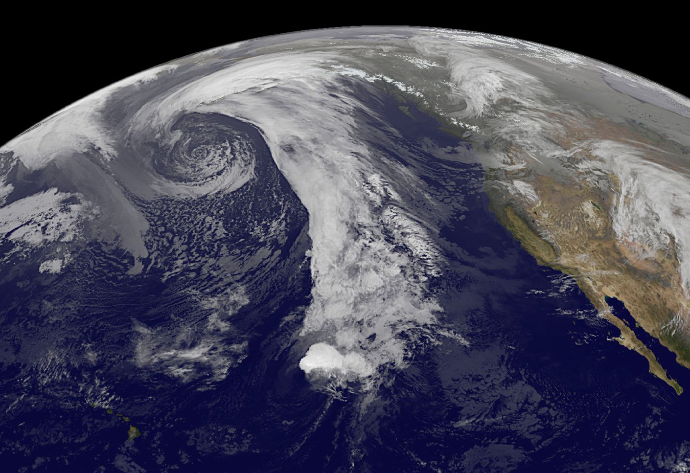
On October 26, there were two low pressure areas affecting Alaska, according to the National Weather Service in Anchorage, Alaska. Both low pressure areas are powerful. One is centered just south of Russia’s Kamchatka peninsula and the other was south of the Alaska Peninsula around 48 degrees North latitude. The low near the Alaska Peninsula is the leftover remnants of former Typhoon Champi.
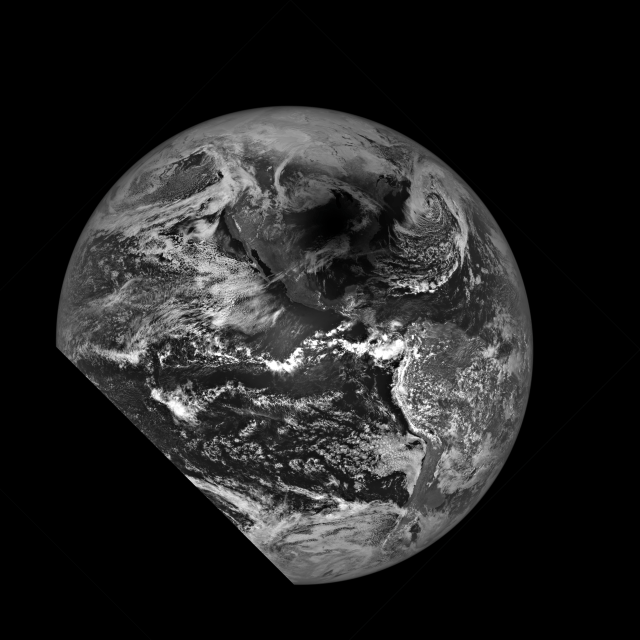
On October 26 at 1200 UTC, NOAA’s GOES-West satellite captured an infrared image of Champi’s remnants that looked more like a frontal system. Ex-tropical cyclone Champi was rapidly weakening south of Shemya and moving south of the Aleutian Islands.
The National Weather Service forecast for Monday, Oct. 26 calls for cloudy skies with rain and mild temperatures near 50 degrees Fahrenheit. Champi’s remnants are kicking up winds with east winds expected between 30 to 35 mph, with gusts as high as 50 mph. At night the rain is expected to be heavy at times, with accumulations between 1 and 2 inches as east winds continue between 35 to 40 mph. The Tuesday forecast calls for rain to continue with accumulations up to an inch, gusty winds and a mild high temperature near 49. East winds for Tuesday, October 27 are forecast around 35 mph, with gusts as high as 50 mph.
At 5:27 a.m. AKDT on October 26, the warm air occlusion wrapping around the low pressure area formerly known as Champi was starting to push through the Alaska peninsula and into Bristol Bay. The National Weather Service said that it will bring widespread precipitation…some of which could be heavy along the higher terrain. In addition, it is expected to keep the gusty winds blowing on Monday, October 26 and Tuesday, October 27 as the front stalls.
Champi’s remnants are also bringing warmer than normal temperatures to Alaska. NWS noted that “the entire region will remain above normal for both high and low temperatures. Places in The lee of the mountains where downsloping winds occur…such as King Salmon…will continue to run as much as 15 degrees Fahrenheit above normal.”
For updated Anchorage forecasts, visit the NWS website: www.weather.gov.
Rob Gutro
NASA’s Goddard Space Flight Center
Oct. 23, 2015 – NASA Satellite Sees Typhoon Champi Elongating
Typhoon Champi appeared to be the victim of vertical wind shear in infrared imagery from NASA’s Terra satellite. Champi has become elongated while moving through the western North Pacific Ocean and is expected to become extra-tropical by October 24.
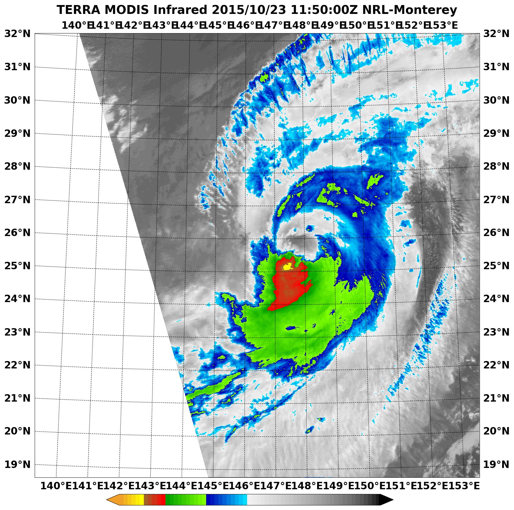
On October 23 at 1150 UTC (7:50 a.m. EDT) the Moderate Resolution Imaging Spectroradiometer or MODIS instrument aboard NASA’s Terra satellite showed evidence of wind shear in Typhoon Champi as its clouds stretched from southwest to northeast. The Joint Typhoon Warning Center said that satellite imagery showed “a ragged eye feature with continued deterioration of the convective structure as it becomes further elongated to the northeast.”
It was located near 25.7 degrees north latitude and 148.1 east longitude, about 643 nautical miles north of Saipan. Champi had maximum sustained winds near 80 knots (92.0 mph/148.2 kph). It was moving to the east at 15 knots (17.2 mph/27.7 kph).
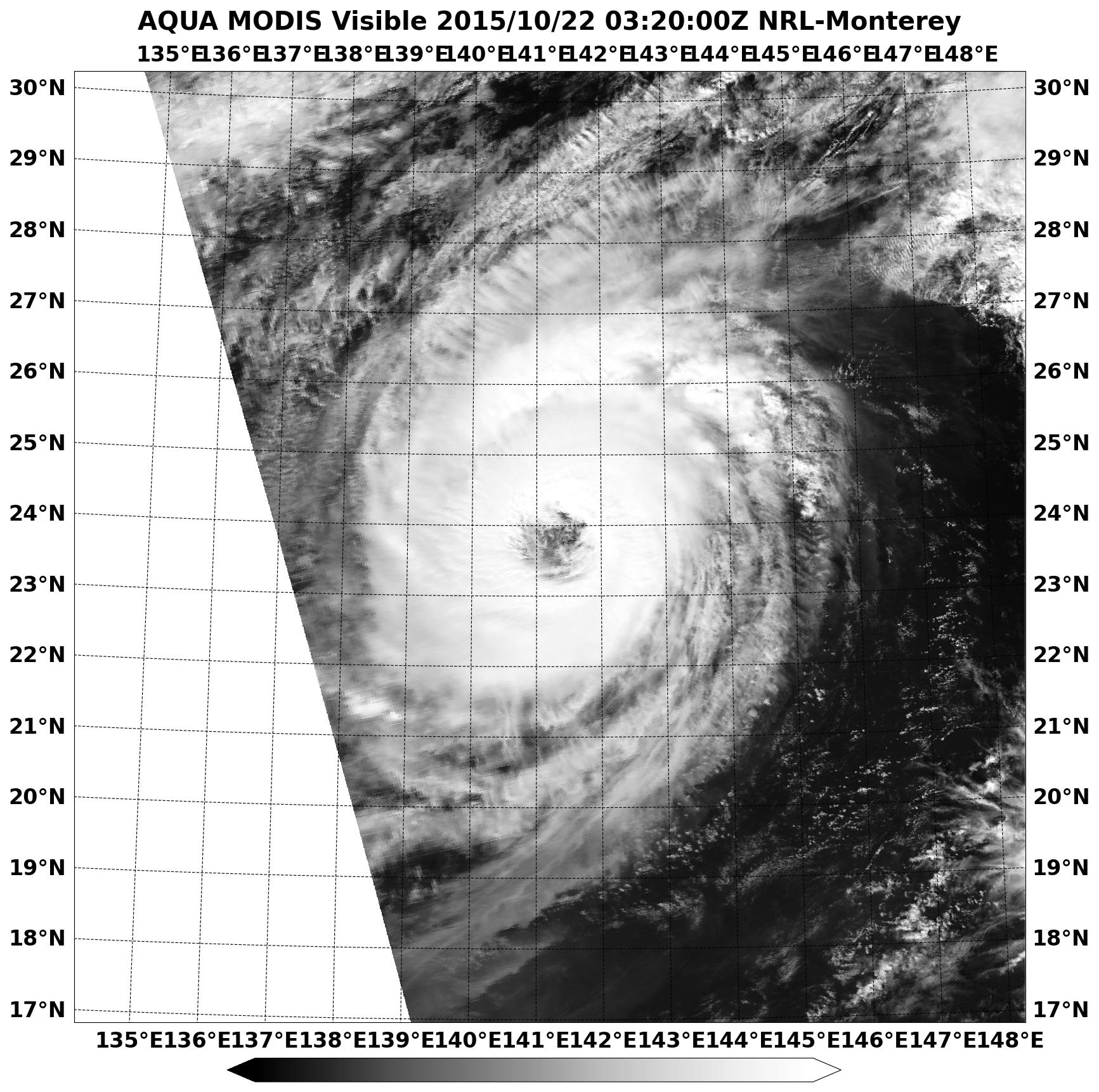
The Moderate Resolution Imaging Spectroradiometer or MODIS instrument aboard NASA’s Aqua satellite captured a visible image of extra-tropical cyclone 26W on October 23 at 0225 UTC (Oct. 22 at 10:25 p.m. EDT). The MODIS image showed evidence of wind shear as the bulk of clouds were pushed from the southwest to the northeast of the center.
The Joint Typhoon Warning Center noted that upper level (atmospheric) analysis indicated that Champi was in a poor environment with vertical wind shear in excess of 30 knots (34. 5 mph/55.5 kph).
The Joint Typhoon Warning Center expects Champi to continue moving east and weaken before transitioning to an extra-tropical system on Saturday, October 24.
Rob Gutro
NASA’s Goddard Space Flight Center
Oct. 22, 2015 – NASA Gets Clear Look Into Typhoon Champi’s 36-Nautical-Mile-Wide Eye
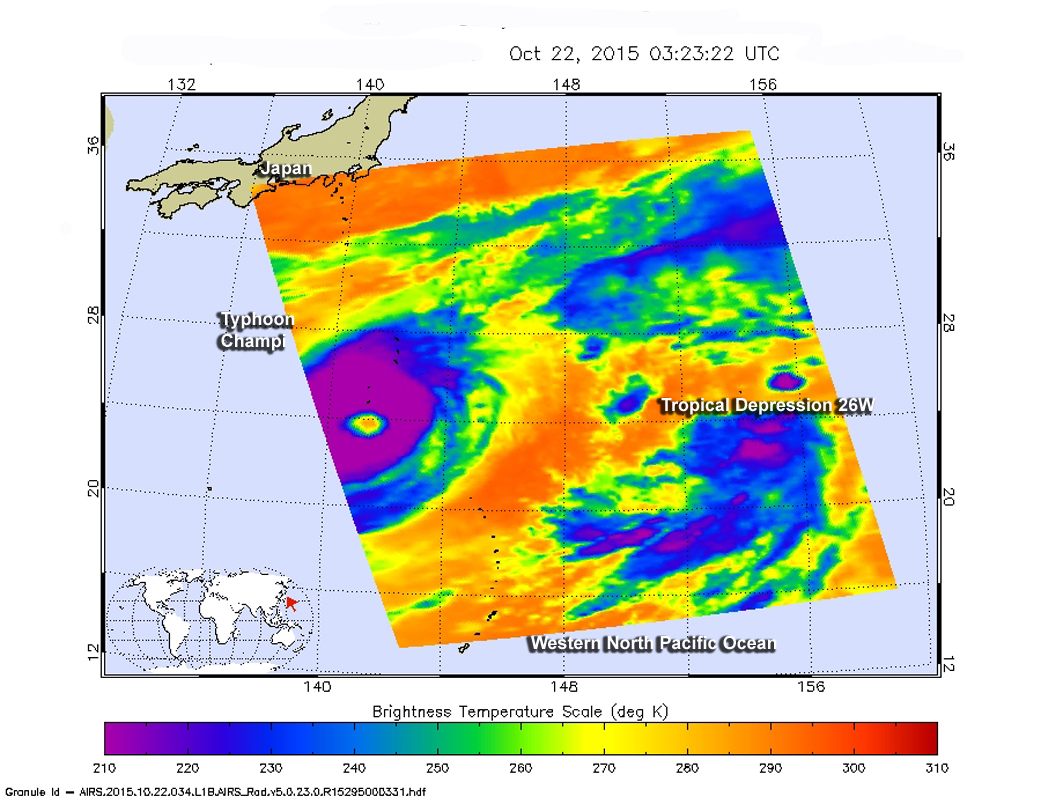
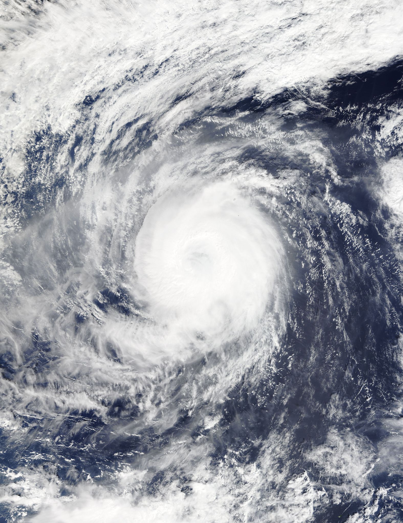
When the eye of a tropical cyclone is 36 nautical miles (41.4 mile/ 66.7 km) wide, it’s pretty easy to spot from NASA’s Aqua satellite in orbit. On October 22, 2015, two instruments aboard Aqua saw the large eye surrounded by powerful thunderstorms. Champi’s eye was very close to the island of Iwo To, Japan.
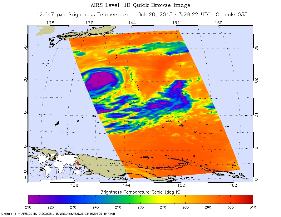
At 03:23 UTC on October 22 ((11:23 p.m. EDT, Oct. 21) the Moderate Resolution Imaginge Spectroradiometer or MODIS instrument aboard NASA’s Aqua satellite saw the large eye in Typhoon Champi, At the same time, the infrared instrument called the Atmospheric Infrared Sounder or AIRS instrument that also flies aboard Aqua looked at the storm. In a wider view, AIRS also saw newborn Tropical Depression 26W to the east of Champi in the western North Pacific Ocean. The image also clearly showed the large eye in Champi, where cloud top temperatures exceeded minus 63 Fahrenheit / minus 53 Celsius. Temperatures that cold indicate storms high in the troposphere with strong uplift and the ability to generate heavy rainfall. Forecasters at the Joint Typhoon Warning Center noted “The system continues to be elongated to the northeast as it interacts with the mid-latitude westerly flow.”
At 1500 UTC (11 a.m. EDT) on October 22, 2015, Champi’s maximum sustained winds were near 100 knots (115 mph/185 kph). It was centered just 53 nautical miles (60.9 miles/98.1 km) south-southeast of Iwo To, Island, Japan, near 24.0 degrees north latitude and 141.7 degrees east longitude. With a 36 nautical mile (41.4 mile/ 66.7 km)-wide eye, that puts Iwo To very close to the eye.
Champi was moving to the northeast at 5 knots (5.7 mph/9.2 kph) and generating rough seas with wave heights to 34 feet (10.3 meters). Champi is moving slowly east. The storm is expected to maintain current strength over the next day or two before becoming an extra-tropical system in the North Pacific Ocean.
Rob Gutro
NASA’s Goddard Space Flight Center
Oct. 21, 2015 – NASA’s GPM Satellite Sees Typhoon Champi Still Going Strong
The Global Precipitation Measurement mission, or GPM, core satellite is getting a workout in the western North Pacific Ocean as it gathered rainfall and cloud height data on Typhoon Champi.
Both Typhoon Champi and Super-typhoon Koppu formed on Oct. 13, 2015. Champi is still a typhoon because it stayed over the open waters of the Pacific Ocean, but Super-typhoon Koppu’s strength was sapped by its travel over the rugged terrain of the Philippines.
The GPM core observatory satellite passed above Typhoon Champi on Oct. 21, 2015 at 0110 UTC (7:01 a.m. EDT). Maximum sustained winds were still about 75 knots (86 mph) at the time GPM passed overhead.
Rainfall data derived from data captured by GPM’s Microwave Imager (GMI) instrument reveal that Typhoon Champi had a large eye. Rain was measured in the eyewall falling at a rate of 56.7 mm (2.23 inches) per hour.
GPM’s Dual-Frequency Precipitation Radar (DPR) instrument made 3-D measurements of precipitation on Typhoon Champi’s eastern side. Those measurements showed that some storm top heights there were reaching altitudes of 13.7 km (8.5 miles).
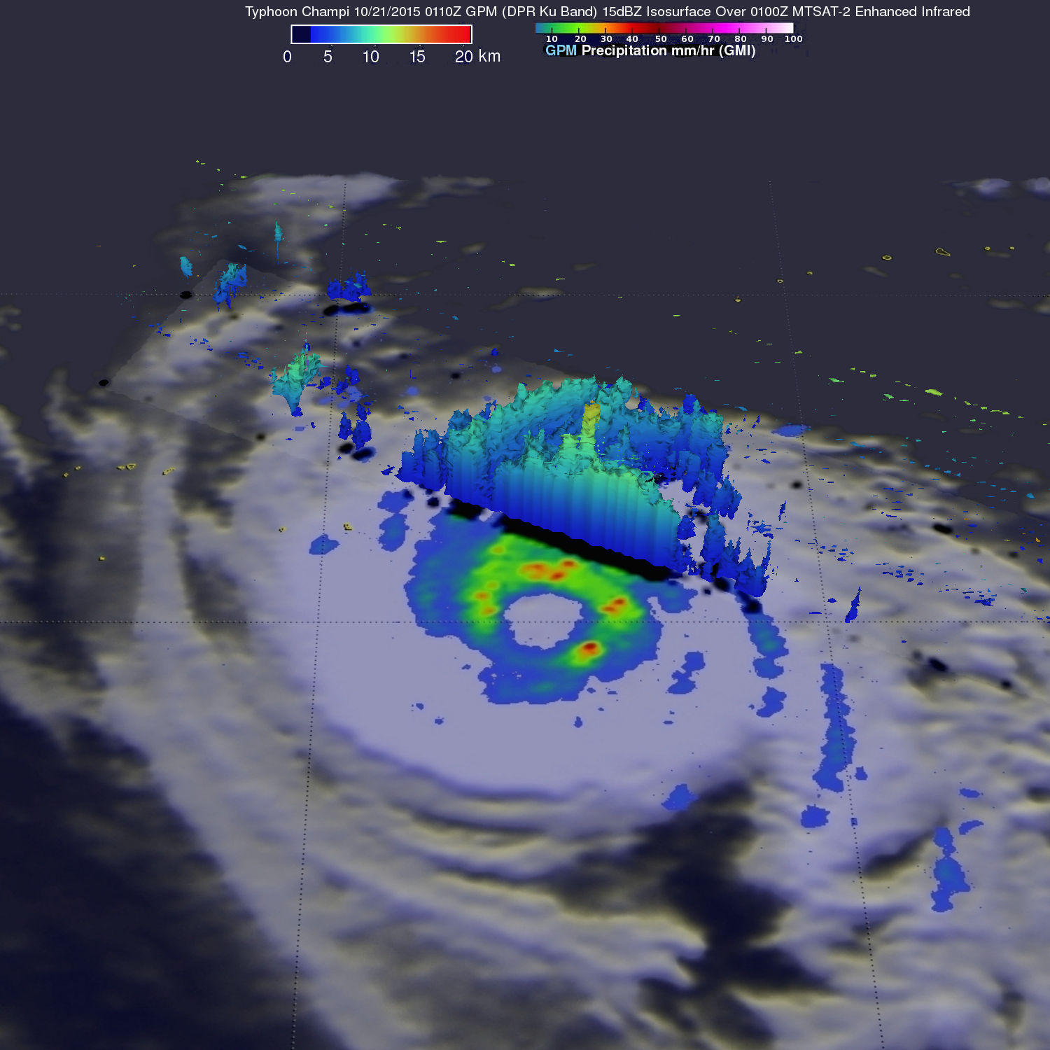
At 1500 UTC (11 a.m. EDT), Typhoon Champi’s maximum sustained winds were near 75 knots (86.3 mph/138.9 kph). It was centered near 23.2 degrees north latitude and 140.4 degrees east longitude, about 108 miles south-southwest of Iwo To, Japan. It was moving to the north at 4 knots (4.6 mph/7.4 kph) and generating wave heights to 30 feet (9.1 meters).
The Joint Typhoon Warning Center (JTWC) has predicted that Typhoon Champi will become a little more powerful with peak winds of 85 knots (98 mph) tomorrow, October 22. Within a few days increasing vertical wind shear and colder sea surface temperatures are expected to weaken the system.
Hal Pierce
SSAI/NASA’s Goddard Space Flight Center, Greenbelt, Maryland
Oct. 20, 2015 – NASA Sees Typhoon Champi Near Iwo To, Japan
Typhoon Champi was near Iwo To island, Japan when NASA’s Terra and Aqua satellites gathered data on the weakening typhoon.
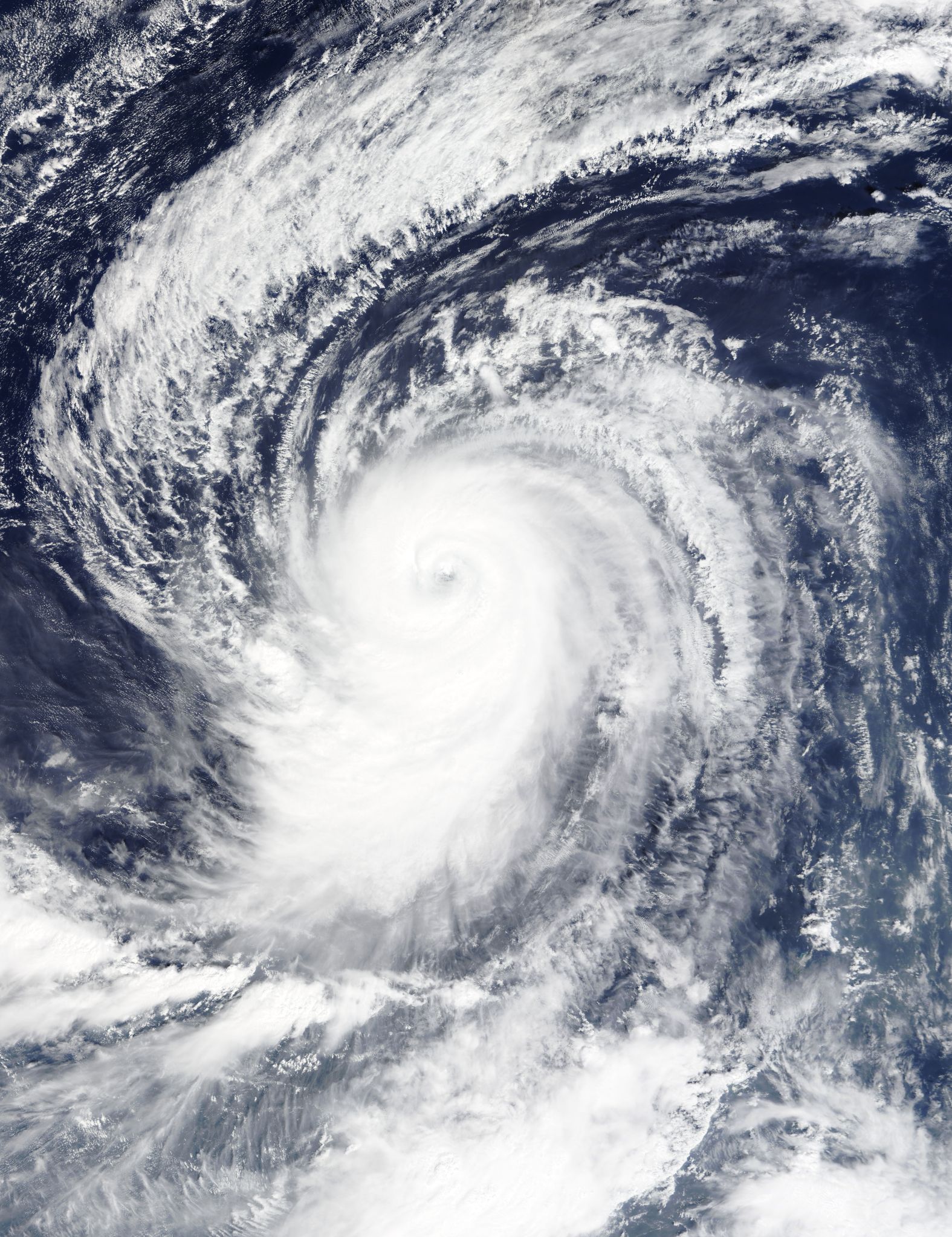
Typhoon Champi still maintained an eye on visible imagery taken by the Moderate Resolution Imaging Spectroradiometer on Oct. 19 at 01:25 UTC. At that time, the storm also appeared symmetric as powerful bands of thunderstorms spiraled into the low-level center, but the storm was weakening.
On October 20 at 0329 UTC (Oct. 19 at 11:29 p.m. EDT) NASA’s Aqua satellite flew over Champi after it had weakened somewhat. The AIRS instrument or Atmospheric Infrared Sounder instrument that flies aboard Aqua looked at the storm in infrared light, and gathered temperature data. In the AIRS image, the eye was no longer visible, and a large band of thunderstorms wrapped into the center from the northwest, north of the center to the east. Another band of thunderstorms wrapped outside the center from the east-southeast to the west-southwest and spiraled into the low-level center.
At 1500 UTC (11 a.m. EDT) Champi was just southwest of the island of Iwo To, Japan and moving to the northeast. Maximum sustained winds dropped from 90 knots (103.6 mph/166 kph) just six hours before, to 80 knots (92 mph/148 kph). Champi is on a weakening trend.
At 11 a.m. EDT, NOAA’s National Weather Service reported weather conditions at Iwo To noted conditions were mostly cloudy with winds from the east-south at 28 mph (24 knots) gusting to 44 mph (38 knots).
The Joint Typhoon Warning Center expects Champi to maintain typhoon status as it passes close to the island and heads out into the open waters of the northwestern Pacific Ocean over the next five days. Champi was centered near 22.3 north latitude and 140.0 east longitude, about 172 nautical miles south-southwest of Iwo To. Champi has tracked northward at 4 knots (4.6 mph/7.4 kph) and is generating rough seas with wave heights to 9.1 meters (30 feet).
Champi is moving slowly to the northwest and will gradually weaken before becoming an extra-tropical system after passing Iwo To.
Rob Gutro
NASA’s Goddard Space Flight Center, Greenbelt, Md.
Oct. 19, 2015 – NASA’s GPM Measured Typhoon Champi’s Heavy Rainfall
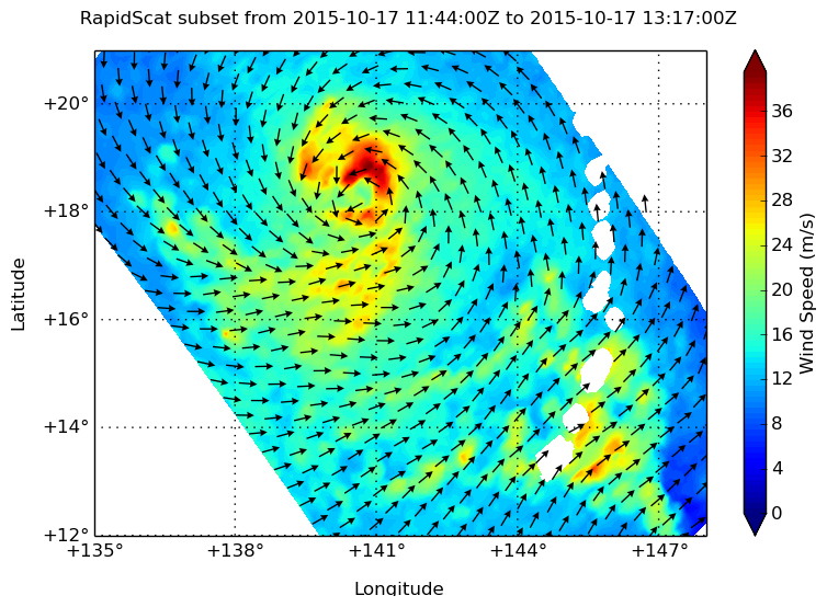
Typhoon Champi has been generating heavy rainfall since Oct. 16, 2015, when NASA’s Global Precipitation Measurement, or GPM, mission analyzed the storm. The storm intensified from a tropical storm to a typhoon after GPM passed overhead. The RapidScat instrument aboard the International Space Station also showed what side of the storm had the strongest winds.
On Oct. 16, 2015, at 0216 UTC the GPM core observatory satellite passed above Champi when it was a tropical storm drenching the Northern Marianas Islands. GPM’s Dual-Frequency Precipitation Radar (DPR) measured rain within Champi falling at a rate of over 114.8 mm (4.5 inches) per hour in a band of intense showers.
GPM’s radar sliced through Champi’s western side and made 3-D measurements of storm top heights. Radar reflectivity values found to be greater than 15 dBZ are shown in a simulated perspective 3-D view. The lowest heights are shaded blue and the tallest 3-D 15dBZ surfaces are colored red. GPM measured storm tops (orange) that were reaching altitudes above 16.5 km (10.2 miles) within a strong feeder band southwest of Guam.
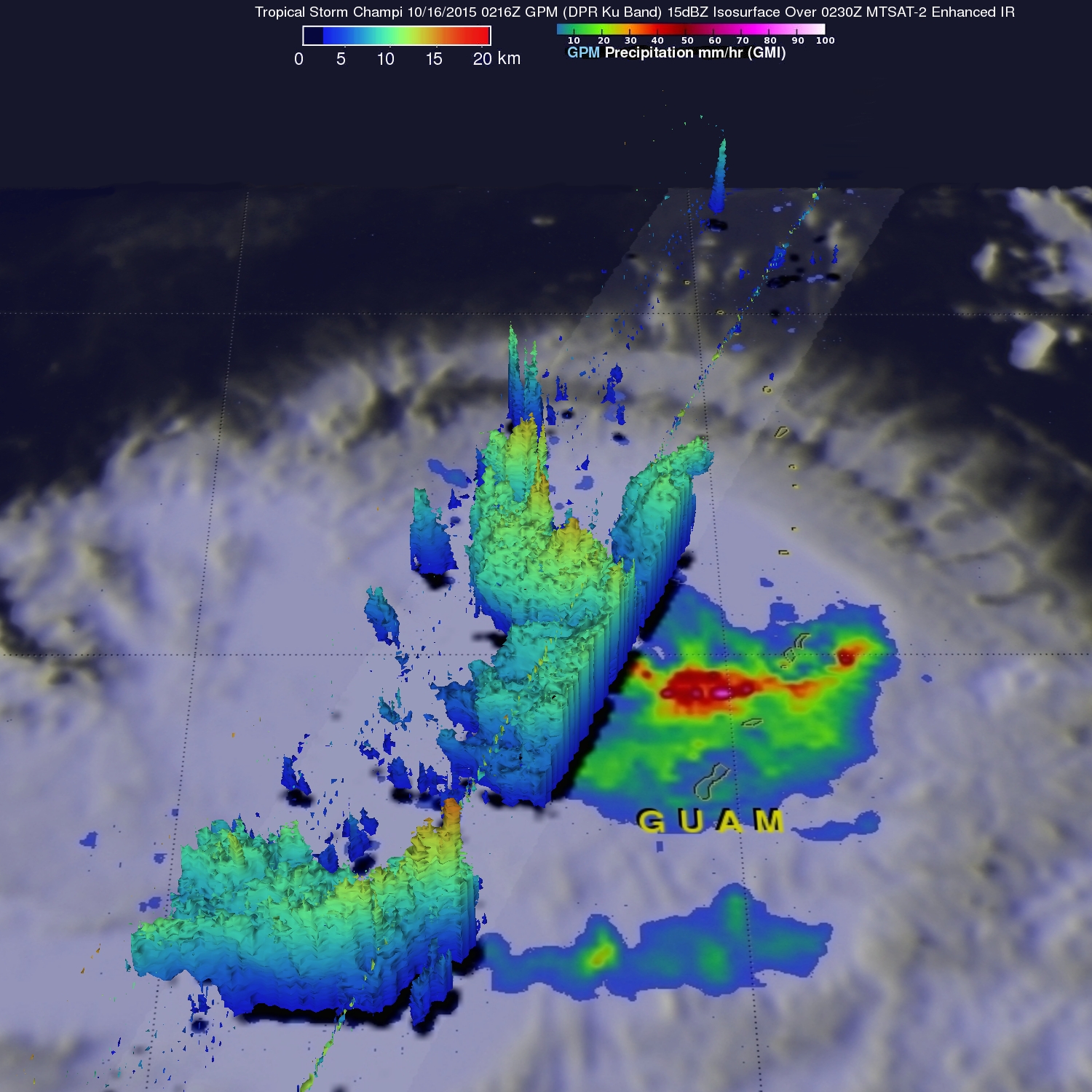
The Joint Typhoon Warning Center (JTWC) determined that Tropical Storm Champi had reached typhoon status with winds of 65 knots (74.8 mph) about 10 hours after GPM collected data with that pass.
The next day, the RapidScat instrument saw Champi’s strongest winds in Champi’s northern quadrant on Oct. 17 at 1300 UTC (9 a.m. EDT). Strongest winds were near 40 meters per second (89.4 mph/144 kph). Typhoon force winds also circled the center of Champi’s eye, but were not as strong as those in the northern quadrant.
On Oct. 19 at 12:29 a.m. EDT, the Atmospheric Infrared Sounder, or AIRS, instrument that flies aboard NASA’s Aqua satellite captured temperature data on the typhoon’s clouds. Cloud top temperatures exceeded the threshold of -63F/-53C, which indicates powerful storms stretching high in the troposphere with the capability to continue dropping the heavy rainfall GPM saw three days before. The strongest thunderstorms were south of the center, while north of the center, sinking air was eroding developing storms. Infrared data also showed that Champi’s eye was 24 nautical miles (27.6 miles/44.4 km) in diameter.
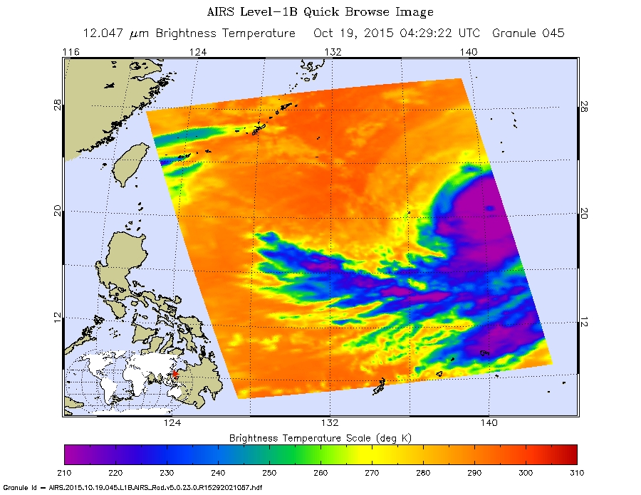
At 1500 UTC (11 a.m. EDT) on Oct. 19, Champi’s maximum sustained winds were near 100 knots (115 mph/185 kph). Champi was centered near 21.1 North latitude and 140.1 East longitude, about 236 nautical miles (271 miles/437 km) south-southwest of Iwo To island, Japan. Champi has tracked north-northwestward at just 2 knots (2.3 mph/3.7 kph) and is generating very rough seas at 10.9 meters (36 feet).
For the latest updates on Iwo To warnings and watches from the Japan Meteorological Agency, visit: http://www.jma.go.jp/en/typh/.
Joint Typhoon Warning Center noted on Oct. 19 that the total precipitable water (animation) loop shows dry air beginning to wrap into the western edge of the circulation, elongating the cloud system structure.
The JTWC forecast calls for Champi to continue a slow crawl north and make a very close approach Iwo To on Oct. 22, while turning to the northeast. Champi is forecast to weaken as it moves over cooler waters, and continues to be affected by dry air moving into the system.
Rob Gutro
NASA’s Goddard Space Flight Center, Greenbelt, Md.
Oct. 16, 2015 – NASA-NOAA’s Suomi NPP Satellite Sees Tropical Storm Champi Affecting Guam
Tropical Storm Champi was over Guam and the Marianas Islands when NASA-NOAA’s Suomi NPP satellite captured a visible image of the storm. On October 16, Champi was moving farther away from Saipan and Tinian in a westerly direction.
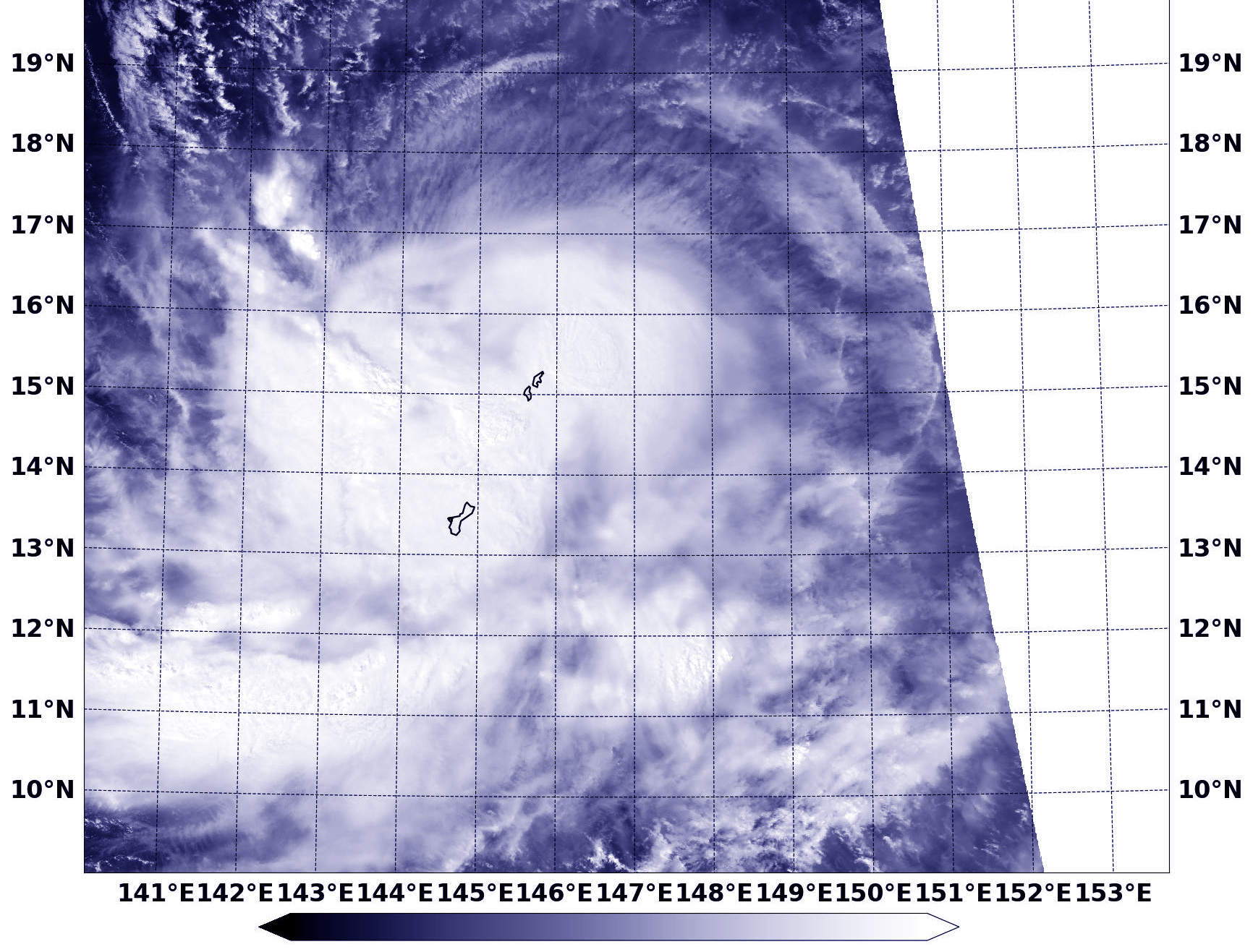
The Visible Infrared Imaging Radiometer Suite (VIIRS) instrument aboard NASA-NOAA’s Suomi NPP satellite saw Tropical Storm Champi on October 16 at 0409 (12:09 a.m. EDT). The visible-light VIIRS image showed strongest thunderstorms associated with the tropical cyclone were in the storm’s western quadrant and over Guam. Guam is a U.S. island territory in Micronesia, in the Western Pacific.
On October 16, 2015 at 5 a.m. EDT/0900 UTC, the center of Tropical Storm Champi was located near latitude 15.8 north and longitude 144.7 west. The storm is about 127 nautical miles (146 miles/235 km) north of Saipan and moving west at 17 knots (19.5 mph/31.4 kph). Maximum sustained winds were near 60 knots (69 mph/111 kph).
The National Weather Service in Guam continued its tropical storm warning for Rota, Tinian and Saipan. For updated forecasts for Guam, visit the National Weather Service website: http://www.prh.noaa.gov/pr/guam/.
The Joint Typhoon Warning Center forecast calls for Champi to move in a west-northwesterly direction and curve to the north-northeast and then northeast by October 20, taking it just east of the island of Iwo To, Japan.
Rob Gutro
NASA’s Goddard Space Flight Center
Oct. 15, 2015 – NASA-NOAA’s Suomi NPP Satellite Sees Tropical Storm Champi Near Northern Marianas Islands
NASA-NOAA’s Suomi NPP satellite spotted Tropical Storm Champi dealing with wind shear in the Northwestern Pacific Ocean. A Tropical Storm Warning is currently in effect for the Commonwealth of the Northern Mariana Islands.
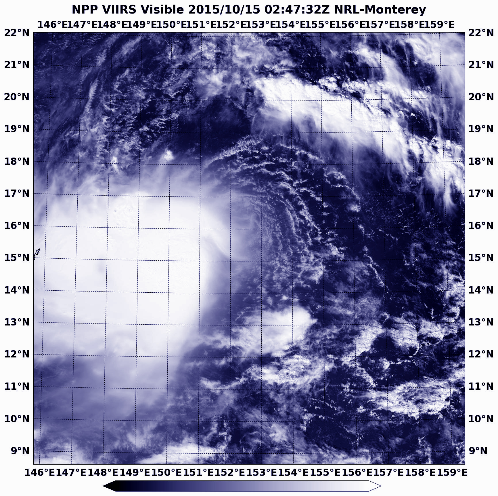
The Visible Infrared Imaging Radiometer Suite (VIIRS) instrument aboard NASA-NOAA’s Suomi NPP satellite saw Tropical Storm Champi on October 15 at 0247 (Oct. 14 at 10:47 p.m. EDT). The visible-light VIIRS image showed strongest thunderstorms associated with the tropical cyclone were located east-southeast of the low-level center of circulation. The storm was being affected by northeasterly vertical wind shear near 20 knots (23 mph/37 kph).
On October 15, 2015 at 11 a.m. EDT/1500 UTC, the center of Tropical Storm Champi was located near latitude 16.0 north and longitude 148.8 west. The storm is about 218 nautical miles (250.9 miles/403.7 km) northeast of Saipan and moving west at 16 knots (18.4 mph/29.6 kph). Maximum sustained winds were near 50 knots (57.5 mph/92.6 kph). The National Weather Service in Guam noted that satellite data indicate that tropical storm force winds extend outward up to 150 miles south of the center and up to 115 miles north of the center.
The National Weather Service in Guam has issued a tropical storm warning for Rota, Tinian, Saipan, Alamagan, Pagan and Agrihan. In addition, a typhoon watch was in effect for Agrihan, Pagan and Alamagan. For updated forecasts for Guam, visit the National Weather Service website: http://www.prh.noaa.gov/pr/guam/.
The Joint Typhoon Warning Center forecast calls for Champi to pass to the north of Guam on October 16 and curve to the north-northeast and then northeast by October 20, taking it away from Japan.
Rob Gutro
NASA’s Goddard Space Flight Center
Oct. 14, 2015 – GPM Sees Heavy Rainfall in Intensifying Tropical Depression Champi
The Global Precipitation Measurement (GPM) mission core satellite found moderate to heavy rainfall occurring in Tropical Depression Champi before it strengthened into a tropical storm.
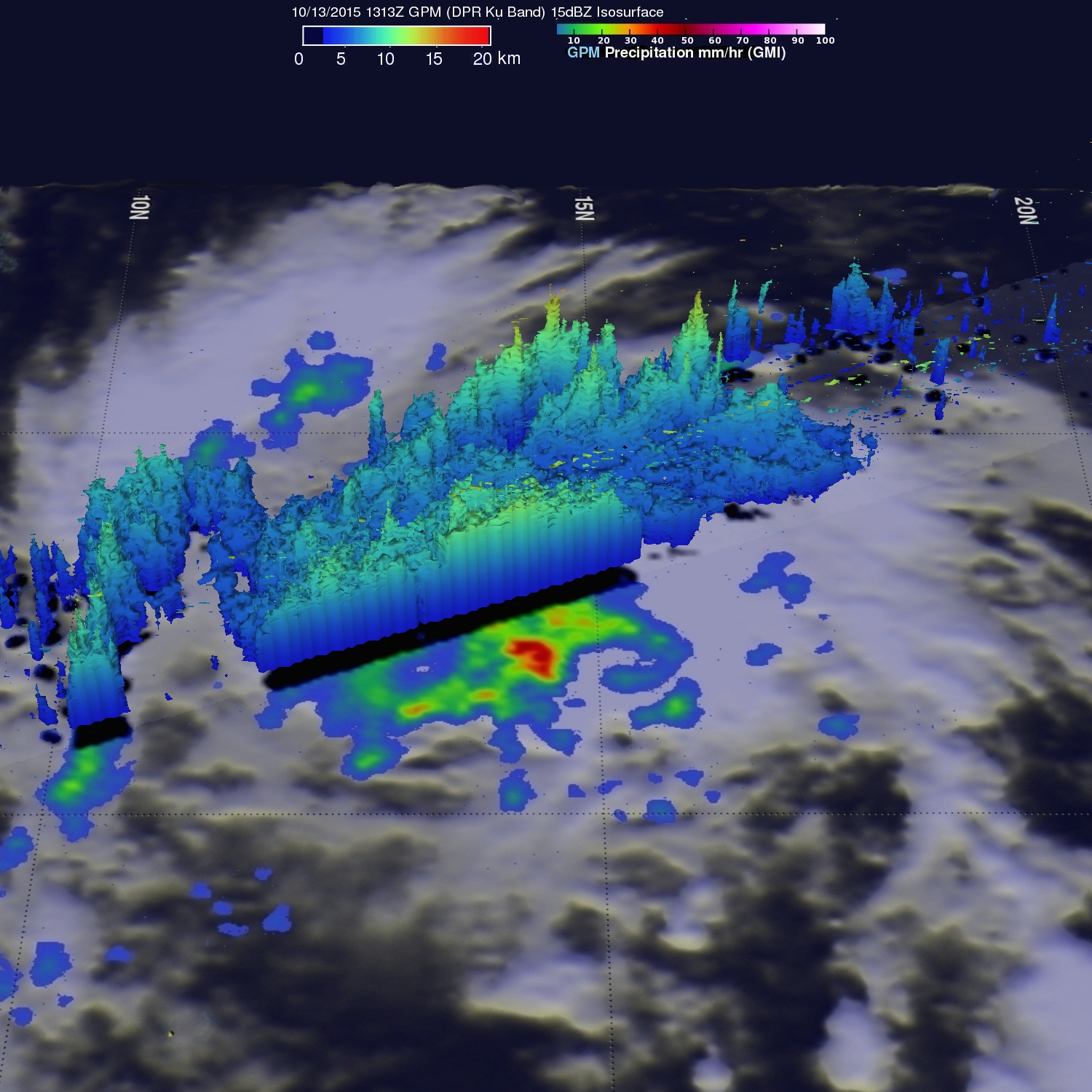
Tropical Depression Twenty Five (TD25W) formed on Tuesday, October 13 east of Guam. The GPM core observatory satellite saw TD25W on October 13, 2015 at 1313 UTC (9:13 a.m. EDT) and found moderate to heavy rainfall falling at a rate of up to 67 mm (2.6 inches) per hour.
At NASA’s Goddard Space Flight Center in Greenbelt, Maryland a 3-D image was made using GPM’s Dual-Frequency Precipitation Radar (DPR) data where the Ku Band data sliced through the western side of the tropical depression.
By October 14 at 0900 UTC (5 a.m. EDT), Tropical Depression 25W had strengthened into a tropical storm and was renamed Tropical Storm Champi. At that time, Champi was centered near 14.9 North latitude and 156.4 East longitude, about 614 nautical miles (706.6 miles/1,137 km) east of Saipan. Champi was moving to the west-northwest at 20 knots (23 mph/37 kph). Maximum sustained winds were near 35 knots (40 mph/64 kph).
The Joint Typhoon Warning Center forecast calls for Champi to move west-northwest and pass to the north of Guam. After passing Guam it is expected to peak in intensity near 110 knots (126.6 mph/203.7 kph) on October 18.
Harold F. Pierce
SSAI/ NASA Goddard Space Flight Center
Oct. 13, 2015 – NASA-NOAA’s Suomi NPP Spots Twenty-Fifth Tropical Depression in Northwestern Pacific
2015 has been an active year for tropical cyclones in the northwestern Pacific Ocean as NASA-NOAA’s Suomi NPP satellite spotted the twenty-fifth tropical depression.
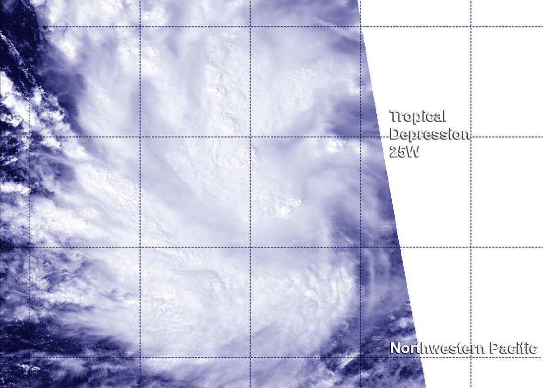
Visible data from the Visible Infrared Imaging Radiometer Suite (VIIRS) instrument aboard NASA-NOAA’s Suomi NPP satellite saw Tropical Depression 25W on October 13 at 0325 (Oct. 12 at 11:25 p.m. EDT). The VIIRS image showed thunderstorms wrapped around the low-level center of circulation and in a band to the south of the center.
The Joint Typhoon Warning Center analyzed an image of rainfall from NASA/JAXA’s Global Precipitation Measurement or GPM core satellite from 1311 UTC (9:11 a.m. EDT) on October 13, 2015 and the microwave image showed a better defined low-level center and curved bands of thunderstorms along the western quadrant of the storm.
On October 13, 2015 at 11 a.m. EDT/1500 UTC, the center of Tropical Depression 25W (TD25W) was located near latitude 13.1 north and longitude 158.8 west. The storm is about 842 nautical miles (969 miles/1,559 km) east of Andersen Air Force Base, Guam, and moving west at 16 knots (18.4 mph/29.6 kph). Maximum sustained winds were near 25 knots (28.7 mph/46.3 kph). The Joint Typhoon Warning Center expects the depression to strengthen into a tropical storm by October 16 at which time it would be re-named Champi.
For updated forecasts for Guam, visit the National Weather Service website: http://www.prh.noaa.gov/pr/guam/.
The Joint Typhoon Warning Center forecast takes TD25W to the west-northwest north of Guam by October 16.