Lee esta historia en español aquí.
On Earth Day, people focus on the well-being of our planet, including how humans are affecting its climate. Every day of the year, the International Space Station, orbiting 250 miles above Earth, provides a wealth of data that helps with that focus.
The station is one of dozens of NASA Earth missions in orbit and provides three main platforms for studying climate change: multiple Earth-observing instruments mounted on its exterior, a platform for deploying Earth-observing CubeSats, and windows that astronauts use to take photos of the planet. Because its orbit passes over 90 percent of Earth’s population and circles the planet 16 times each day, the astronauts and instruments have views of multiple locations at different times of day and night.
Scientists need to track the factors influencing climate over long periods, and the space station helps them do so. Its contributions, along with those from NASA’s Applied Sciences Program, are informing climate decisions and helping humans understand and care for the planet and solve challenges created by climate change.
Eyes on Earth
Some of the current investigations using instruments on the exterior of the space station to collect climate-related data include ECOSTRESS, EMIT, and SAGE III-ISS.
ECOSTRESS
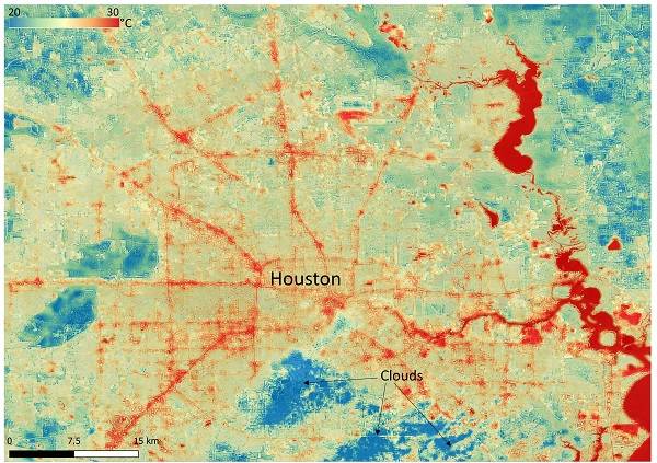
ECOSTRESS measures the temperature of the ground, which is hotter during the day than the air. This image of Houston, Texas in June 2022 shows temperature differences between urban surfaces, especially pavement, and cooler suburban areas.
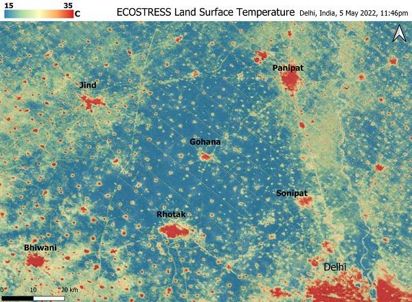
During a heat wave in India and Pakistan in May 2022, ECOSTRESS clearly delineated urban “heat islands” that had night temperatures as high as 102 degrees Fahrenheit while nearby rural fields had cooled to about 60 F. Urban heat experts note that extreme temperatures can be deadly due to this urban heat island effect, a risk that is compounded when temperatures do not drop sufficiently at night.
EMIT
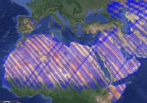
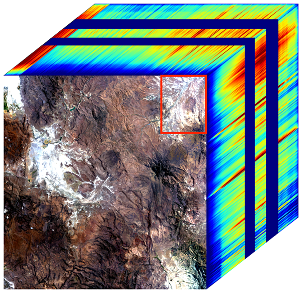
Scientists are using maps created by EMIT’s imaging spectrometer, including these of regions of the Sahara Desert (top) and Nevada (bottom), to assess how dust particles affect the climate. When these particles are lifted into the atmosphere by wind, they can have heating or cooling effects, depending on their composition. The red box in the image from Nevada shows the presence of a light-colored clay mineral that reflects sunlight.
“Darker colors absorb sunlight and lighter colors reflect it, so the color of dust affects the temperature,” says Kate Calvin, chief scientist and senior climate advisor at NASA.
EMIT also identified more than 50 super-emitters, infrastructure that emits methane at high rates. Methane is a potent greenhouse gas, and limiting its emission is key to limiting climate change.
SAGE III-ISS
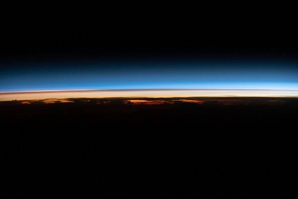
The thin dark layer below the blue stratosphere in this image taken in March 2022 by SAGE III-ISS contains particles from the Hunga Tonga-Hunga Ha’apa volcanic eruption a few months earlier. This instrument measures these tiny particles or aerosols from volcanoes and wildfires, which can remain in the upper atmosphere for years, affecting climate around the globe by scattering light from the Sun.
The instrument takes measurements of light from the Sun or Moon as it passes through Earth’s atmosphere at the edge, or limb, of the planet, called occulation. As of March 2023, SAGE III-ISS has collected more than 54,000 occultation events, the vast majority of them solar.
Other investigations on the space station also contribute to climate science, including GEDI, OCO-3, DESIS, TSIS (also known as TSIS-1), and HISUI.
Images from Above
Crew members have taken more than 3.5 million images of Earth from the space station for Crew Earth Observations, one of the longest running records of how our planet changes over time. This program currently supports a number of studies, including of surface features such as lakes, glaciers, and volcanoes, and atmospheric processes affected by volcanic eruptions.
These photographs record growth and decline at the Toshka Lakes in southern Egypt from extreme weather events between Sept. 2002 and Nov. 2021. The lakes are natural depressions in the Sahara Desert filled by water diverted from Lake Nasser, a reservoir on the Nile River, and their water levels fluctuate depending on the flow of the river. The lakes, full in 2002 (left image) after several years of high floods, had mostly dried up by 2012 (middle image). The lakes shrank further in 2017 and 2018, then experienced rapid filling after record-breaking floods in Sudan in 2020 and 2021. The November 2021 photo (right) shows the lakes at their highest level ever, with new lakes that formed in depressions to the north and south of the eastern basin. The Toshka Lakes project was designed to provide irrigation for agricultural development and attract people away from the dense populations of the Nile Valley.
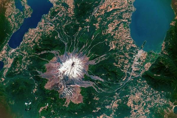
Chile’s Villarrica volcano emits plumes of steam and volcanic gases after a series of minor explosions in this photo taken from the space station on Jan. 17, 2023. A streak of ash is visible on the snow-covered volcano (bottom of photo). This type of low-level activity can be one indicator of imminent volcanic activity. Villarrica is one of South America’s most active volcanoes and one of the most dangerous in the southern Andes volcanic zone.
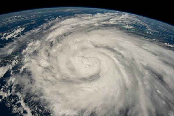
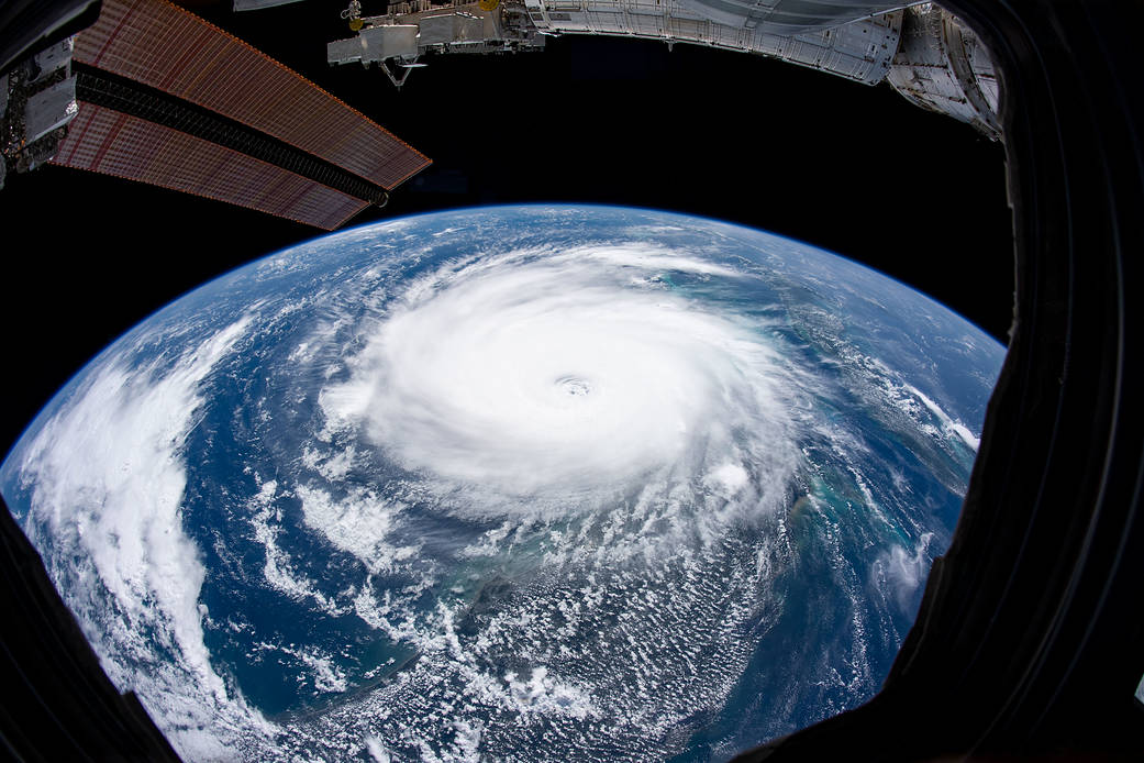
In this image taken from the space station on Sept. 26, 2022, Hurricane Ian spins just south of Cuba before heading toward Florida. Ian made landfall near Punta Gorda, FL, as a Category 4 storm on September 28. It ranks as the third most-costly U.S. hurricane on record, causing nearly $113 billion dollars in damage and 152 deaths. Studies show that climate change creates conditions leading to more rapid intensification of such storms.
Science from Small Satellites
CubeSats are small, box-shaped containers approximately used for technology demonstrations or tests of new types of climate science deployed from the station airlock.
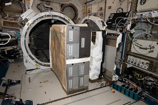
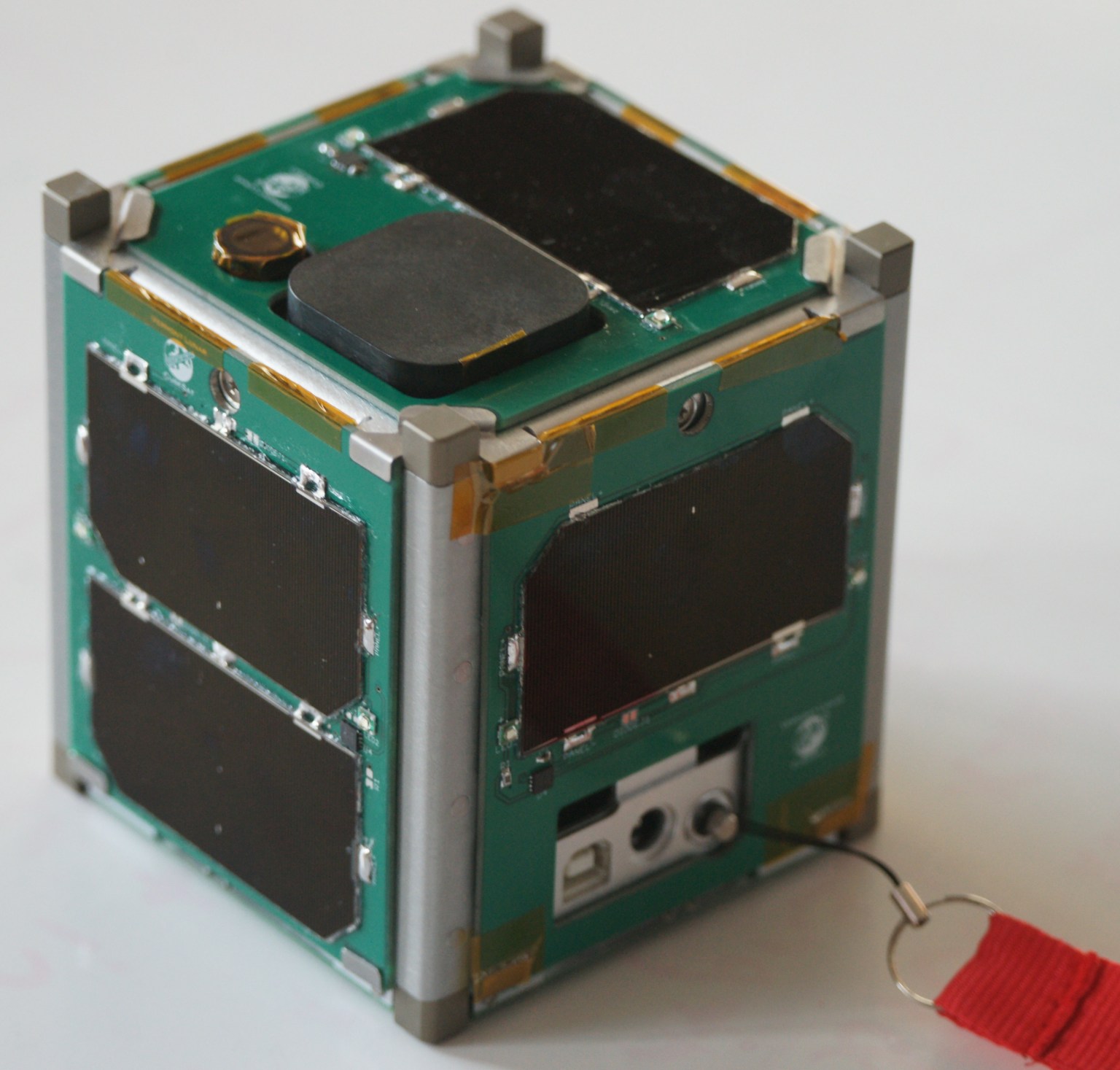
NASA’s HARP CubeSat, shown ready for deployment from the space station, demonstrated that these small satellites could carry a compact imaging polarimeter, an instrument that observes how light scatters off particles to determine their size, shape, and chemical composition. Interactions between these particles and clouds are an area of significant uncertainty in climate models and HARP could help reduce that uncertainty. After 777 days in space, HARP successfully ended its mission, which pioneered new technologies for observing cloud and aerosol properties from space – crucial for learning more about Earth phenomena like air pollution and climate change.
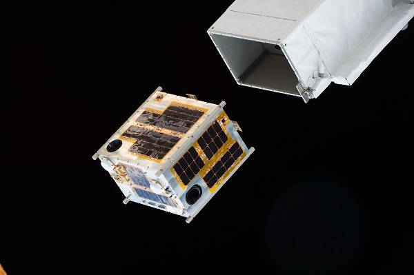
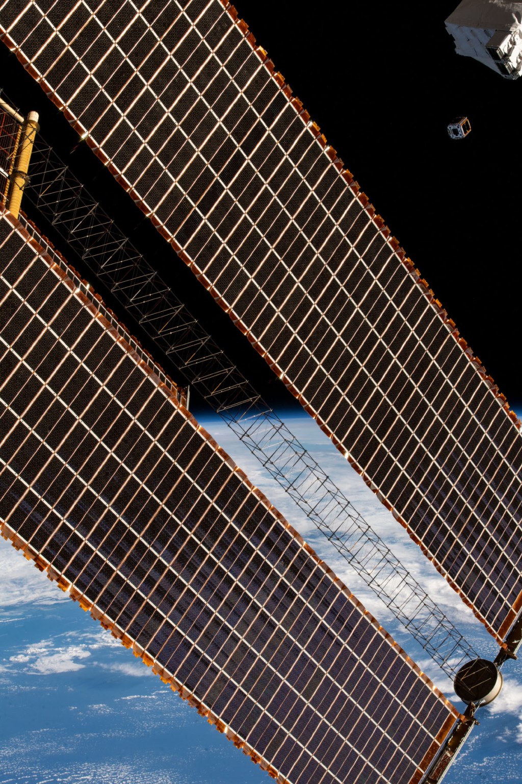
This image shows deployment of JAXA’s (Japan Aerospace Exploration Agency) DIWATA-1 CubeSat, which observes meteorological disasters such as typhoons and localized heavy rains for the Philippines.
During its nearly 23 years in orbit, the space station has evolved into an important part of NASA’s work to study Earth’s climate and improve our understanding of how it is changing.
Melissa Gaskill
International Space Station Program Science Office
Johnson Space Center

