


NISAR will study changes to ice sheets, glaciers, and sea ice in fine detail, as climate change warms the air and ocean.
NISAR, the soon-to-launch radar satellite from NASA and the Indian Space Research Organisation (ISRO), will measure some key Earth vital signs, from the health of wetlands to ground deformation by volcanoes to the dynamics of land and sea ice.
This last capability will help researchers decipher how small-scale processes can cause monumental changes in the ice sheets covering Antarctica and Greenland, as well as on mountain glaciers and sea ice around the world.
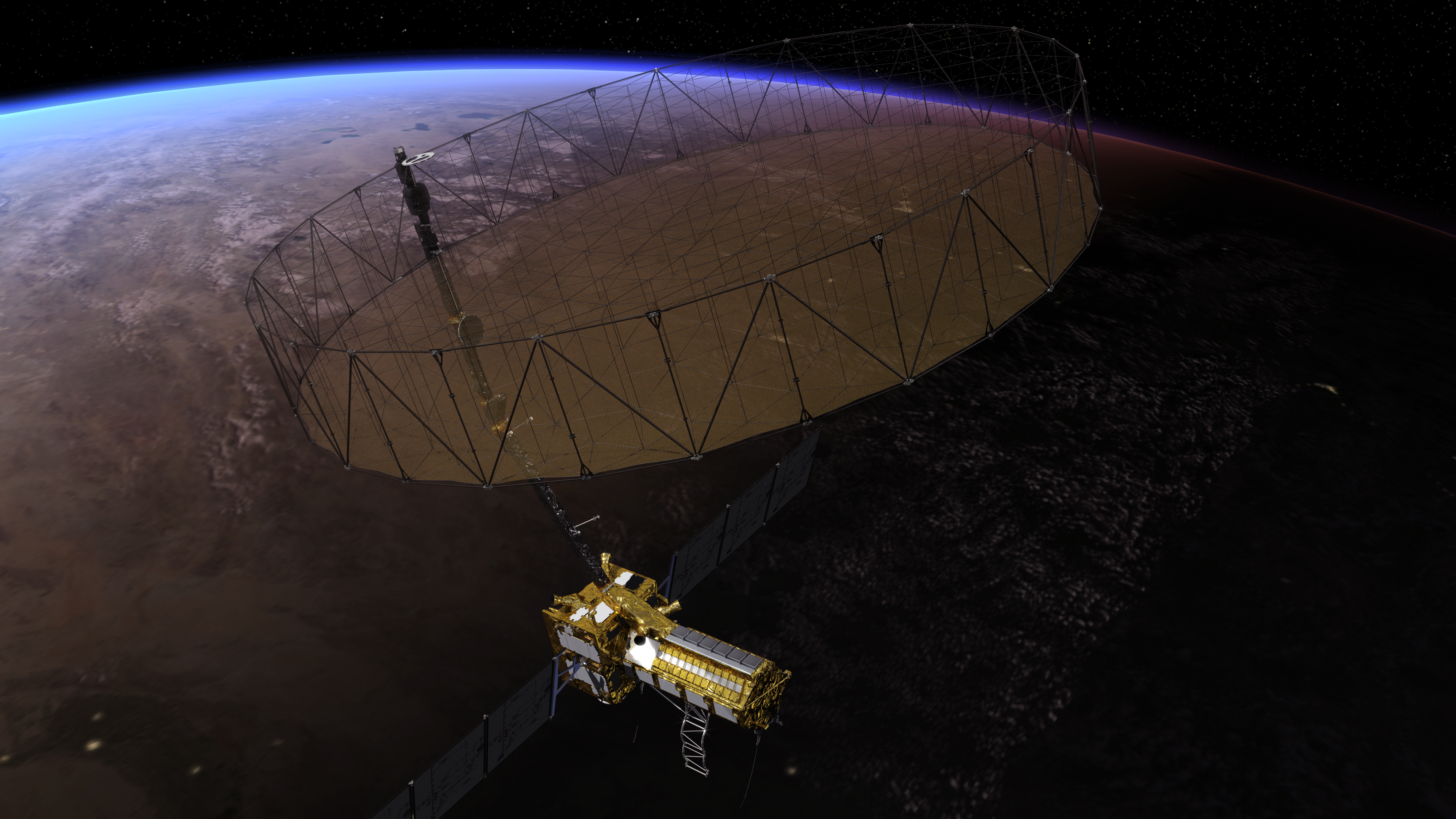
Short for NASA-ISRO Synthetic Aperture Radar, NISAR will provide the most comprehensive picture to date of motion and deformation of frozen surfaces in Earth’s ice- and snow-covered environments, collectively known as the cryosphere.
“Our planet has the thermostat set on high, and Earth’s ice is responding by speeding up its motion and melting faster,” said Alex Gardner, a glaciologist at NASA’s Jet Propulsion Laboratory in Southern California. “We need to better understand the processes at play, and NISAR will provide measurements to do that.”
Set to be launched in 2024 by ISRO from southern India, NISAR will observe nearly all the planet’s land and ice surfaces twice every 12 days. The satellite’s unique insights into Earth’s cryosphere will come from the combined use of two radars: an L-band system with a 10-inch (25-centimeter) wavelength and an S-band system with a 4-inch (10-centimeter) wavelength.
L-band can see through snow, helping scientists better track the motion of ice underneath, while S-band is more sensitive to snow moisture, which indicates melting. Both signals penetrate clouds and darkness, enabling observations during monthslong polar winter nights.
‘Time-Lapse Movie’ of Ice Sheets
NISAR’s orientation in orbit will enable it to collect data from Antarctica’s far interior, close to the South Pole – unlike other large imaging radar satellites, which have more extensively covered the Arctic.
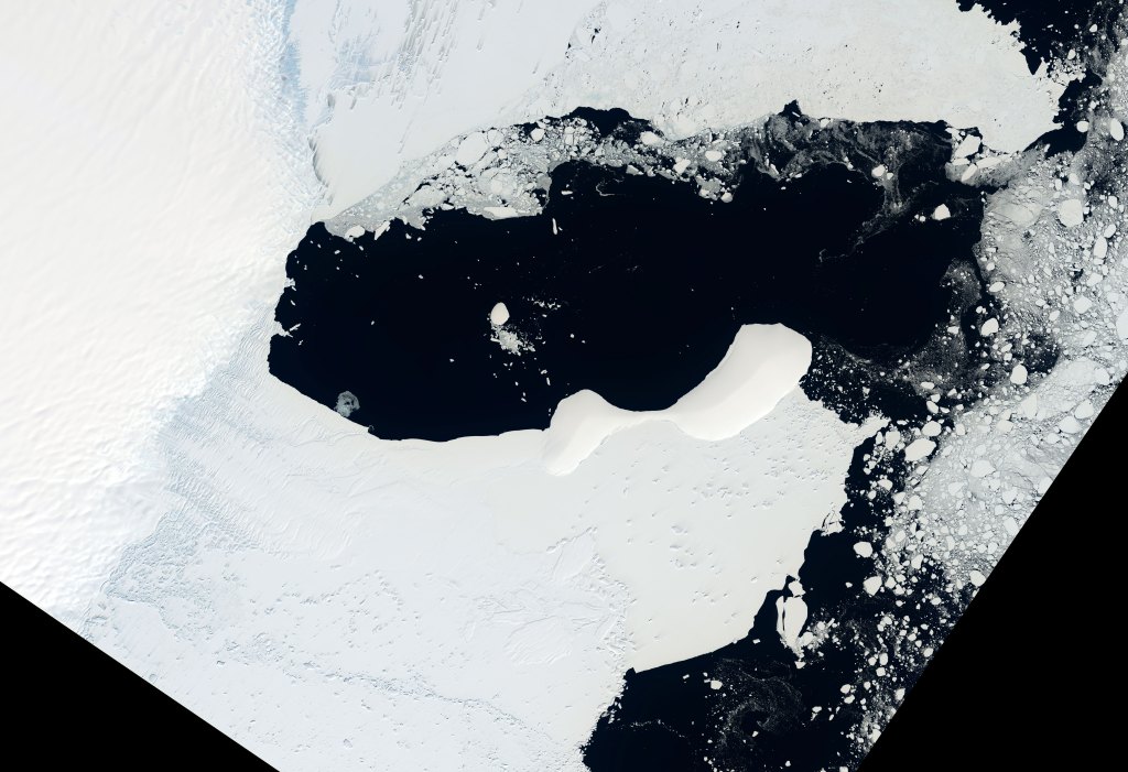
Antarctica’s ice sheets hold the planet’s largest reservoir of frozen fresh water, and the rate at which it may lose ice represents the greatest uncertainty in sea level rise projections. NISAR’s increased coverage will be crucial for studying the motion of ice flowing down from central Antarctica’s high elevations toward the sea.
The measurements will also enable scientists to closely study what happens where ice and ocean meet. For example, when parts of an ice sheet sit on ground that is below sea level, saltwater can seep under the ice and increase melting and instability. Both Antarctica and Greenland also have ice shelves – masses of ice that extend from land and float on the ocean – that are thinning and crumbling as icebergs break off. Ice shelves help keep glacial ice on the land from slipping into the ocean. If they are diminished, glaciers can flow and calve faster.
Ice losses on both Antarctica and Greenland have accelerated since the 1990s, and there’s uncertainty about how quickly each will continue to recede. NISAR will improve our horizontal and vertical views of these changes.
“NISAR will give us a consistent time-lapse movie of that motion, so we can understand how and why it’s changing and better predict how it will change into the future,” said Ian Joughin, a glaciologist at the University of Washington in Seattle and the NISAR cryosphere lead.
Mountain Glaciers, Water Supply, and Flooding
The satellite will also track changes in Earth’s mountain glaciers. Their melting has contributed about a third of the sea level rise seen since the 1960s, and climate-driven changes to freezing and thawing patterns can affect the water supplies of downstream populations.
In the Himalayas, NISAR’s all-weather capability will help researchers monitor how much water is stored in glacial lakes, which is essential to assessing the risk of catastrophic floods.
“The beauty and the difficulty of the Himalayas are the clouds,” said Sushil Kumar Singh, a glaciologist at the ISRO Space Applications Centre in Ahmedabad, India. “With NISAR we will be able to get a more continuous and complete data set that would not be possible with instruments that use visible light.”
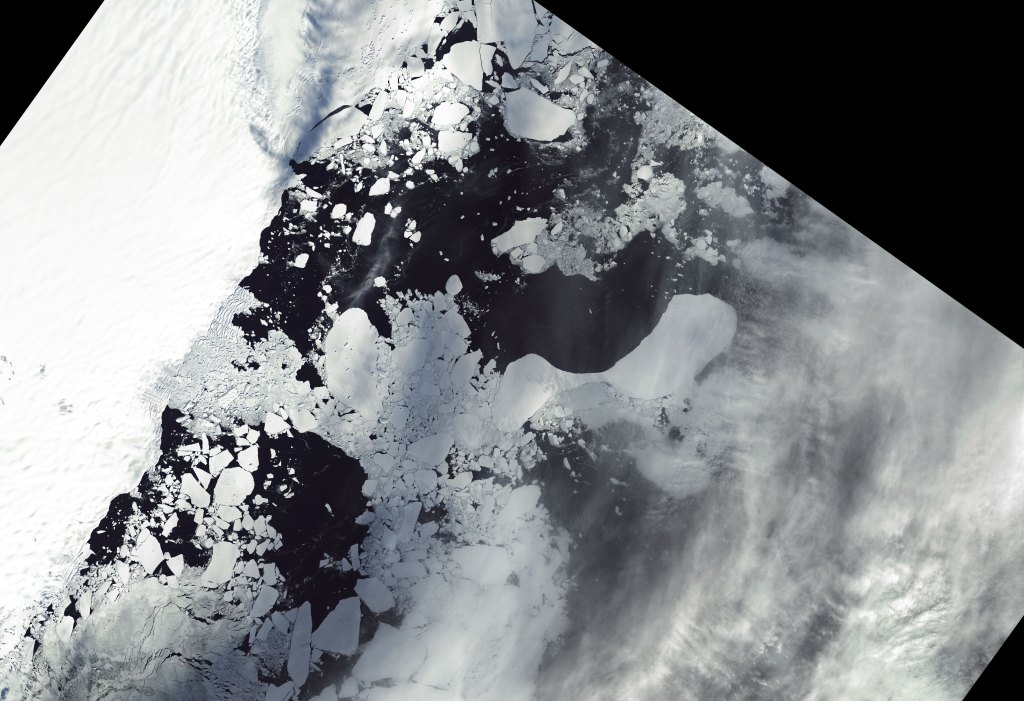
Sea Ice Dynamics Near Both Poles
NISAR will also capture the movement and extent of sea ice in both hemispheres. Sea ice insulates the ocean from the air, reducing evaporation and heat loss to the atmosphere. It also reflects sunlight, keeping the planet cool through the albedo effect.
Arctic sea ice has been diminishing for decades as rising water and air temperatures have increased melting. With more of its surface exposed to sunlight, the Arctic Ocean gains and holds more heat in summer and takes longer to cool. This means less ice formation in winter and faster melting the next summer, said Ben Holt, a JPL sea-ice scientist.
With greater coverage of the Southern Ocean than any radar mission to date, NISAR will open new insights around Antarctica, where sea ice had mostly been more stable until the past few years. It reached a record low in 2023.
More About the Mission
NISAR is an equal collaboration between NASA and ISRO and marks the first time the two agencies have cooperated on hardware development for an Earth-observing mission. NASA’s Jet Propulsion Laboratory, which is managed for the agency by Caltech in Pasadena, California, leads the U.S. component of the project and is providing the mission’s L-band SAR. NASA is also providing the radar reflector antenna, the deployable boom, a high-rate communication subsystem for science data, GPS receivers, a solid-state recorder, and payload data subsystem. U R Rao Satellite Centre (URSC) in Bengaluru, which leads the ISRO component of the mission, is providing the spacecraft bus, the launch vehicle, and associated launch services and satellite mission operations. ISRO’s Space Applications Centre in Ahmedabad is providing the S-band SAR electronics.
To learn more about NISAR, visit:
News Media Contacts
Andrew Wang / Jane J. Lee
Jet Propulsion Laboratory, Pasadena, Calif.
626-379-6874 / 818-354-0307
andrew.wang@jpl.nasa.gov / jane.j.lee@jpl.nasa.gov
2024-001