


If you’re fascinated by the idea of humans traveling through space and curious about how that all works, you’ve come to the right place.
“Houston We Have a Podcast” is the official podcast of the NASA Johnson Space Center from Houston, Texas, home for NASA’s astronauts and Mission Control Center. Listen to the brightest minds of America’s space agency – astronauts, engineers, scientists and program leaders – discuss exciting topics in engineering, science and technology, sharing their personal stories and expertise on every aspect of human spaceflight. Learn more about how the work being done will help send humans forward to the Moon and on to Mars in the Artemis program.
On Episode 141, Dr. William Stefanov, manager of the Exploration Science Office at NASA’s Johnson Space Center, shares his expertise in observing the third rock from the sun on this Earth Day 50th anniversary episode. This episode was recorded on January 30, 2020.
Plus, check out the latest ScienceCast episode on Earth Observations with Will Stefanov.
Transcript
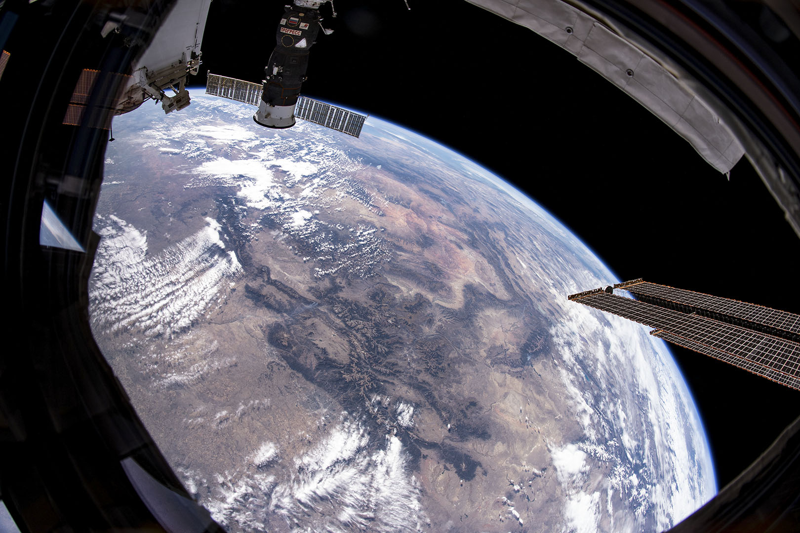
Pat Ryan (Host): Houston, we have a podcast. Welcome to the official podcast of the NASA Johnson Space Center. Episode 141, “The View from Above,” I’m Pat Ryan. On this podcast we talk with scientists, engineers, astronauts and other folks about their part in America’s space exploration program. And today we’re focusing on a very cool science part, honest. When we talk about the science being conducted on the International Space Station, we’re usually talking about something happening in one of the many laboratory facilities inside the station’s modules, the Destiny Lab or the Columbus or Kibo Laboratories. But those are not the only spots where science is done. For instance, last November we spent three episodes, 117, 118 and 119, discussing spacewalks to restore operations of the Alpha Magnetic Spectrometer. It gathers data on cosmic particles from out on the top of the station’s truss pointed out towards space. There are a number of other scientific experiments gathering data from out on the station’s exterior. Many of them are pointed down from a perch 250 miles up. The space station provides a stable platform for scientists who are interested in a different perspective on the home planet. One of those scientists is Dr. William Stefanov, an internationally recognized researcher in remote sensing of urban, geological and ecological processes. He is manager of the Exploration Science Office in the Astromaterials Research and Exploration Science Division located at NASA’s Johnson Space Center in Houston. Stefanov serves as the International Space Station program scientist for Earth observations and at JSC for remote sensing of Earth. Today we’re going to talk about some of those experiments and why they matter, including some experiments that turn out the really outstanding photographs of Earth that have been taken from the station. Be sure to check the episode webpage and the show notes, because there we posted the photos that we’re talking about so that you can see them and follow along. Also, there are links to other sites where you can find other photographs. So, on the occasion of Earth Day, we offer a look at Earth from orbit with Dr. Will Stefanov. Here we go.
[ Music ]
Host: Will Stefanov, you were described to me as the Program Science Officer subject matter in the subjects of ISS remote sensing and Earth science. So, what do we mean by remote sensing and Earth science in this context?
William Stefanov: Well, remote sensing is the discipline and science of collecting information about a material without actually physically contacting it.
Host: The remoteness.
William Stefanov: The remoteness, exactly, exactly. So historically our eyes are basically the first, the primary remote sensing instrument that we have.
Host: Sure, OK.
William Stefanov: We look around our environment and we can tell things. You know, we can tell this is a carpet, this is a chair. You know, you’re a person and I don’t have to actually touch any of that to get that information, because I just happen to know it.
Host: OK.
William Stefanov: And my eyes are transmitting the information that’s coming from light waves, essentially, the electromagnetic spectrum, into my eyes which are capable of seeing a pretty limited amount of the full amount of energy that’s impinging upon us.
Host: You mean of the whole spectrum, right?
William Stefanov: Of the whole spectrum, of the whole spectrum. We only really see a very small part of the visible wavelength, red, green and blue, essentially. And it’s up to our brains to figure out what that information that our eyes are telling us is. And our brains are awesome at that. We are probably still the best remote sensing instrument ever built or developed, I should say, at this point.
Host: Better than the ones humans have built out of stuff laying around.
William Stefanov: In many respects.
Host: Yeah.
William Stefanov: In many respects. But that being said, we have discovered over time that other parts of the electromagnetic spectrum contain information that is very useful to things like figuring out what minerals are on a planetary surface. Or what kind of chemicals are in a plant. Or what kind of stress a plant might be under, what kind of particulates are in the air. What kind of gases are being produced by an erupting volcano. These are all pieces of information that we ourselves can’t natively see, but we can design instruments that can collect that information and then convert it into something that we can see.
Host: We can make machines that “can see” and gather that information from the rest of the spectrum.
William Stefanov: Exactly. Exactly.
Host: And Earth science, is that geology or is it more than that?
William Stefanov: It’s — well, I’m a geologist by training.
Host: And not to demean geology —
William Stefanov: Oh, no, no, no. Oh, you can’t demean geology. But these days geology — some of us prefer geoscience because the discipline has expanded to embrace not just the traditional looking at rocks and minerals but also bringing in what’s the effect of plants on the surface. How does that affect soil development? How does the atmosphere affect how rocks weather and how elements are exchanged between the air, the water and the planetarium materials? So, geology in terms of remote sensing is kind of a natural fit. Because if you’re a classical geologist, you’re trained to do fieldwork. So, you get out there and you walk ridges and you make maps based on what you’re walking over, what you sample, what you look at. And that’s fantastic. That is a critical skill for geologists. But to understand some geologic processes and the broader landscape that you’re walking on, sometimes it’s really difficult to get that sense from just being on the ground. I mean, you can do it, but it takes an awful lot of time and an awful lot of effort. So what remote sensing brings to the table is it gives you that bird’s eye view of the land surface. And when you get up above the land surface and you can see the whole thing, you begin to see patterns in the landscape that are completely evident from the air that are not immediately evident from the ground.
Host: From a wider perspective.
William Stefanov: Exactly, exactly. So, for instance, if you’re looking at how rock beds are tilted or distributed across a landscape, you can get that information if you go and you walk every single ridge and you map all the orientations of the rock beds.
Host: Sounds fun.
William Stefanov: Well, it can be. Depends where you are.
Host: Yeah.
William Stefanov: But if you have a remotely-sensed image of the area where you can see how the beds are lined up and how they extend for hundreds of miles, it can become immediately obvious how the rocks are tilted or folded or how they’ve been affected by earthquake faults or things of that nature. And so, you’ve got that visual component. And then like I mentioned earlier, when you bring in more sophisticated remote sensing technologies to where you can look at things like chemical compositions or mineral identification, now you’ve added the ability to get much more information out of that image for that area than perhaps you as a human being walking by yourself and taking notes in your book can get at. I mean, a good geologist can pick up a rock and identify pretty well what kind of minerals in it and identify what kind of rock it is. But for some rock types that aren’t so obvious, you need chemical information, or you need to know all the minerals in the rock. And that is information that we can now get from remotely sensed data. So, it’s a great tool for enhancing the ability of a geologist to do the work. And this — it’s not just confined to geology. Earth scientists, physical scientists of many disciplines can use remotely sensed data. Like if you’re looking at vegetation patterns, there are sensors that can give you information that is useful for that kind of discipline. There are people who are looking at how disease vectors change over time on the surface, say as areas are heating up or cooling down. That can change the plant distributions and that can change what kind of animals, you know, what kind of prey species, predator species exist in those areas. And some of those predator and prey species are disease vectors. So, by understanding how the land surface is changing, you can then also get an idea of, well, is this area going to be more vulnerable to a particular sort of disease? Less vulnerable? You know, things of that nature.
Host: And that sounds like that’s something that happens over a very long period of time.
William Stefanov: It can.
Host: You’re not seeing those changes in a day or a week.
William Stefanov: Usually not. Usually not.
Host: OK.
William Stefanov: But sometimes if you have an event like let’s say a volcanic eruption or an earthquake or a large storm system comes through.
Host: Yeah.
William Stefanov: Changes the land surface dramatically. That can have equally dramatic changes in things like, oh, suddenly we’re going to have a mosquito outbreak because a hurricane has just come through and now all these areas are flooded. Anything that serves as a little basin, you know, could be a mosquito outbreak.
Host: Standing water where mosquitos can breed.
William Stefanov: Exactly, exactly. And so that’s something where remote sensing can be very useful for, because using the right kind of sensor, you can then create very quickly a map of where all those areas are. And get a better idea of what might happen in the next coming days or weeks.
Host: You mentioned that your background is geology. Fill that in for me, just a little bit and tell us about your professional background. Establish why you understand this, and I don’t.
William Stefanov: OK. I’ve had a pretty twisty career path.
Host: Yeah.
William Stefanov: I started out school in Massachusetts and that’s where I first became interested in rocks. I was like, you know, many kids. I loved dinosaurs and could name every one that was known at that time. But I also had a lot of streams running through my family’s land. And in the streams, you — streams are great because streams sample all the surrounding watershed. And so, you can find a whole bunch of different kind of rocks in the streams. And I just became very interested in, “Oh, what are these different colored rocks? And what do they mean?” And that’s kind of what set me on the path to becoming a geologist. And so, then I moved to Arizona which is paradise for geologists.
Host: Yeah.
William Stefanov: Because there’s, you know, not a lot of those pesky plants on top of things.
Host: Covering up the precious rocks.
William Stefanov: Exactly, exactly. So, you can easily see the rocks. So, I spent the next 15 years living in Arizona getting my graduate degrees and then also getting a job as an environmental consultant. So, I got training not just in the academic side of geology but also in the hands-on, practical — you know, go to this property because we want to sell it and we need to find out what’s on it, kind of geology. From there, then I went, stayed at — that was at Arizona State University. And I stayed there after I got my PhD and then I became interested in ecological remote sensing. Because there was a project there called the Long-Term Ecological Research, Central Arizona, Phoenix site. It’s part of the National Science Foundation.
Host: Yeah, OK.
William Stefanov: And they had established some new sites looking at cities because there was the recognition then that humans are significantly altering the surface of the planet and the best place to find out how humans do that is to look at cities. So, Phoenix and Baltimore were selected as the two parts of this network. And I was at that point with a, you know, shiny new PhD, I became the lead remote sensing scientist for the [Central Arizona Phoenix] [Long Term Ecological Research] CAP LTER project. And there I began to get an interest in not just the hard rock aspects of geology, but sort of the more soft rock aspects. How does the soil interact with the land surface? How does vegetation affect how the geological processes are operating in cities? And what are the environmental hazards associated with cities? From there, then I got an offer to come to JSC to work with the International Space Station program, training astronauts. While that was kind of a departure from what I had been doing, you know, how often do you get an opportunity to come and train astronauts?
Host: Yeah. To do anything.
William Stefanov: Exactly. And also, just to say, you know, “Hey, I actually work on an actual space station.” I’ve always loved science fiction since I was a kid, so that was also like, “Wow, OK, there’s really nothing wrong with this offer.” So off I came to Houston and started working as a contractor for many years. But became involved with the Crew Earth Observations Project which is the group that — since the ISS has been in orbit — they are the ones who have trained astronauts both in taking imagery and also collecting it and archiving it for the public to use. And so, I was brought in due to my geological background and also ecological background as a staff scientist to help train the astronauts in those subjects. And over time I kind of eventually became the chief scientist for Jacobs Engineering, the company I was working for. And then as the ISS became recognized as a useful platform for other remote sensing instruments, then the perceived need to create a position for someone who could really lead a group in that phase of the ISS development.
Host: OK.
William Stefanov: Developing the ISS not just for astronaut photography but for other types of sensors. And I was the successful candidate for that position. And so that’s when I became a federal employee.
Host: Remote sensing for parts of the spectrum beyond the visual part?
William Stefanov: Yes. Yes.
Host: And I want to make that point because we’re going to talk about all of them. But I want to start with the visual. I want to start with the part that you and I and people who are listening to us can see. Crew Earth Observation’s one of my favorite experiments on the space station. Since Expedition one, more than 19 years now, that’s been underway. Give me the thumbnail sketch of what Crew Earth Observations is and what it’s aimed to do.
William Stefanov: Well, it’s actually — it’s the current version of something that astronauts have been doing ever since the Mercury missions. They have always taken cameras up and taken pictures of the Earth.
Host: Of course, they did.
William Stefanov: Because of course, it’s super cool.
Host: You went where and didn’t come back with any pictures?
William Stefanov: Right, right.
Host: Yeah.
William Stefanov: Exactly. And those initial missions, in fact, when we go to Skylab for instance, there was a mission on Skylab that collected some of the initial data that led to robotic sensor systems like Landsat that has been collecting data in various forms since 1972 and has kind of become kind of the workforce robotic remote sensing instrument collecting information about the planet. But originally it was astronaut photography that set the stage for that. So what Crew Earth Observations does is we task the crew to look at a variety of different kinds of targets, science targets, education targets, and these are targets that are submitted by external investigators. For instance, an investigator who’s interested in looking at a particular volcano in South America. So that investigator submits essentially a small proposal to our team. We look at it, verify that this is something an astronaut photography can actually collect data for. And then we set up a target in our system. Every day the Crew Earth Observations team looks at where the ISS is going to be in its orbit for the next 24 hours to see what the crew has the potential to see. Then they filter that information for cloud cover, sun illumination, just verifying that, OK, if the crew takes an image of this, it’ll be a good image.
Host: Not a picture of cloud tops.
William Stefanov: Exactly, not a picture of cloud tops, unless that’s exactly what we’re looking for.
Host: Right, OK.
William Stefanov: So, once we get through all that and then we also look at the crew’s operational schedule to make sure there’s nothing going on that’s going to take their attention, like another experiment or if the ISS is being reboosted in altitude, because that changes where they can see, particularly for small targets. And then we send that up to the crew, so they can see it when they wake up the next day for their next work day. And then it’s up to them to look at when those targets occur and decide whether they can go to a window and take an image. So, it’s not — we are what’s called task listed. So, it’s crew discretion as to whether they have the time and desire to go and take the images that we ask for.
Host: Makes it sound less a mandatory assignment than a wish list or a suggestion. “Hey, if you have time to go take this picture.”
William Stefanov: Exactly, exactly. And we found that most astronauts develop an affinity for doing this. So most of them will make time to go take the images, especially if it’s something super interesting.
Host: Well, we’ve heard — I know I’ve heard from a lot of astronauts who talk about how they get fixated on the view of Earth from that perspective, and they spend a lot of their free time in those windows just looking or taking pictures or shooting videos. And this is an extension of that. You’re giving them specific targets to look at and to try to capture.
William Stefanov: Yeah.
Host: And I want to talk about some of the reasons why in a second. But in the broader sense, we can make that sound really simple. “Hey, go to the window and take a picture.” Do they have to use special cameras to do this?
William Stefanov: No, they don’t.
Host: See, I think that’s kind of remarkable.
William Stefanov: It is.
Host: Just an off the shelf camera, maybe it’s got some long lenses or something. But something that I may have at home in the closet astronauts are using in space to take pictures of Earth with.
William Stefanov: You could absolutely have exactly the same kind of gear that the astronauts use on the ISS in your home.
Host: Cool.
William Stefanov: If you have the same long lenses it’s going to be a lot harder for you to manipulate them in Earth gravity.
Host: Yeah.
William Stefanov: But yes, yeah, it’s all commercial off the shelf equipment. And well, the current make of our cameras is Nikon. You know, I’m not supposed to be plugging.
Host: I asked you what is it, what are they using?
William Stefanov: Right, right. Right, that’s the current brand of camera we’re using. And periodically the photo TV group here will assess what is the best kind of camera, the best kind of commercial off the shelf camera to use. So, it’s not — there have been several different makes of cameras over the years.
Host: And you’re talking about other specialists on the ground here in Houston who are experts on the equipment themselves.
William Stefanov: Yes. Yeah.
Host: They themselves are experts on the equipment.
William Stefanov: Yes.
Host: And these pictures get taken — it could be any time during the astronaut’s work day, or any time between wake up and bedtime?
William Stefanov: Yes, yes. And for some projects, occasionally under special circumstances we can also set up the cameras for timed imagery during their sleep period.
Host: Oh, OK.
William Stefanov: If there’s something that’s particularly of interest. There was a project that just completed called the Tropical Cyclone Project. And that frequently — the crew had to set up the cameras on a timed basis because the cyclones they were interested in passing over happened to be during crew sleep. So that’s a possibility too, but yes, we try to confine the targets to when the crew is actually up. We don’t want them to wake up at, you know, 3:00 in their morning just to go take a picture.
Host: Right.
William Stefanov: But some crew members, if they’re totally motivated, they will ask us to do that for them.
Host: How much time might they spend on this in a day?
William Stefanov: Typically, we allocate approximately a five-minute window for them to go and take the image. Because the ISS is traveling so fast, that’s about all you need to take a specific image and then you’re kind of past where you can take a good shot of it. And we try to limit the amount of targets per day to about three or four. Just one because we realize that this is not a must-do activity to the crew and they have other things to do.
Host: And they probably will get another chance.
William Stefanov: And they probably will. And they do.
Host: In another few days.
William Stefanov: And they do, quite frequently. And sometimes we’ll give them a specific target and for whatever reason they may not go to the window exactly at that time. But they know what the target is, so they see it coming up again in a later orbit and they might take an image of it then.
Host: OK. The reasons why any particular target may be selected have got to vary. Because you said there are a lot of different scientists or researchers who are interested in these targets for many different reasons. Give me a sense of some of the reasons. And I think one of them I’m going to guess — you mentioned a volcano. We’re trying to record historical events, natural events. I’m not sure how to characterize that.
William Stefanov: The answer is yes, all of the above. All of the above.
Host: OK.
William Stefanov: Yeah, so the astronaut photography data set is the longest continual data set of remotely sensed data from orbit that we have. It’s not continuous necessarily in space or time, but in terms of just duration of time covered, it’s one of the longest duration time records that we have. So, some of our sites are continuing to collect imagery of sites that have been looked at from the days of Mercury. For instance, one long-term target that we have is the Toshka lakes in Egypt. And these are lakes that were formed due to an overflow of water from the Aswan Dam when it was created. And these lakes have gone up and down over the years. And you’ve had vegetation forming on the edges and things like that.
Host: Right.
William Stefanov: So, it’s a very interesting environmental record of what happens when you have this human caused activity, this human caused event and how it affects the landscape. There’s numerous glaciers that we’ve been looking at for many years, because those have — most of them have been shrinking over time just as the atmosphere is warming.
Host: And they also move so very slowly that looking at them over a long time would give you a chance to see the movement.
William Stefanov: Exactly.
Host: So to speak.
William Stefanov: Exactly. And we have, as I mentioned earlier, so we’ve got a number of different science requests. Educators are very interested in collecting data for their students. And so, we have a whole separate proposal process for that where schools can send us requests for new imagery if they’re interested in looking at a particular area. And this is something that astronaut photography in particular really excels at. Because it’s intuitively understandable to someone. You know, in some cases it’s similar to you taking a picture out of an airplane.
Host: Yeah.
William Stefanov: You don’t necessarily need to be a remote sensing expert to understand what you’re looking at in the astronaut image. And also, the fact that this is an image that was taken by a human being on a platform orbiting the planet has sort of an intuitive connection to a lot of people.
Host: Yeah.
William Stefanov: That’s different from looking at an image taken by a robotic sensor. You know, just the fact that there was somebody behind the camera.
Host: Somebody with a live finger.
William Stefanov: Somebody with a live finger, exactly. Exactly. And we found that to be very powerful for educational purposes. But right now, right now the highest priority that we have for crew photography is actually disaster response from the International Space Station. Throughout the world there’s an international charter that all countries that have sort of space-based assets have agreed to. It’s colloquially known as the International Disaster Charter. And when something happens, say a volcano erupts or an earthquake occurs, or a cyclone impacts a coastal area, the country that’s impacted can issue essentially what amounts to a call for help, call for data to help them deal with whatever happened in terms of disaster response, aid on the ground. And so, NASA has a program run out of headquarters, the NASA Earth Sciences Disaster Program that —
Host: I’m sorry, the Earth Sciences Disaster Program? OK.
William Stefanov: And JSC participates in that through the ISS program. So, when something happens and it’s something that the crew can see, our group here, CEO team will notify the crew that this event has occurred. We’ll put together a data package that helps them find where the area of interest is and gives them some background on what happened, what kind of data we’re looking for? And then we send that up as a high-priority target to the crew. And if they get data back, it’s downlinked to the ground. Our team here then fully georeferences the data. I should really explain what I mean by that.
Host: What Georeferencing is, yes.
William Stefanov: So, since we’re talking about commercial off the shelf cameras, digital cameras that aren’t — they’re not specifically designed as remote sensing instruments. So, when the astronaut takes a picture of the Earth, there’s no inherent information in that image that tells you exactly where on the surface of the planet that is.
Host: To identify the target.
William Stefanov: To identify the target but also to enable you to drop that image onto say a map of the world, say like in Google Earth or a geographic information system. So, there’s no — the pixels of that image don’t have any geographic information attached to them. So, in the past the way we’ve worked with this is we’ve taken the image, identified the image center point and then by looking at other information that is geographically registered, we can then assign the geographic center point to that image. So at least you have some idea where on the planet this image was from, but when you’re talking about things like disaster response where you want to be able to lay an image down on top of a road network — so you can tell exactly, “Well, these streets are flooded. These houses are impacted. This is exactly where the landslide occurred.” If you don’t have fully georeferenced imagery, you can’t really do that. And so, over the past couple of years we’ve developed a partnership with a group at Ames Research Center to develop a capacity to automatically fully georeferenced astronaut photography.
Host: Ooh.
William Stefanov: So, when it’s downlinked, we know exactly where every pixel in that image is and then you can import it into something like Google Earth and it will lie on top of the surface correctly. And so, it’s greatly enhanced. Primarily it’s used for disaster response.
Host: And I take it then that the usefulness of this is that it gives people in the area where the disaster happened information about — beyond what they can see with their own eyes and where they happen to be.
William Stefanov: Absolutely.
Host: And what needs to be done.
William Stefanov: Yes, exactly. Exactly, correct. And so, once we do all that, then we make that data available to the U.S. geological survey, and they put that into their hazardous data distribution system. They’re the agency that actually delivers data to requesting — to whatever the requesting entity was from another country. So, NASA doesn’t do that directly through that process. And we also send the data to the natural disasters program as well for their use.
Host: OK. Imagery for disaster response. Otherwise, scientists doing research want pictures of stuff?
William Stefanov: Yes. Yes, they do. For a number of different disciplines.
Host: Yeah.
William Stefanov: For instance, there’s been a lot of interest recently in atmospheric processes, things like lightning frequency, things like aurora and also air glow, sky glow on the planet. And there’s actually been several peer-reviewed publications in recent years that have used astronaut photography to get at that kind of information. Because another advantage of the ISS is — besides its particular orbit — it’s also the fact that you have humans who can hold these cameras at essentially any angle. So, the ISS can take imagery, what we call very oblique images. So instead of just looking straight down to where the ISS is, they can look out a window and take a far, sort of a far field image. And that’s perfect for looking at atmospheric phenomena. Because you can pretty much — it would be akin to flying in an airplane and you look out the window and you’re looking at the cloud deck that you’re right next to. And that’s pretty much what the crew imagery —
Host: Seeing it go both above and below where your eye level is.
William Stefanov: Exactly.
Host: That slice of whatever your target is.
William Stefanov: Exactly, exactly. And so that’s another piece of data that has been very useful in recent years to researchers. Another type of data or image that is becoming more and more popular both for general use and also for scientific purposes, is night time imagery. The cameras that we have on the ISS right now are optimized for collecting good night time imagery. So, imagery of cities at night have become very important to a lot of researchers because they’re looking at things like light pollution studies. They’re also looking at how changeovers from traditional or I’d say 20th century lighting like sodium vapor lamps or incandescent lamps are shifting over to LED type lighting solutions. And there are people who are asking, “OK, what’s that kind of light doing to things like nocturnal animals?”
Host: OK.
William Stefanov: You know, is it affecting their patterns? We’re involved in a project with Kennedy Space Center where they’ve changed over all of their site lighting to LED’s and they were interested in how that would affect sea turtle migrations at night. And so, we collected some data for them. I can’t tell you what the results are yet. I haven’t seen them.
Host: Right.
William Stefanov: But that’s something that they’re looking at.
Host: I read too that part of what you can use these for is to document cosmic events. That seems like it’s not stuff on the planet but it’s a planetary transits or meteor showers, things like that?
William Stefanov: Yes. If the situation is correct, like the transit of Venus is something that has been documented by astronauts. Don Pettit when he was up there on one of his missions. He set up cameras in the Cupola so that he could record in a time lapse a series of the transit of Venus across the face of the sun.
Host: Nice.
William Stefanov: And meteors are something that the crew has taken both by accident — we’ve seen sort of serendipitous information. But also, if there’s a big meteor shower, they can set up cameras to take time-lapse imagery and see if they can see meteor events. That kind of brings up another sensor that was on the ISS recently called the meteor sensor. And that was in the WORF, the Window Observation Research Facility. And their whole purpose was to collect, record meteors entering the atmosphere. Because when they burn up, the sensor had a diffraction spectrometer on it. And that was just a way to split the light coming into the camera up into specific wavelengths so that they could get chemical information out of these bursts, these fireballs, if you will. And from that they could tell, get an idea of where that meteor originated from, what kind of parent body in the solar system it originated from. And so that operated quite successfully for a couple of years. And that was pretty much video information that was collected.
Host: Apparently, one source of targets too is a special request from Public Affairs Office. I’ve never made one, but I can imagine that that’s, you know — those people don’t ever go away, right?
William Stefanov: No.
Host: [Laughs] No.
William Stefanov: No, we frequently get requests like that for big events like the Houston rodeo. We’ve had requests, “Hey, can you take pictures of Houston for the rodeo?”
Host: Oh, OK.
William Stefanov: So that we can link it up with social media type accounts. There have been requests for other events that have taken place around the world, say big conferences. We’ve gotten requests for that, “Can you get an image of this to tie into that?”
Host: Of a place so that we can give it to the people who are going to be at that place?
William Stefanov: Exactly, exactly. Exactly. So yeah, those kinds of requests come through not infrequently.
Host: I saw another reason that I found to be really interesting and I want to learn more about it. It says that doing surveys of this planet can fold into helping us do surveys of future places that we will go.
William Stefanov: Yes.
Host: How so?
William Stefanov: Yes. Well, there’s a branch of science that we call analog science. And so, one class of target that we have had in the past for CEO for astronaut photography has been impact craters, meteor impact craters like Barringer Crater in Arizona. Probably a very well-known example. Because we see craters on many other planets a lot more than we see typically here on Earth. Because Earth is a geologically active planet, so it tends to weather its surface and it resurfaces itself on a constant basis. Whereas bodies like the Moon don’t because there’s no active tectonic activity going on. Right.
Host: A footprint that was put there 50 years ago is still there. Yeah.
William Stefanov: Exactly. Exactly. So, by looking at features like that on the Earth, looking at river channels on the Earth, we can then look at the surface of Mars and if we see similar features on the surface of Mars, we can then kind of come to the conclusion that, “Oh, maybe those are also river channels.” And that’s what you do with analog science. You’re looking at features on the Earth that we can find similar features on the planets. And if we understand how the surface, how the feature formed on the Earth, then that gives us a pretty good starting point to figure out what was going on on the other planetary body.
Host: Do you have any idea at all how many photographs have been gathered over — just in the ISS years, in 19-plus years?
William Stefanov: Just for ISS imagery, we’re now over three million images.
Host: Three million individual frames?
William Stefanov: Yes, individual frames. Yes.
Host: Many of these are available for people out there. Anybody who can touch the internet can see lots of them, right?
William Stefanov: Yes, yes. In fact, through our website, The Gateway to Astronaut Photography of Earth, we make that data set available to the public, to the global public. And you can search the entire database. You can download imagery. And you did touch on an important point, that we have over three million images. Only a relatively small fraction of those images have been cataloged. And by cataloged, I mean they have descriptive information added to them to help you search through them. So, for instance, what images are present in this — or what features are present in this image? Like what city, what mountain range, what river? So, something else that we have done over the past several years is we have now brought the techniques of machine learning or artificial neural networks into our group.
Host: Yeah.
William Stefanov: And this is in essence — this is teaching a machine to identify features in the image. And we’ve now started to put some of these on our website, images that have features obtained by machine learning. And these are things like cities. There are now several cities that once you train the machine to recognize what a particular city looks like, we can then run it through, have it look at the entire image catalog.
Host: Wow.
William Stefanov: And tag every image that it finds. So, we’re now opening up a much larger set of images to the public that they can now search on through this technique. And that’s pretty exciting. That’s something that I know myself, I’ve been working to push the group towards for years.
Host: Yeah.
William Stefanov: And it’s exciting to see it actually happening, that we have the technology to actually do that now.
Host: I am aware that people who are listening to the podcast are going, “I would like to see the pictures too, Pat.” Well, we’ve tried to make an arrangement for that. If you’re checking the show notes in the episode pages here, we’ve posted some of the photos that Will, and I are going to look at and he’s going to describe for us right now. And the first one we put up here is one of — I will say a volcano, and I’ll allow you to fill in the difference. But it is a remarkable picture from way above a dust cloud on a volcano.
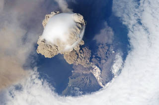
William Stefanov: It is. This is Sarychev Peak in the Kuril Islands. And this is probably my favorite volcano image that the crew has collected, because there’s a lot of stuff going on in it. That big — the big sort of puffy cloud that you see dominating the image.
Host: Right.
William Stefanov: That’s something called a pileus cloud. And that’s formed when the volcano erupted — it pushed a huge mass of air upwards, directly upwards very, very quickly. And when that happens, it condensed all the water that was in that air column right above it.
Host: Just because of the pressure?
William Stefanov: Just because of the pressure and the temperature.
Host: Wow.
William Stefanov: And pushing it up. And so, you get this immediate sort of puffball formation. And it doesn’t last very long. In fact, that cloud dissipated seconds after this image was taken. In fact, if you look at the image, you can begin to see that the erupting material, sort of the ash and steam coming up from below is already starting to kind of penetrate the cloud.
Host: It’s coming through the sides around the circumference.
William Stefanov: Yeah. Now this — pileus clouds have been observed before. This wasn’t like a novel phenomenon. But this was the first time that it had been seen from orbit and captured in this picture. So that by itself is exciting. You also see, if you look at the image, if you look at the volcano itself further down, you see another kind of whitish cloud, if you will, of material.
Host: On the side of the mountain.
William Stefanov: Basically, that’s actually flowing down the side of the mountain. And so that’s what we would call a pyroclastic flow. This is actually one of the most dangerous kinds of eruptions you can have and can basically engulf, you know, whole cities and towns. So, they’re very dangerous. But this island is not heavily populated so there wasn’t that much of a danger. And then the big hole that you see in the image, that actually caused quite a lot of discussion amongst the volcanologic community.
Host: Are you talking about the hole in the cloud?
William Stefanov: The hole in the cloud, yes. So, you’ve got the pileus cloud, you’ve got the island underneath and you’ve got this open space.
Host: I guess I assumed that the eruption and the pileus cloud caused the hole in the cloud.
William Stefanov: That’s one — that’s one possible explanation.
Host: OK.
William Stefanov: Another explanation is that just because of the way wind patterns and the atmosphere acts around these islands during the day, you tend to have conditions set up where the moisture and temperature changes near the volcano itself, near the island, to where clouds don’t form. So, you naturally get this ring of open area around the volcano. And so, there’s are camps that said, “No, that’s what’s going on.” There were camps that said, “No, it’s the eruption that caused the temperature to change around here and that’s why you don’t see any water vapor.” And it’s not clear that there was a winner.
Host: In that debate.
William Stefanov: In that debate, in that debate. I think there’s probably a combination of processes going on in there.
Host: That’s cool. Let’s look at the next one. There’s another natural disaster. But this is — I don’t know, is that a hurricane at night? Or with a spotlight in the middle?
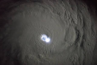
William Stefanov: That is — sort of. This is a shot of Hurricane — of Tropical Cyclone Bansi. And this was taken during darkness, so it was fairly — not complete darkness but getting to be dark. And what you’re seeing is you’re looking right through the center of the cyclone. You’re looking at the eye wall. And you’re seeing thunderstorms and lightning going on inside the eye wall.
Host: Oh, OK.
William Stefanov: And this is also a very, very cool picture because the ISS was pretty much directly over the storm when this was taken. So, you can actually — you can see — you can look right through the storm.
Host: You can see water.
William Stefanov: You can see water. You’re actually looking through the eye of the tropical cyclone. And you’ve got this illumination from lightning flashes going on around it.
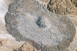
Host: Nice. One more real quick. And I looked at the description of this, so I know what it is, but I couldn’t figure it out on my own looking at it. What is a salt glacier?
William Stefanov: Ah. A salt glacier. That is — well, glaciers, as —
Host: I thought glaciers are ice.
William Stefanov: Glaciers are ice. Yes. And so frozen water and glaciers flow because ice can flow over time. It turns out, salt can do the same thing. Salt is — salt is not just on your table. Salt is a mineral. It’s a naturally occurring form. It’s called halite, sodium chloride. And under the right geologic conditions you can get large volumes of salt being deposited, sort of evaporating lake beds. And over geologic time, those salt layers can then be covered up by other materials, soils, rock, buried under hundreds of miles on the surface. And when that happens, salt has a lower density than the rock that’s above and below it. So, if there’s any — and it wants to flow. It’s not a solid rock. So, if there’s anything that causes the rock above it to have any kind of crack or any weakness —
Host: It can flow through it.
William Stefanov: The salt will push it up.
Host: OK.
William Stefanov: And so, this is a tie-in back to Houston. Because if you look around the eastern Texas area and in the Gulf of Mexico, you see a lot of what are called salt domes. Mont Belvieu is a salt dome. High Island is a salt dome.
Host: The strategic petroleum reserve is there. Yeah.
William Stefanov: Exactly. Exactly. And they’re domes because there’s salt under them that’s pushing them up.
Host: OK.
William Stefanov: Now the salt hasn’t actually come to the surface at this point. It’s like you’re pushing your fist up under a rug or something and you’re doming up the material on top of it. But in this case, in the Zagros Mountains of Iran where this is taken, the salt has actually flowed up through the rock to the surface and extruded itself on the top.
Host: OK.
William Stefanov: Kind of like toothpaste. And so enough of this has come up so through the central salt dome that you see in the middle, that the salt is on the surface and is now sort of flowing downhill if you will.
Host: Is this similar to a volcanic eruption? Stuff comes ups and through?
William Stefanov: It could be. It could be for a particular — yeah, if you have a very, very viscous volcanic eruption.
Host: OK.
William Stefanov: It’s kind of similar.
Host: It helps me visualize what we’re talking about.
William Stefanov: Yeah, yeah.
Host: How it’s working, yeah.
William Stefanov: So, what you’re seeing here in this image is you’re seeing all this salt on the surface and it’s whitest kind of right near the central salt dome. That’s where it’s coming out.
Host: Yes.
William Stefanov: And also, you see it’s very white in these stream channels that have been cut on the side, because that’s exposed. The rest of it looks kind of brown.
Host: Looks like it dried.
William Stefanov: Not so much it dried. That’s all just dust and things that have settled on top of it.
Host: Oh, OK.
William Stefanov: And so just like a glacier that’s flowing downhill, the salt is now flowing downhill as well, and that’s why have all these ridges being formed kind of around the edges. Because that’s being formed as the salt is flowing and sort of separating along the surface. So yeah, this was a serendipitous image. We didn’t ask the crew to collect this, but when I saw it, at first, I had the same reaction. I was like, “Wow, what is that?” And then I educated myself, “Oh, it’s a salt dome and it’s a salt glacier.”
Host: Yeah.
William Stefanov: It’s like, wow, I’ve never seen one so well-developed. But there’s actually several of these in the area.
Host: Cool. There are other experiments on the station that are aimed at the visual part of the spectrum. But I wanted you to talk about some of the other experiments that are not aimed at that. There are instruments on the station that are not taking pretty pictures for me to look at. What other kinds of science data is being gathered in this broad umbrella of Earth observations?
William Stefanov: A pretty wide range of different kind of data sets. The ISS is — it’s now pretty much fully developed as a remote sensing platform in that it can host a wide range of different kind of sensors. You know, we’ve talked about handheld camera imagery. But right now, we have sensors onboard that are hyper-spectral sensors. And by that — we talked earlier about the electromagnetic spectrum and how there’s regions of the electromagnetic spectrum that our eyes can’t see but we can design sensors to look at that. So, what a hyperspectral instrument does is it looks at these different areas of the spectrum, of the electromagnetic spectrum, and collects data at very, very specific wavelengths through that spectral range. And when you do that, you can measure what the reflectance is, or you can think of it also as sort of the power return back to the sensor from the surface in each of these wavelengths. And different materials will have different spectra. Think of it as material fingerprints if you will.
Host: They reflect differently, and you can identify what that is down there by the amount of time it takes for a signal to transit?
William Stefanov: Not so much the amount of time but the degree of, the amount of reflectance it has in a particular wavelength.
Host: OK, in one area of the spectrum.
William Stefanov: Exactly.
Host: OK.
William Stefanov: Exactly. Exactly. And so, when you look at a whole range of these different wavelengths, you can develop a spectral curve. And different materials like certain minerals will have a very strong return in say .9 microns.
Host: Yeah.
William Stefanov: And it will have a very low return in .8 microns. And so, you can look for specific features, and they’re very diagnostic of a particular mineral. So that’s why I mentioned they can serve as fingerprints in a way. When you see these features in the spectrum, you’re pretty sure, “OK, that’s this particular mineral that has that feature.” So, there’s two sensors onboard that have this capability. There’s the [Hyper-Spectral Imager Suite] HISUI instrument which is a Japanese sensor that was a hyperspectral instrument that just went up on SpaceX 19.
Host: OK.
William Stefanov: And then there’s also the [DLR Earth Sensing Imaging Spectrometer] DESIS instrument which is a commercial sensor that’s part of the [Multiple User System for Earth Sensing] MUSES platform. And that looks at imagery from — or it looks at wavelengths from the visible through near-infrared spectrum. So very useful if we’re looking at vegetation, some minerals. And now they’re starting to look at it to see how well we can detect plastics.
Host: Plastics?
William Stefanov: Plastics in the ocean.
Host: Oh, like floating plastic mountains?
William Stefanov: Exactly, exactly. Yeah. I’m sure you’ve heard of the garbage patches in both the Pacific and Atlantic.
Host: Yeah.
William Stefanov: And so, the DESIS team has been looking at their data and they think that they’ve found a way to identify some of these plastics, these plastic garbage patches in their data. They’re still doing research to kind to finalize that and confirm those results, but it’s encouraging stuff. And so, we have those kinds of sensors onboard. We also have what we would all active remote sensing. That’s a LDAR system, a laser system. Light detection and ranging. And that is the GEDI sensor. That’s the Global Ecosystems Dynamics Investigation. And that is a sensor which is a laser pointed at the Earth. And what it’s doing is it’s collecting measurements of the vegetation canopy around the planet, forest cover, vegetation cover. And so that’s the instrument where they’re looking at time to return.
Host: Oh, OK.
William Stefanov: So, the laser is firing at the Earth’s surface and the time that it takes that light to be reflected back up to the sensor is recorded. And the interaction —
Host: You need calculate the distance and know the height of the canopy.
William Stefanov: Exactly. But you could do more with this kind of instrument.
Host: But wait, there’s more.
William Stefanov: But wait, there’s more. By collecting enough data, you can also look at how often the light has bounced around, if you will, before it goes back up to the surface, or back up to the sensor. And so, you can not only just get an idea of the height of the canopy. You can also get an idea of what the structure of the canopy is underneath it.
Host: Wow.
William Stefanov: And that’s what the GEDI team is doing. They’re building this three-dimensional map of this canopy surface. And they’re collecting this data over a couple of years.
Host: At least.
William Stefanov: At least. And the whole purpose of this is to look at how that canopy is changing over time as sort of vegetation patterns are changing. You know, how’s that changing the amount of carbon biomass that we have above the surface? We also have sensors that are looking at the atmosphere. Not so much the ground surface but the atmospheric column above it, like the Orbiting Carbon Observatory 3 which is looking at the exchange of carbon dioxide between the land surface and the atmosphere. And that of course relates directly to things like greenhouse gases and atmospheric warming. And all these sensors — and one other that I should have mentioned is something — another new sensor that we’ve added to the ISS, new capability. There’s also the eco stress instrument which is a thermal infrared or mid-infrared sensor that’s collecting data in those wavelengths, longer wavelengths, essentially 7-13 microns. And what they’re looking at specifically is heat stress in plants. Because in the thermal IR, when you’re looking at a thermal image, quite frequently you’ll be able to see where a plant is overheating as it were before you get a visible indication that the plant has some stress.
Host: I was wondering how you could see stress. Yeah.
William Stefanov: Yeah. Because I mean, anyone who’s failed at having — you know, raising houseplants or things, know that the first thing you see is you see the plant yellowing. And that’s an indication obviously of stress. But in different wavelengths you can see indications of stress long before you see it visibly. And so that’s what the eco stress sensor is looking at. And so, all of these sensors taken together have now produced what you could call an ecological remote sensing suite on the ISS. Because they’re all collecting information that is of interest to ecological researchers and researchers looking at plant biology. Because they’ll refer to different aspects of a plant. The hyperspectral instruments can tell you what the chemical makeup of the plant is. The eco stress can tell you what its health situation is like. And the OCO-3 can give you some idea of how that plant is actually functioning, how well it’s exchanging oxygen and carbon with the atmosphere. And we can do this on a global basis. So, this is what really enables us ecological scientists to really get an idea of how the planet is functioning, breathing if you will.
Host: All these that you’ve just mentioned, this suite, they’re all relatively new. They’re not brand new, but they’ve been on station within the last year or two?
William Stefanov: Yeah. Within the last year or two, yep.
Host: Was it put together with all of that in mind, that these were all complementary or studying complementary areas that they all need to go to, that they all need to go together? Or was that luck?
William Stefanov: It wasn’t complete luck.
Host: OK.
William Stefanov: But it was —
Host: You’ve got to take the luck whenever you can get it.
William Stefanov: Yes, yes, absolutely. Absolutely. I wouldn’t say it was completely planned out as sensors have gone through the NASA proposal process and review process. Certainly, these teams are aware of other sensors going up, and so they could say, “Hey, if we put this sensor up, it can serve as a complimentary data collection to this other sensor that we know is already either on the station or is going up on the station.” But no, to my knowledge there was no pre-existing concerted effort to —
Host: No grand scheme?
William Stefanov: No grand scheme. No grand scheme in place.
Host: It occurred to me, being a not science guy, that you would get more information on the state of the tree canopies or the ground or whatever by being down on the ground and being closer to them in order to gather information. Yet all these instruments are doing that from a distance of 250 miles or so. Is it ideal to be able to observe these things from that distance? Or do those findings complement other data that you can gather?
William Stefanov: They definitely complement. As we kind of talked earlier, you get a bigger picture from orbit. And yes, you’re exactly correct, when you’re on the ground and you’re actually measuring, you know, taking measurements from the tree canopy itself or actually measuring the girth of a tree or something, that’s data that is still fairly difficult to get from our remote sensing instrument. But it’s complementary. The remote sensing data enables you to extend those really detailed measurements that you get on the ground to a wider area. Because you can match — say you’re looking at a particular kind of tree or particular tree species, you can get the measurements that are important for that kind of tree — say it’s a broadleaf tree versus an evergreen. And once you know what those values are, you can look at the remotely sensed data and say, “OK, I know that’s an evergreen forest, so these are the kind of features, the kind of measurements I’m taking from an evergreen forest.” You can then look at the rest of the data collected from other parts of the planet and say, “Oh, that matches an evergreen forest.” So, you can start extending your reach, the reach of your data, essentially. So yeah, the two definitely work together.
Host: And with these new instruments on the International Space Station, it should be able to contribute more of this complementary data to I guess a lot of different scientists who would be able to access it.
William Stefanov: Yes, yes. One thing for — if it’s a NASA-funded system on the ISS, then that data is publicly available. It’s a federal mandate that it be so. Commercial sensors of course, well they’re commercial sensors so you have to pay for those. And other international partner sensors tend to have some — you know, they tend to also be publicly available maybe to different degrees than NASA does. But that data is also typically available for researchers at the very least to do work on.
Host: If somebody said, “Tell me the most important thing about the International Space Station as an Earth observation outpost,” what would you say to them?
William Stefanov: I’d say the most important thing for me is its orbit. The ISS has what’s called an inclined equatorial orbit, in that it doesn’t pass over the poles of the planet like other remote sensing instruments do.
Host: We’re going around at the equator?
William Stefanov: We’re going around at the equator. So, what this does, it enables the ISS to pass over different spots on the Earth at different times of day or night. And so, from the ISS you can collect what I would call a fundamentally different kind of dataset than you would from a polar orbiting satellite like Landsat. So, this does a couple things. It enables the ISS particularly for disaster response to be in the right place at the right time, literally for a crew member to look outside the window and see something happening. You know, “Hey, that volcano’s erupting. I should take a picture of that.”
Host: Yeah, get a camera.
William Stefanov: It also allows the ability for some types of studies — because the ISS has this orbit, it tends to spend more time over the equatorial regions of the planet as opposed to a polar orbiting satellite. So, for some studies that’s of great importance, like the CATS sensor which was a previous — Cloud Aerosol Transport System sensor, another LDAR system. They were particularly interested in looking at the equator because that was an area where they hadn’t collected a lot of dense data from other polar orbiting sensors. And it’s a very important region for looking at how aerosols are transported across the planet. Because that’s one of the major transport routes. So, in that case the ISS was an ideal platform for their sensor to collect that kind of information. The other aspect is the fact that there’s humans onboard.
Host: Right.
William Stefanov: I just alluded to it. A human being can make an on-the-fly decision, “Hey, there’s something interesting going on. I should record that.” Or vice versa, “OK, I know you want me to look at this area, but you know, maybe your predictions weren’t quite correct and that’s completely cloud covered so there’s no point in me taking that image.” You know, the crew member can make that decision.
Host: Yeah. Let’s look at a couple last images.
William Stefanov: OK.
Host: That are also pretty stunning. This one, I think it was called — I can’t remember what it was called. Something about fishing in green.
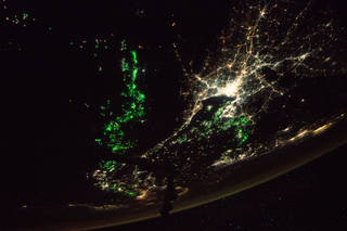
William Stefanov: Oh yeah. Yeah, this is a spectacular image. And again, it kind of speaks to the cameras that we have onboard, which are quite good at taking that kind of imagery. Yeah, what you’re looking at here is you’re looking at the Gulf of Thailand. And so, in the center of the image you can see a city area that’s kind of light whitish colored lights. That’s Bangkok.
Host: Bangkok.
William Stefanov: And in the Gulf of Thailand directly below it and to the left —
Host: The west.
William Stefanov: To the west, yes. I believe that’s west, yes.
Host: Yeah.
William Stefanov: You see all these green lights. And what all those green lights are, those are lights on fishing boats. And the very cool story behind the fishing boats is that those green lights attract fish to the surface. And so, these are all fishermen out there. But they’re not after the fish. They’re after the — they’re after the squid that are eating the fish.
Host: Let’s follow the fish.
William Stefanov: Right. And so, they’re actually squid fishing, or squid farming, squid fishing. And so that’s — so you see here, you see a very interesting use of how humans have used the electromagnetic spectrum to their advantage because they know this green light is what attracts the fish, and then attracts the squid.
Host: Yeah, if you think that a green light on a fishing boat might not be visible from the International Space Station, but there’s got to be hundreds, if not thousands of green lights in this picture.
William Stefanov: Yep, yep. Yep, it’s —
Host: All clustered together.
William Stefanov: It’s a local industry.
Host: One more. Talking about evidence of man on the surface of Earth, here’s a picture of Dubai where clearly that’s a manmade thing.
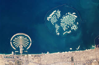
William Stefanov: Yes. Yes. Yeah, what you’re looking at here, this is the Palm Jumeirah development from Dubai. And this is something that astronauts, ever since it’s been visible, this is something that astronauts always key in on because it’s so evident. Yeah, what you’re looking at is a manmade archipelago that was created by dredging of material, sand from the sea bottom and building up these islands. And I think for the Palm Jumeirah there, you’re talking about over 50 million cubic meters of material that was dredged up to form those.
Host: Wow.
William Stefanov: The other one that you can see off to the right, the one that sort of looks like — vaguely looks like a map of the world — that’s because it’s exactly what it was meant to be.
Host: What it was meant to be, yeah. OK.
William Stefanov: And that’s hundreds of millions of cubic meters to form that one. And I believe that’s called the World Islands development. So, this speaks to — this speaks very, very evidently to how humans can reengineer their environments. This is an area that’s like, “Well, this was open water and we just decided, hey, we want to create some new islands here.” And so that’s what we did.
Host: I got some time. I’ve got the money to do it.
William Stefanov: I’ve got some time, got some money, yep.
Host: Remind me again where anybody can try to search and look for these pictures themselves?
William Stefanov: This is a site called the Gateway to Astronaut Photography of Earth. So, you can Google that, and if you want the actual address, it’s eol.jsc.nasa.gov.
Host: I think they’re actually slashes, not backslashes.
William Stefanov: Slash, slash.
Host: But anyway, Gateway to Astronaut Photography.
William Stefanov: Yep.
Host: That’s where you’ll find it.
William Stefanov: That’ll get you there, yes.
Host: Will Stefanov, this is terrific. Thank you very much for educating me. I appreciate it.
William Stefanov: It’s been my pleasure. Thanks for inviting me.
[ Music ]
Host: If there is an upper limit on the amount of time one person can spend online looking at pictures of Earth taken from space, I haven’t found it. But I vow to keep searching. For more than 19 years now, the International Space Station has provided a platform for people and the machines that they’ve made and control to keep an eye on their planet for scientific advancement, for self-sustainability and for just the joy of discovery. You and you and you and you, you’re all invited to join in. Point your internet machine at one of these websites and you can get lost in your own planet. Eol.jsc.NASA.gov is the Gateway to Astronaut Photography of Earth. You heard Will Stefanov mention it. That’s where astronaut photography from all crewed missions is posted. Space station, space shuttle and more. Another, esrs.jsc.NASA.gov/esrs is the site for the Earth Science and Remote Sensing Unit. They have information on current, past and planned sensors that are posted on the International Space Station. One more, issearthserv.jsc.NASA.gov. That’s the space station instrument integration interface. It’s a search tool for multiple International Space Station data sets. We’ve posted all these links in the notes on the episode webpage for this episode at NASA.gov/podcasts. I’ll remind you also that you can go online to keep up with all things NASA at NASA.gov. And you can follow us on Facebook, Twitter and Instagram at all the NASA JSC accounts. When you go to those sites, use the hashtag #AskNASA to submit a question or suggest a topic for us. Please remember to indicate that it is for Houston We Have a Podcast. And you can find the full catalog of all of our episodes by going to NASA.gov/podcasts and scrolling to our name. You could also find all the other exciting NASA podcasts right there at the same spot where you can find us, NASA.gov/podcasts. Very convenient. This episode was recorded on January 30th, 2020. Thanks to Alex Perryman, Gary Jordan, Norah Moran and Belinda Pulido for their help with the production. To David Brady and the International Space Station Program Office for suggesting the topic. And thanks to Will Stefanov for a great conversation and the outstanding pictures. We’ll be back next week.