


For the past several weeks, much of the world has experienced a new normal: one with fewer cars on the road and more time spent at home. Despite these changes, NASA’s Earth-observing fleet continues to operate, collecting key observations on how the planet is responding to this changing behavior due to restrictions in place from COVID-19.
“Much like our satellites, our work continues remotely,” explains Acting Director for NASA’s Earth Science Division Sandra Cauffman. “NASA Earth scientists continue to collect and analyze satellite and ground-based data on a global scale, and our programs are helping to characterize and understand the global environmental signals. We do this by analyzing existing, long-term datasets and funding new, cutting-edge research.”
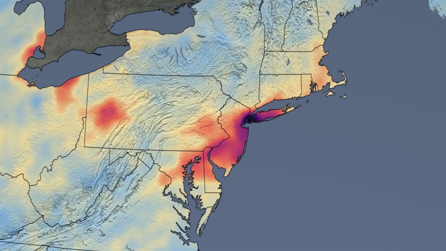
Ongoing observations of air quality and of Earth at night have helped provide immediate examples of how Earth’s systems are responding to these changes in human behavior. From space, NASA’s Ozone Monitoring Instrument (OMI) aboard the Aura satellite and the European Space Agency’s TROPOspheric Monitoring Instrument (TROPOMI) aboard the Sentinel-5P satellite have provided the data behind the images of rapidly falling nitrogen dioxide (NO2) levels around the world due to people sheltering in place.
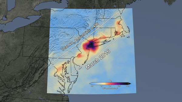
OMI has been measuring total column NO2, an air pollutant commonly associated with burning fossil fuels in motor vehicles and power plants, since it first launched in 2004. In addition, ongoing observations from the Visible Infrared Imaging Radiometer Suite (VIIRS) Day/Night Band on the joint NASA/NOAA Suomi NPP mission, which has been observing our nightlights on Earth since 2011 to help support short-term weather prediction and disaster response, among other applications, have also provided valuable insight into recent changes in global human activity.
These satellites and the rest of NASA’s global Earth-observing fleet, coupled with measurements from our semi-autonomous network of ground sensors, continue to observe the Earth’s changing air, land, ocean, ice and water around the world.
Existing NASA datasets are also being used to help shed light on our understanding of the spread of COVID-19. NASA’s Socioeconomic Data and Applications Center (SEDAC) has launched a new interactive mapping tool that is being used by researchers to visualize global age and sex data overlain with updated data from the Johns Hopkins University of Medicine Coronavirus Resource Center on the spread of COVID-19. This freely available tool may be especially helpful for use in countries with limited access to spatial population data.
Other Earth signals resulting from our global response to COVID-19 remain to be discovered. NASA is beginning to fund new scientific research and to augment existing projects to further investigate these unknowns. For example, more time series data must be gathered in order to obtain a better understanding of some atmospheric signals, such as changes in atmospheric carbon dioxide and methane, due to their relatively long lifespans in the atmosphere. Similarly, more work must be done to determine whether any hydroclimatic observations, such as temperature or humidity, may impact the spread of COVID-19.
NASA is accepting proposals for new research to address Earth system responses to COVID-19 through its Rapid Response to Novel research in the Earth Sciences (RRNES) program element on a rolling basis. Typically focused on studies of the immediate effects of events like hurricanes and earthquakes, RRNES allows the scientific community to quickly leverage existing NASA infrastructure and refocus research that is currently underway to study natural and human-induced Earth events.
NASA continues to leverage its existing partnerships and foster new ones in response to the spread of COVID-19. Across the Earth Science Division’s Applied Sciences Program, NASA scientists from areas such as water resources, health and air quality and disasters are teaming up with federal, state and local agencies to coordinate and share information.
In its role as Chair of the Group on Earth Observations (GEO) Health Community of Practice, a global network that uses environmental observations to improve health decision-making at all levels, NASA is working with stakeholders to share research, applications and activities related to Earth observations to advance knowledge on COVID-19 transmission and impacts.
NASA scientists are also working with the U.S. Department of Agriculture to support users of remotely sensed information to assess crop production. Information from NASA satellites has become more critical as the COVID-19 puts ground data collection at risk. This information is crucial to assess the nation’s food supply and policies to ensure food is available during this pandemic.
NASA is exploring additional partnering opportunities beyond its current joint Earth-observing satellite operations with the European Space Agency and the Japan Aerospace Exploration Agency to collaborate on Earth science research related to COVID-19.
As the world continues to respond and recover from COVID-19’s impacts, NASA’s Earth-observing satellites and ground sensors will keep measuring our planet’s response during this very unusual time.
by Abigail Seadler
NASA Earth Science Division