


Mars has fascinated us for centuries. Through the middle of the 20th century, many scientists believed that the Red Planet was hospitable to some form of life, but those hopes were apparently dashed when the early robotic explorers of the 1960s found a Moon-like cratered terrain with a forbiddingly cold and thin atmosphere of carbon dioxide. More sophisticated orbiters and landers in the 1970s found evidence that water may have once flowed on Mars but a search for signs of life proved inconclusive at best. After the last of the Viking spacecraft fell silent in November 1982, robotic exploration of Mars entered a nearly 15-year hiatus, with just a very brief break. The Soviet Fobos 2 probe entered orbit around Mars in January 1989, operating for two months but not achieving its primary goal of placing a lander and a hopper onto Mars’ larger moon Phobos. The American Mars Observer spacecraft went silent just two days before entering orbit around Mars in August 1993, likely falling victim to a fuel line rupture that caused a catastrophic failure. The Mars Global Surveyor began a new era in the exploration of Mars.
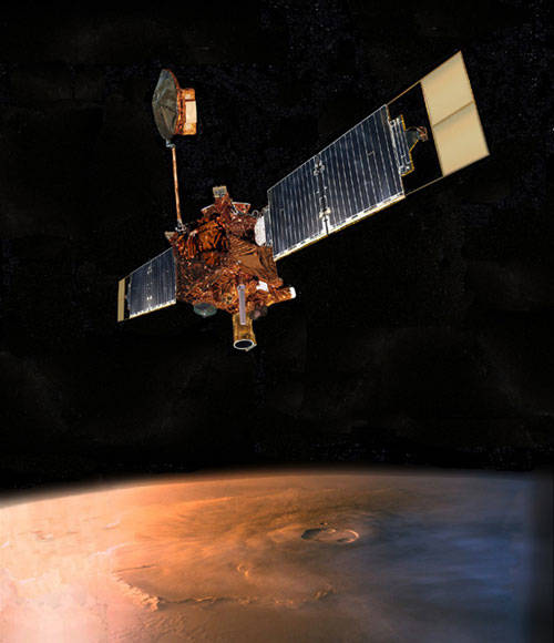
Left: Illustration of the Mars Global Surveyor spacecraft in orbit around Mars.
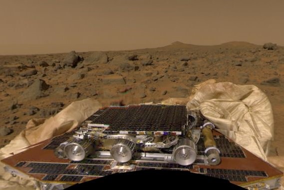
Right: The Sojourner rover sitting atop the Mars Pathfinder lander
before rolling onto the Martian terrain.
Favorable launch opportunities to Mars occur every 26 months, and during the late 1996 window, the United States dispatched two spacecraft to the Red Planet – an orbiter called Mars Global Surveyor (MGS) and Mars Pathfinder, a lander that deployed the first rover on Mars. The landing of Mars Pathfinder and its Sojourner rover on July 4, 1997, began an uninterrupted period with at least one spacecraft, and typically several others, operating either in Mars orbit or on the planet’s surface. This nearly-quarter century of continuous scientific observation is unmatched anywhere else in the solar system except on Earth. The primary contributions of MGS included gathering information on the geology, geophysics, and climate of Mars.
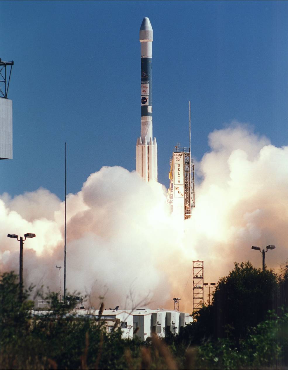
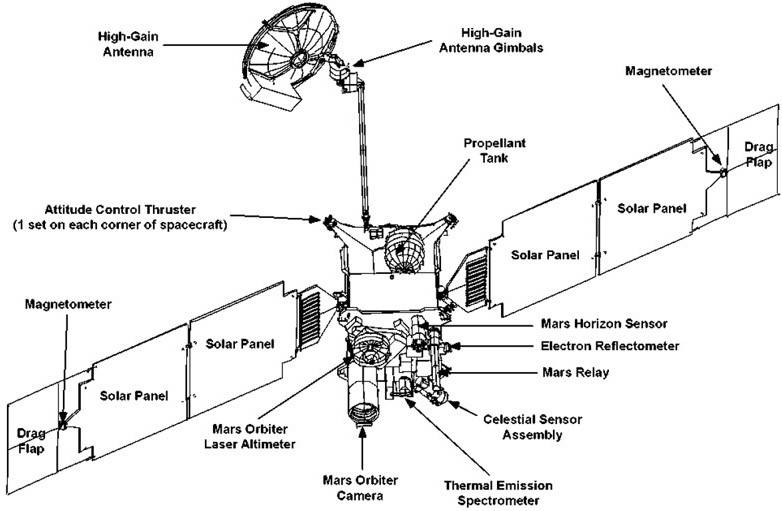
Left: Launch of the Mars Global Surveyor (MGS). Right: Schematic of the MGS
spacecraft showing its major components and scientific instruments.
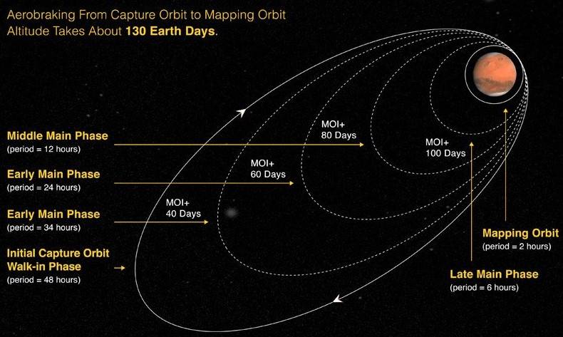
Launch of MGS on a Delta rocket took place on Nov. 7, 1996, from Launch Complex 17A at Cape Canaveral Air Force Station, now Cape Canaveral Space Force Station, in Florida. Once on its way to Mars, one of its two solar arrays did not deploy fully, remaining about 20 degrees from its intended position. The problem did not affect the amount of power available to the spacecraft but impacted the aerobraking maneuvers once it had achieved orbit around Mars. To save weight by reducing the amount of fuel the spacecraft carried, engineers devised a plan to use aerobraking, a technique demonstrated in 1993 by the Magellan spacecraft in orbit around Venus, to place MGS in its final circular mapping orbit around Mars. During aerobraking, a spacecraft dips into the thin upper layers of a planet’s atmosphere to act as brake to change its orbital altitude. Two mid-course corrections refined the spacecraft’s trajectory during its 309-day interplanetary cruise. For its study of the Red Planet, the MGS spacecraft carried six instruments similar to those on the lost Mars Observer mission, including:
- the Mars Orbiter Camera consisting of a wide-angle lens to provide daily weather images and a narrow-angle lens for high-resolution (as small as 1.7 feet) images of surface features;
- the Mars Orbiter Laser Altimeter to measure surface elevations to an accuracy of one foot;
- the Thermal Emission Spectrometer to study the planet’s atmosphere and surface mineral composition;
- the Magnetometer/Electron Reflectometer to study the magnetic properties of the planet;
- the Radio Science investigation to map variations in the planet’s gravity field, using data from the spacecraft’s communications system, its high-gain antenna, and an ultra-stable oscillator (an ultra-precise clock); and
- the Mars Relay antenna to support the Mars Exploration Rovers Spirit and Opportunity by relaying their data back to Earth.
Left: Illustration of Mars Global Surveyor’s (MGS) baseline aerobraking plan that
was modified during the mission due to the incomplete deployment of one solar
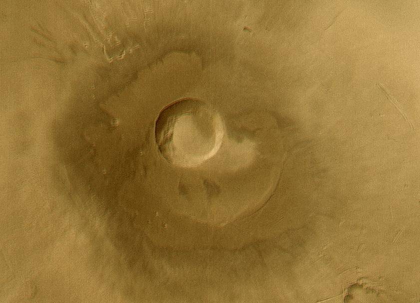
panel. Right: Global images of Mars taken by MGS during northern
hemisphere summer.
Upon arrival at Mars on Sept. 12, 1997, MGS entered a planned highly elliptical 163-by-33,577-mile orbit by firing its main engine. Because the solar panels supplied most of the drag during the aerobraking, engineers modified the process to reduce stress on the partially deployed array. Instead of the planned 130-day aerobraking process, it took MGS, the first spacecraft to operationally use the method to make orbital changes, 17 months to reach its final circular 235-mile-high mapping orbit. The spacecraft began its mapping mission on March 9, 1999. In its Sun-synchronous near-polar orbit, MGS repeatedly imaged Martian surface features under identical solar illumination.
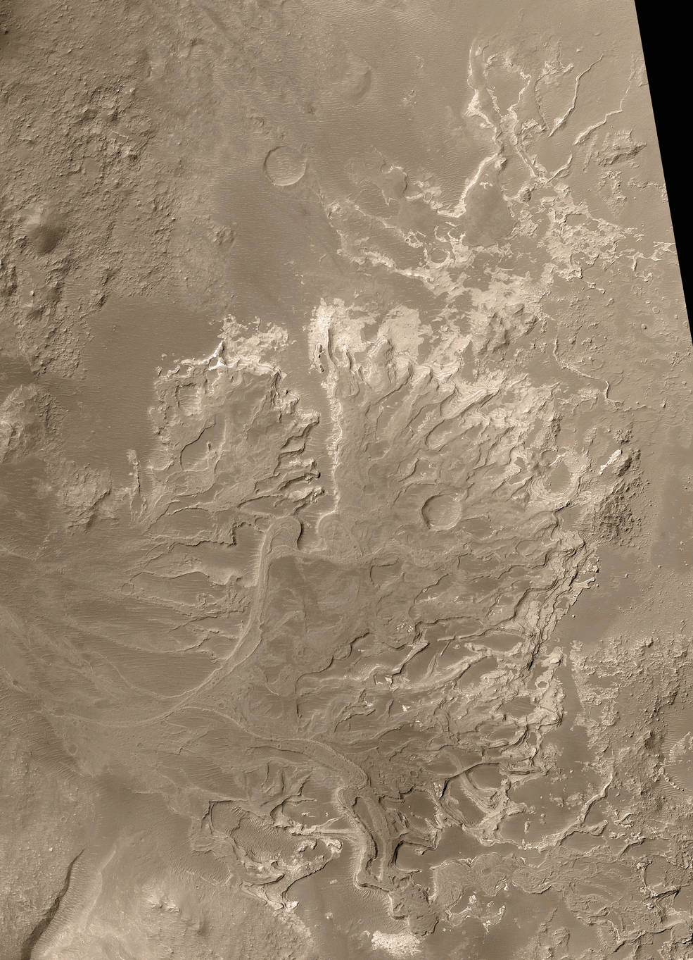
A tiny sampling of the 240,000 images that the Mars Global Surveyor returned during its highly-successful
mission in orbit around Mars. Left: Gullies, possibly caused by water in Gorgonum. Middle left: The
volcanoes Uranius Tholus, upper, and Ceranuis Tholus. Middle right: A possible river delta in an
ancient lake. Right: Pavonis Mons, the middle of the three Tharsis Montes.
By the time MGS’s primary mission of observing the planet for one Martian year, or 687 Earth days, ended on Feb. 1, 2001, it had returned 83,000 images – more than all previous Mars missions combined. Its other instruments also returned unprecedented amounts of information. Data returned by the Mars Orbital Laser Altimeter allowed scientists to build a global elevation map of Mars to a vertical accuracy of one foot. Mission managers granted the spacecraft a one-year extension, and on Feb. 1, 2002, they granted another 11-month extension.
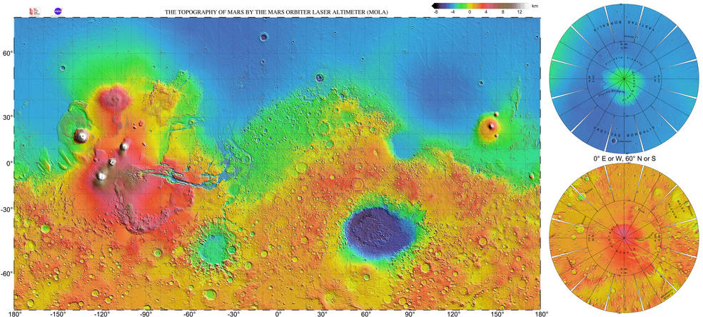
High-resolution topographic map of Mars based on data from the Mars
Global Surveyor’s Mars Orbiter Laser Altimeter instrument.
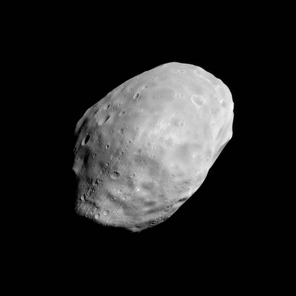
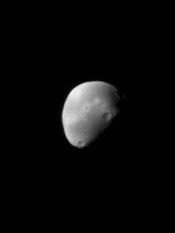
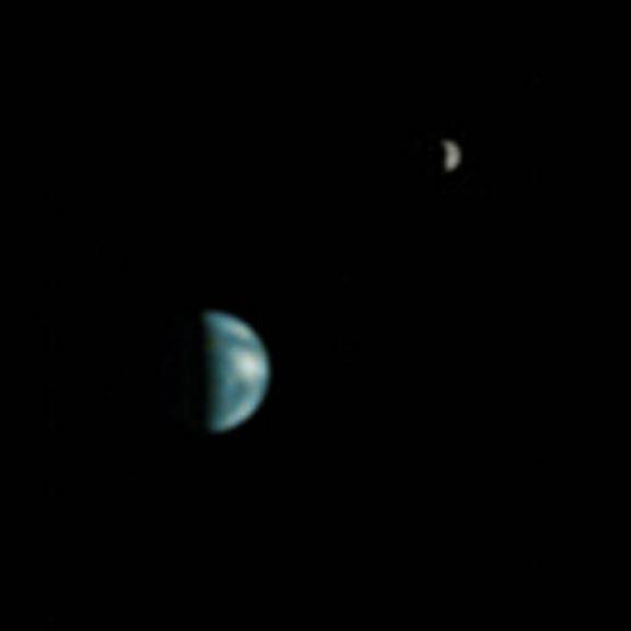
Left: Mars Global Surveyor (MGS) image of Mars’ inner, larger moon Phobos. Middle: MGS image of Mars’
outer, smaller moon Deimos. Right: The first photo of the Earth-Moon system from Mars orbit, taken
by MGS from 86 million miles away.
In addition to imaging the planet, MGS turned its instruments toward Mars’ two moons, Phobos and Deimos, imaging them in unprecedented detail including large boulders on the larger moon. On May 8, 2003, from a distance of 86 million miles, MGS’s camera captured the first image from Mars orbit of the Earth-Moon system, at a resolution high enough to discern continents on Earth.
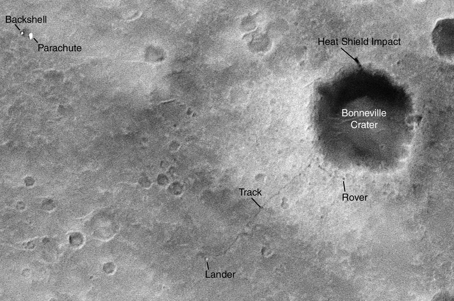
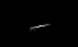
Left: The Mars Global Surveyor (MGS) photographed the landing site of the Spirit
Mars Exploration Rover (MER), including the tracks it made in the Martian soil.
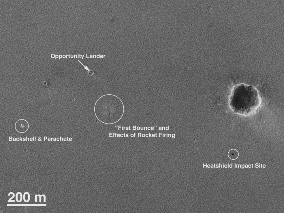
Right: MGS photograph of the Opportunity MER including several of its parts
discarded during the landing sequence.
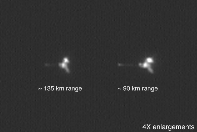
Left: The European Space Agency’s Mars Express spacecraft imaged by Mars
Global Surveyor (MGS). Right: NASA’s 2001 Mars Odyssey imaged by MGS.
MGS began supporting other spacecraft as they arrived at Mars; first 2001 Mars Odyssey in 2001 and three years later the two Mars Exploration Rovers Spirit and Opportunity after they landed on the planet and began their explorations. Not only acting as a radio relay for these spacecraft, MGS also imaged the two rovers on the surface and during close passes imaged both Mars Odyssey and the European Space Agency’s Mars Express in orbit around Mars. However, the MGS mission would not last much longer. Managers granted another mission extension on Oct. 1, 2006, but on Nov. 2 the spacecraft suddenly stopped communicating with Earth. A software error most likely caused the failure. By that time, MGS had more than tripled its expected operational lifetime. During its highly successful mission, MGS returned 240,000 images of Mars, relayed a wealth of scientific information, and assisted other spacecraft in their explorations of the Red Planet.