


![Request for Information – Potential [Placeholder for Prize]](https://assets.science.nasa.gov/dynamicimage/assets/science/psd/solar/2023/09/s/solarsystem_0.jpg?w=1024)


Airborne Science (ASP)
The Airborne Science Program within the Earth Science Division at Ames is responsible for providing aircraft systems that further science and advance the use of satellite data.
Airborne Science lead
Matthew Fladeland
Credits: Scifly Channel
Who We Are
The Airborne Science Program within the Earth Science Division is responsible for providing aircraft systems that further science and advance the use of satellite data. The primary objectives of this program are to:
- Provide platforms to enable essential calibration measurements for the Earth observing satellites, and the validation of data retrieval algorithms.
- Provide sub-orbital flight opportunities to test and refine new instrument technologies/algorithms, and reduce risk prior to committing sensors for launch into space.
- Obtain high-resolution temporal and spatial measurements of complex local processes, which can be coupled to global satellite observations for a better understanding of the complete Earth system.
- Foster the development of our future workforce with the hands-on involvement of graduate students, and young scientists/engineers in all aspects of ongoing Earth science investigations.
To meet these observing objectives ASP maintains and operates a suite of sustained, ongoing platforms and sensors on which investigators can rely from year to year. From these known capabilities the Science Mission Directorate can develop observing strategies. However, an ongoing capability will be resource-constrained and eventually technology-constrained, so that not all observing requirements will be met with the limited core capability. Therefore the program facilitates access to other platforms or sensors on a funds-available, as-needed basis, to accommodate unique and/or occasional requirements. The Program also looks for new or evolving technologies to demonstrate their applicability for Earth science. Depending on the success of the demonstrations and the observing needs, the core capability is expected to evolve and change over time. The speed and extent of change will be balanced against the need for established, known capabilities for long-term planning.
- Satellite Calibration and Validation
- Support New Sensor Development
- Process Studies
- Develop the Next-Generation of Scientists and Engineers
Research Groups
- Atmospheric Chemistry Data Analysis
- Airborne Science Advanced Planning
- Earth Science Project Office (ESPO)
- Meteorological Measurement Systems (MMS)
- Meteorological Support
- NSERC Mission Operations
- Program Management Analysis
- SGE Support
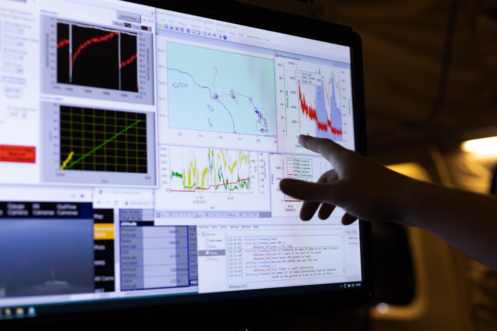
Airborne Science Asset Tracker
The NASA Airborne Science Mission Tool Suite supports the Airborne Science Program (ASP) and the NASA Science Mission Directorate (SMD) Earth Science Division by providing a suite of web-based capabilities to support Airborne Science Missions. ASP Mission Tool Suite is the ground complement to the NASA SensorNet project, which is developing the airborne networking infrastructure to enable high speed SATCOM of aircraft parameter data, and instrument data during flight missions. The ASP Mission Tools Suite provides a common operating picture for improved situational awareness for all participants in NASA Airborne Science missions from scientists and engineers, to managers, as well as the general public. The intent of the system is to encourage more responsive and collaborative measurements between instruments on multiple aircraft, satellites, and on the surface in order to increase the scientific value of the measurements, and improve the efficiency and effectiveness of flight missions. At its most basic, ASP Mission Tool Suite provides a means for visualizing the position of the aircraft and instruments during the course of the mission. Such information is made more useful when compared with or overlaid upon other datasets and model outputs used for mission planning and science data analysis. Additionally, ASP Mission Tool Suite facilitates communication between mission team members to enable analysis and discussion of multiple data sources to help plan and execute science missions.
The ASP Mission Tool Suite contains a core set of tools that provide Airborne Science Participants with a host of capabilities:
- remotely monitor real-time aircraft location
- view current and archived aircraft flight tracks
- ability to add information overlays from a curated product registry
- customized user workspaces
- communication and collaboration tools
- integrated IRC client supporting multiuser and person-to-person private chat
- remotely monitor real-time instrument engineering data
- plotting and graphing
- and more…
Follow Us on Socials
YOUTUBE
Visit Airborne Science at NASA Ames
Programs
NASA Earth Exchange
NEX combines state-of-the-art supercomputing, Earth system modeling, and NASA remote sensing data feeds to deliver a work environment for exploring and analyzing terabyte- to petabyte-scale datasets covering large regions, continents or the globe.

Earth Science Projects Office
The Ames Earth Science Project Office is a small group of success-oriented individuals providing project management for NASA's Science Mission Directorate field research.

Airborne Sensor Facility
The Airborne Sensor Facility (ASF) at NASA Ames supports a variety of airborne research activities for the NASA Earth Science Division.